4 December 2024 The Future is the Product of the Past

The Oldest Known Map of Europe, “Saint-Bélec Slab”

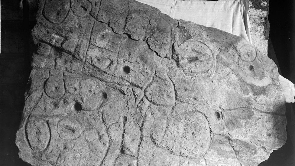
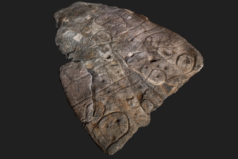
An ornate Bronze Age stone slab (Saint-Bélec slab) that was excavated in France in 1900 and forgotten about for over a century may be the oldest three-dimensional map in Europe.

In 2014, a 2m x 1.5m slab (5 feet x 6.5 feet) was again found in the cellar of a castle in Brittany, France. Archaeologists who study patterns carved on 4,000-year-old stones say they believe these marks are maps of the western region of Brittany. They say this makes the tablet the oldest 3D map of a known area in Europe.

Researchers examined the carved stone slab and dated it to the early bronze age. (MÖ 2150-1600)

Their research, published in the French journal Bulletin de la Société préhistorique française, identified it as the oldest cartographic representation of a known territory in Europe, a likely marker of the political power of the early Bronze Age.

The broken plate was reused for the burial of Saint-Bélec at the end of the Early Bronze Age (ca. 1900-1640 BC). At that time, the slab formed one of the walls of a stone cyst, a small coffin-like stone box used to contain the bodies of the deceased. His engraved face turned towards the inside of the tomb, but its ends were hidden. The plate was transferred to a private museum in 1900 before the collection was taken over by the Musée des Antiquités Nationales (MAN – Museum of National Antiquities) in 1924. Until the 1990s, the Saint-Bélec plate was kept in a niche in the castle cellar. Finally, in 2014, he was found in the castle’s basement.

Saint-Belec Slab 1900
The slab was first discovered in Brittany in 1900.

The research team, including in 2017, began to perform high-resolution 3D research and plate photogrammetry, registering the surface of the plate and its engravings.

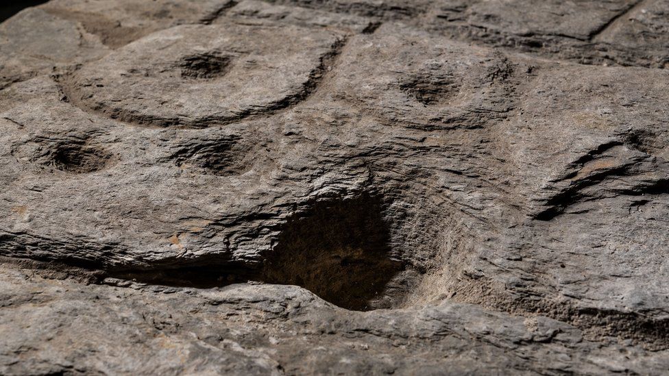
After analyzing the markings and carvings on the stone, the researchers suspected that it might be a map. A study in the Bulletin of the French Prehistoric Society stated that the “repetitive patterns connected by lines” on its surface indicate that it depicts a Finistère region. Researchers say that the dent is a 3D representation of the Odette River valley, and there appear to be several lines that delineate the river network in the area. The geographical location shows that the territory represented on the slab has an accuracy of 80% relative to the 18-mile-long area of ​​the river.

Markings on the rock are believed to depict an area of western Brittany.
Markings on the rock are believed to depict an area of western Brittany. Photo: DENIS GLIKSMAN

“This is probably the oldest map of a territory that has been identified,” Dr. Clément Nicolas from Bournemouth University, one of the study’s authors, told the BBC.

“There are several such maps carved in stone all over the world. Generally, they are just interpretations. But this is the first time a map has depicted an area on a specific scale.”

Dr. Nicolas said the map may have been used to mark a particular area.

“It was probably a way to affirm the ownership of the territory by a small prince or king at the time,” he said.

“We tend to underestimate the geographical knowledge of past societies. This slab is important as it highlights this cartographical knowledge.”

Saint-Bélec Slab is contemporary with the famous Nebra Nebula Disk discovered in Germany. It is the oldest known specific depiction of the cosmos and highlights the cartographic knowledge of prehistoric society.

Related Articles

A 3,400-year-old Pyramid from the Scythian-Saka period found in Karaganda region of Kazakhstan

2 November 2023

2 November 2023

A pyramid belonging to the Scythian-Saka period was found in the Karaganda region of Kazakhstan. Experts announced that the Karajartas...

A 2,000-year-old whistle was found in a child’s grave in the ruins of Assos, Turkey

18 October 2022

18 October 2022

A terracotta whistle believed to be 2,000 years old from the Roman era and placed as a gift in a...

“Important discovery” showing that the Hittite city of Büklükale close ties with the Hurrian society

21 October 2022

21 October 2022

According to Japanese archaeologists, an ancient clay tablet discovered at the Büklükale ruins in central Turkey suggests that a little-known...

Bronze age settlement found under in Swiss lake

23 April 2021

23 April 2021

For the first time, archaeologists discovered traces of a Bronze Age lakeside village beneath the surface of Lake Lucerne. The...

Researchers extract ancient DNA from a 2,900-year-old clay brick

6 September 2023

6 September 2023

Researchers have successfully extracted ancient DNA from a 2,900-year-old clay brick, uncovering a wealth of information about the plant life...

Huge ancient stone murals discovered in central China: “It is an important discovery that enriches and rewrites the art history of the Song Dynasty”

10 October 2022

10 October 2022

Two stone murals from the Northern Song Dynasty (960-1127) have been discovered in Henan Province, central China, and are the...

Ancient terracotta dancers, and musicians unearthed in China

13 November 2022

13 November 2022

Chinese archaeologists recently discovered a large group of terracotta figurines from a tomb in a group dating to the Northern...

Archaeologists have unearthed part of Hadrian’s Aqueduct, one of the Largest Hydraulic Works of the 2nd century AD, and Extremely Rare Greek Coins

11 January 2024

11 January 2024

Archaeologists have unearthed part of Hadrian’s aqueduct, one of the largest hydraulic works of the 2nd century AD, and a...

Severe drought in Italy unearths remains of an ancient bridge in Rome

15 July 2022

15 July 2022

Continued severe heat in Italy has uncovered an archaeological treasure in Rome: a bridge reportedly built by the Roman emperor...

Surprisingly High-Altitude Silk Road Cities Discovered in Uzbek Mountains

25 October 2024

25 October 2024

Archaeologists have discovered two lost medieval cities in the eastern mountains of Uzbekistan that were important hubs on the ancient...

Slavic settlement and burial ground with two unusual graves discovered in Saxony-Anhalt

7 August 2024

7 August 2024

Archaeologists from the State Office for Monument Preservation and Archaeology (LDA) of Saxony-Anhalt have uncovered a wealth of medieval treasures,...

Scientists Create a 3D Model of Lost Temple Relief from a 134-Year-Old Photo Using AI

13 November 2024

13 November 2024

The researchers developed a neural network that can take a single 2D photo of a three-dimensional object and produce a...

‘Holy Grail of shipwrecks’ worth $20 billion in treasure to be raised from seabed

10 November 2023

10 November 2023

A treasure ship described as the “holy grail of shipwrecks” will reportedly be lifted from the sea floor where it...

A farmer picking up ‘trash’ in field in Norway discovered a rare Viking Sword

1 June 2024

1 June 2024

A farmer and his son found a rare Viking sword on his family farm in Suldal, Norway. Archaeologists say this...

Rich Votive Deposit Discovered in the Valley of the Temples of Agrigento

10 August 2023

10 August 2023

At least sixty terracotta figurines, female protomes, and busts, oil lamps, and small vases, a rich votive deposit of bronze...