

Looting is one of the biggest threats to archaeological sites, and detecting it is not always easy. A site that was secretly dug up overnight may look like nothing more than disturbed soil, both from the ground and even in satellite images.
But every action leaves a trace, and looted archaeological sites are no different. The team at HeritageWatch.ai, a nonprofit created by Microsoft’s AI for Good Research Lab, Aliph Foundation, Iconem, and satellite company Planet Labs, is developing an AI system that can detect signs of looting across thousands of archaeological sites using satellite imagery.
The problem
Monitoring cultural heritage sites in remote or conflict-affected areas is extremely difficult. Many sites are spread across large regions where sending people to inspect them is unsafe, impractical, or simply impossible.
Satellite images provide a safer alternative, but analyzing them has traditionally required experts to manually compare images taken at different times and search for possible signs of looting.
This is not a new problem for us. If you’ve read our other articles on AI, you may have noticed a similar pattern: comparing images can be time-consuming for people, while it is exactly the kind of task AI can perform quickly and at scale.
This time, the researchers’ task is detecting looting, which is exceptionally difficult because the evidence is often barely visible. New pits, changes in soil patterns, subtle shifts in ground shape, or slight differences in how the surface reflects light can be easy to miss.
These signs can also resemble natural erosion or routine agricultural activity, making it difficult to determine whether someone has actually disturbed the site.
Building a dataset
To build the system, the team created the largest dataset of its kind, covering 1,943 archaeological sites in Afghanistan. Of these, 898 were confirmed as looted, while 1,045 remained preserved.
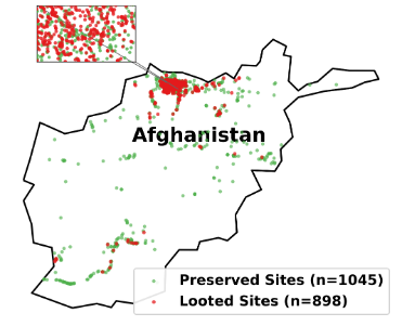
The researchers used the Archaeological Gazetteer of Afghanistan as their starting point, then worked with expert archaeologists to verify and expand the dataset using imagery from Google Earth, ESRI, and Bing. Researchers classified each site based on evidence of deliberate damage recorded before the end of 2023.
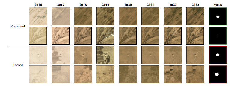
The researchers then turned to PlanetScope satellite imagery, using monthly mosaics with a resolution of 4.7 meters per pixel. The dataset covered the period from January 2016 to December 2023, providing almost eight years of monthly images for each archaeological site.
To make the analysis more precise, archaeologists manually marked the boundaries of every site. These spatial masks outlined each site’s exact footprint, allowing the researchers to later test whether focusing the AI only on the archaeological area, rather than the surrounding landscape, improved its ability to detect looting.
Testing two different approaches
The team tested two fundamentally different ways of detecting looted archaeological sites. The first approach relied on deep learning, using ResNet and EfficientNet models trained directly on raw satellite image patches.
The second used more traditional machine-learning methods, including Random Forest and XGBoost, trained on either manually engineered spectral and texture features or data extracted from newer remote-sensing foundation models such as DINOv3, SatCLIP, and Prithvi-EO.
The results showed a clear difference between the two approaches. ResNet-50, pretrained on ImageNet and given the site footprint masks, achieved an F1 score of 0.926.
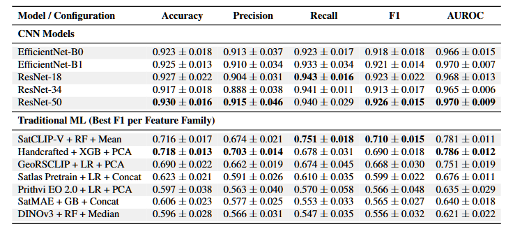
By comparison, the strongest traditional machine-learning setup — SatCLIP location embeddings combined with a Random Forest classifier — reached 0.710. The gap is huge, especially for a task where both failing to detect a looted site and incorrectly flagging an intact one can have serious consequences.
Simple models had the edge
One of the more surprising findings was that the newer, more advanced foundation models did not necessarily perform better. Their embedding, trained on huge satellite-image datasets, performed about the same as, and sometimes worse than, much simpler handcrafted image features.
The researchers suggest that looting leaves highly local signs, mainly small changes in texture, while general-purpose models focus more on broader patterns.
The researchers also looked more closely at which features were driving the model’s decisions. Using SHAP analysis to measure their importance, they found that the strongest predictor was the strength of edges in the near-infrared band.
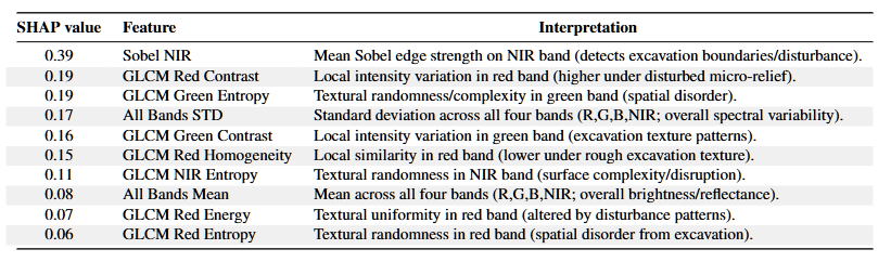
In simple terms, the model was particularly good at picking up sharp boundaries created by excavation. Most of the other important features were measures of texture, including contrast, entropy, and homogeneity, calculated from small patches of the red, green, and near-infrared bands.
Instead of looking for large areas that simply “look different,” the model picked up on something much subtler: the rough, irregular texture left behind by disturbed ground.
Giving the model a clear direction
The most important practical finding may have been surprisingly simple: the model performed much better when it was told where to look. By using manually drawn masks that marked the exact boundaries of each archaeological site, the researchers gave the AI a clear area to focus on.
In some configurations, this led to an improvement of more than 40 percentage points in F1 score, the largest performance boost recorded in the study.
Without those masks, the models had to scan the surrounding landscape, where roads, farmland, modern settlements, and other unrelated features could easily hide the useful signals. Focusing the analysis on the archaeological site itself reduced this noise and made it much easier for the models to detect signs of looting.
Time is a significant factor
The timing of the satellite images turned out to matter more than the researchers expected. When they trained separate models using imagery from individual years, performance was strongest for sites photographed around 2020. Accuracy then dropped for images from both earlier and later years.
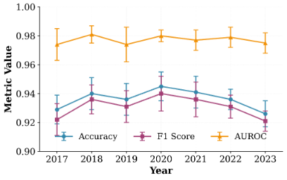
(2017–2023) Credit: Tadesse et al., 2026, arXiv:2602.19608, CC BY 4.0.
The researchers believe the timing of the looting explains this pattern. Most of the looting in their dataset appears to have occurred before 2021, so the clearest excavation signs likely appeared in images from around that period.
As time passes, however, those signs can become harder to distinguish. Wind, rain, erosion, vegetation, and other natural changes gradually alter the ground, allowing the disturbed areas to blend back into the surrounding landscape.
What comes next
The researchers see the system as a monitoring and triage tool, not as a final authority on whether a site has been looted. Its purpose is to help experts cover far more ground by identifying locations that deserve closer attention.
The next step is to see whether the approach can work beyond Afghanistan. The team specifically points to Syria, Sudan, and Egypt as potential regions where the system could help monitor sites at risk of looting.
There is also a major challenge to overcome: the current system still relies heavily on archaeologists to provide site boundaries and labeled examples. To make the technology more practical at a larger scale, the researchers want to explore semi-supervised and active-learning methods that would reduce the amount of manual annotation required. Ideally, the system could adapt to new regions without archaeologists having to map and label every site from scratch.
To encourage that work, the team has also made its code publicly available, along with its dataset methodology, giving other researchers a foundation they can use to test, improve, and extend the approach.
Tadesse, G. A., Bartette, T., Hassanali, A., Kim, A., Chemla, J., Zolli, A., Ubelmann, Y., Robinson, C., Becker-Reshef, I., & Ferres, J. L. “Satellite-Based Detection of Looted Archaeological Sites Using Machine Learning.” Submitted February 23, 2026. arXiv:2602.19608. doi.org/10.48550/arXiv.2602.19608
This study is currently available as a preprint and has not yet undergone formal peer review.
