
AI adoption is becoming increasingly well established in archaeology, with a growing range of systems designed to ease archaeologists’ workloads and automate tasks that once required extensive manual labor. By taking on time-consuming processes, these tools allow researchers to devote more attention to archaeological questions themselves.
One such example is a deep-learning system developed at the University of Haifa, which can transform drone photographs of scattered stones into measurable site plans. By automating much of the analysis, the system can significantly reduce the time required compared with traditional manual methods.
The problem
Drones have helped archaeologists get a broader view of ancient sites for years, but turning aerial images into useful maps has often been a slow and time-consuming task. Mapping hundreds of overlapping photos to identify individual stones and parts of walls can take archaeologists days or even weeks when done manually.
How it works
The semi-automated system, powered by deep-learning techniques, helps address these repetitive tasks by reducing manual effort and saving valuable time. This allows archaeologists to focus on more important aspects of their work.
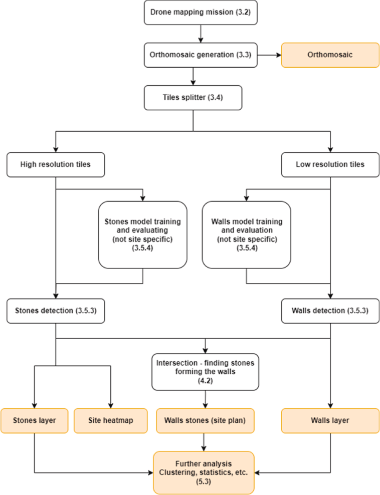
Researchers combine hundreds of drone photos to create detailed maps and elevation models. They then split these maps into smaller sections and use thousands of manually labeled examples to train the models. One model recognizes individual building stones, while the other identifies sections of walls.
After training, the system compares the two layers to accurately locate each stone and connect it to a wall segment when appropriate. It then produces two GIS-ready layers: one showing the exact location of individual stones, and another providing a site plan based on the stones identified as parts of walls.
Dr. Yitzchak Jaffe, one of the study’s authors, says the technology can transform what appears to be a random scatter of stones into a clear picture of how a site was organized, while also reducing the time needed for analysis. Co-author and doctoral researcher Erel Uziel adds that the level of spatial detail provided by the system would previously have required extensive excavation to achieve.
Testing the system
The researchers tested the system at nine archaeological sites in Israel, selecting locations with different types of vegetation, soil colors, stone materials, and preservation conditions. This variety helped the team assess how well the models could work across different landscapes rather than at just one type of site.
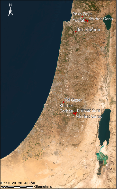
with ArcGIS Pro. Source: Uziel, E., Zohar, M., & Jaffe, Y., “Semi-automatic detection of building stones and wall segments of archaeological ruins,” Journal of Archaeological Science, Vol. 185, 2026, Article 106430.
Across the nine sites, the models identified around 350,000 individual building stones, with approximately 20% classified as part of wall structures. The system also performed well in difficult conditions, including areas with dense vegetation, differences in soil color, and partially preserved structures.
The important nuance
Despite the amount of work AI can automate, the system still relies heavily on researchers. Archaeologists prepare and label the training data, train the models, review their results, and interpret the archaeological features they identify.
Researchers remain involved at several key stages, so the system clearly fits the study’s description of a semi-automated rather than fully automated approach. The original study also describes the methodology as “semi-automatic.” The system reduces the amount of manual mapping required, but it does not automate the whole process.
What the tool offers
The main advantage is not simply faster mapping. By recording individual stones and linking them to wall segments, the system gives archaeologists a more detailed picture of how a site was built. Researchers can use this data to study wall layouts, building patterns, construction methods, and the arrangement of structures across a settlement without manually mapping every stone.
The detailed spatial data can also guide fieldwork. Instead of relying only on surface observations, researchers can use the generated maps to identify areas that deserve closer investigation and decide where excavation may be most useful. This can help focus limited fieldwork on specific structures or parts of a site while reducing unnecessary disturbance to archaeological remains.
The approach could also make it easier to compare different archaeological sites. Because the system records stones and walls as measurable, georeferenced features, researchers can examine building patterns and construction methods across sites using the same type of spatial data.
The research
The system is described in the study “Semi-automatic detection of building stones and wall segments of archaeological ruins,” by Erel Uziel, Motti Zohar, and Yitzchak Jaffe, published in the Journal of Archaeological Science.
The study follows the system from drone imagery and model training to the detection of individual stones and wall segments and the creation of GIS-ready site plans.
The researchers also provide the trained models and code, allowing other archaeologists to test the approach, adapt it to new sites, and further improve the system.
Source: Uziel, E., Zohar, M., & Jaffe, Y. “Semi-automatic detection of building stones and wall segments of archaeological ruins.” Journal of Archaeological Science, Vol. 185 (2026), article 106430. doi.org/10.1016/j.jas.2025.106430
