
A fortress lost for centuries may have been identified in western Türkiye, close to the landscape where one of the most consequential clashes between the Byzantine Empire and the Seljuk Turks unfolded nearly 850 years ago.
Researchers working near Çivril in Denizli Province argue that a large ruined settlement overlooking the Kufi Valley could be the long-sought Myriokephalon Castle, the fortress that gave its name to the Battle of Myriokephalon in 1176. The identification is not yet considered definitive, but the combination of topography, architectural remains, ceramics and medieval written sources has produced one of the strongest candidates proposed so far.
The study was carried out by Prof. Hasan Kara and Assoc. Prof. İbrahim Balık of Pamukkale University and published in the Anadolu Kültürel Araştırmalar Dergisi. Their search grew out of a problem that has occupied historians for more than a century: no consensus exists over exactly where the Battle of Myriokephalon took place.
A castle that was already a ruin in 1176
The battle was fought on September 17, 1176, between the forces of Byzantine Emperor Manuel I Komnenos and the Seljuk army of Sultan Kilij Arslan II. Medieval accounts record a place called Myriokephalon, but the fortress associated with that name had never been securely located.
That detail is especially important because the Byzantine historian Niketas Choniates did not describe Myriokephalon as a functioning military stronghold. By the time Manuel’s army passed it, the place was already old, abandoned, and ruined.
For Kara and Balık, that meant the missing castle did not necessarily have to be a major 12th-century Byzantine fortification. It could instead be the remains of a much older settlement that had fallen out of use centuries before the battle.
The researchers began fieldwork in 2010, examining proposed battle locations across Denizli, Afyonkarahisar, Isparta and Konya before gradually concentrating on Çivril and the Kufi Valley. Historical routes, place names, topographic maps and field observations were compared with descriptions preserved in medieval sources.
One stone changed the search
A breakthrough came in the summer of 2023.
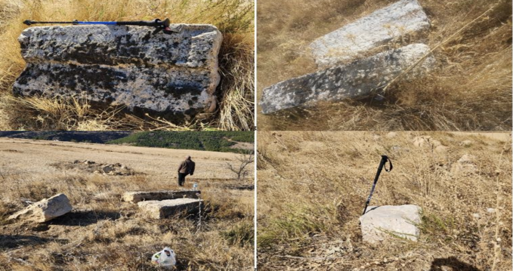
Near Harıldakkaya, east of the point where the Kufi Valley opens onto the Çivril Plain, the researchers noticed a large rectangular architectural block lying on an isolated hillside. Measuring a little over one meter long and bearing cuttings along its edges, the stone suggested that a substantial ancient structure had once stood nearby.
Closer examination changed the picture of the entire hill. Lines initially resembling field boundaries turned out in places to contain constructed foundations and large worked blocks. Repeated visits, drone photography and topographic analysis gradually revealed the traces of a much larger fortified settlement.
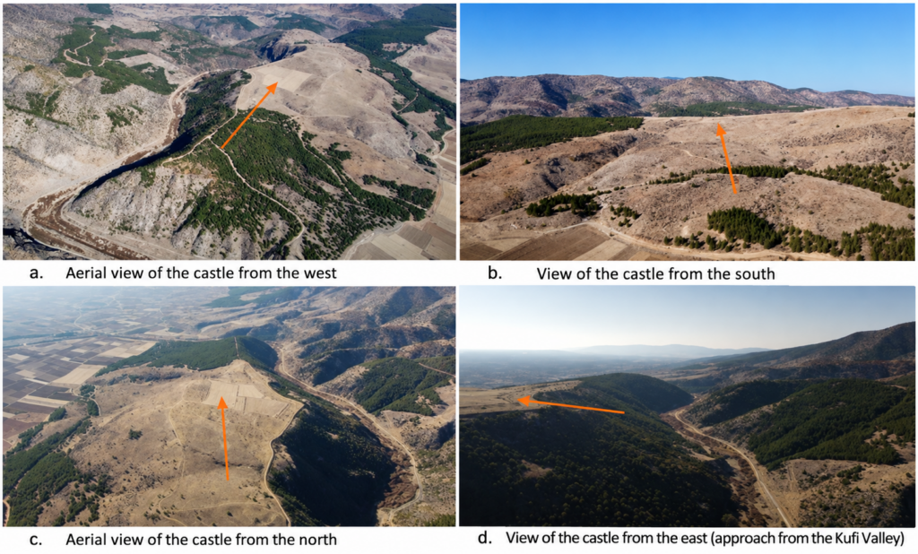
The site occupies a naturally defensive, peninsula-like rise between the plain and the Kufi Valley. It stands roughly 100 to 120 meters above the surrounding landscape and can be approached most easily from the east, while its other sides overlook the valley and plain below.
The visible remains extend across roughly 150 decares, with the settlement stretching about 530 meters east to west and 300 meters north to south. Researchers documented wall foundations, two projecting towers, possible wells or cisterns, architectural blocks, building traces visible from drone imagery, and long lines of masonry running across the site.
More than 100 meters of the southern fortification line can still be followed. Two roughly square towers, each around six by seven meters, once overlooked the Çivril Plain, Işıklı Lake and the route toward Dinar.
The pottery may explain why the castle vanished
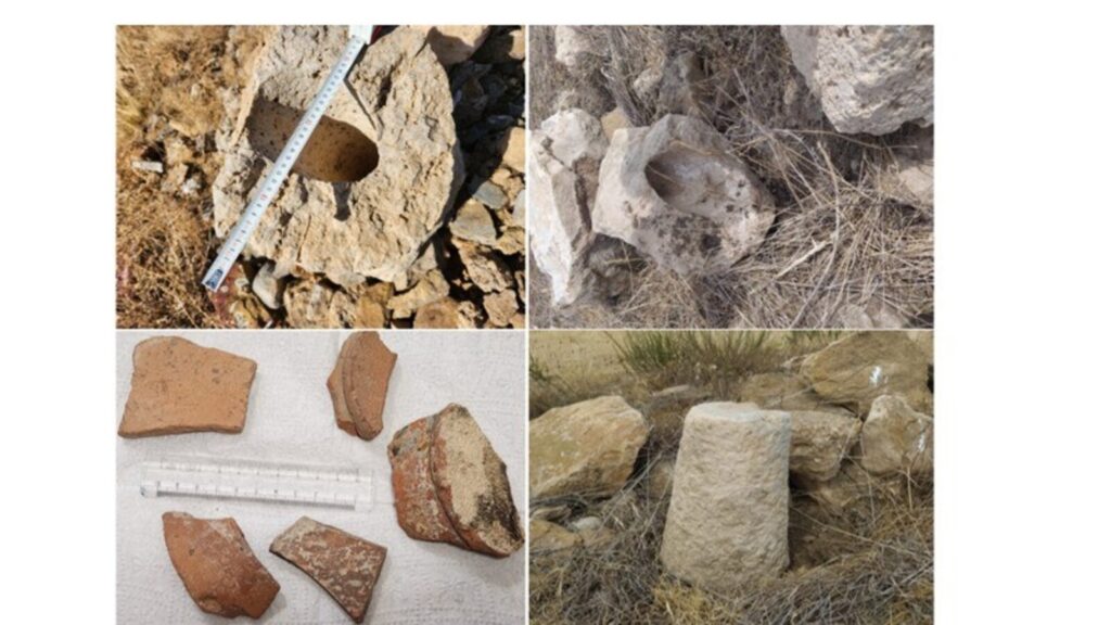
The finds from the surface suggest that the settlement is considerably older than the battle that made the name Myriokephalon famous. Fragments include pithoi, bowls, tiles and amphorae, with some pottery dated to the fourth and third centuries BC and other material assigned to the Roman and Early Byzantine periods.
A twisted amphora handle and numerous bowl fragments were dated by specialists to the fifth and sixth centuries AD. So far, the researchers report no clear surface finds later than the sixth century AD.
That absence may be significant. If occupation really ended several centuries before 1176, the archaeological picture would fit Choniates’ description of Myriokephalon as an old and ruined place rather than an active Byzantine fortress.
Kara and Balık suggest that the settlement may have been abandoned during the conflicts that affected Anatolia between the Late Roman and early medieval periods, although excavation would be needed to establish exactly when and why it disappeared.
The site has also suffered heavily in modern times. Stone was removed for building material, agricultural activity disturbed the surface, roads cut across parts of the fortifications, and some blocks may even have been reused during construction of the Kufi canal. Drone images have nevertheless revealed building foundations that can no longer be recognized easily from ground level.
Does the landscape match the medieval account?
The identification does not depend on the ruins alone. The proposed castle also lies along an old route connecting Homa, identified with modern Gümüşsu, with Işıklı and the Kufi Valley. Choniates described the Byzantine army moving from Homa past the ruined Myriokephalon fortress before entering a narrowing passage.
The Çivril site occupies almost exactly that kind of position, beside the route and immediately before the landscape contracts into the Kufi gorge. This geographical relationship is one of the main reasons the researchers consider the location a strong candidate for the lost fortress.
Other discoveries in the area add further context. About 750 meters south of the proposed fortress, the Karakaya Necropolis and Settlement was officially registered as an archaeological site in 2021. Researchers have also recorded historical graves, possible defensive features and local accounts of weapons reportedly recovered during canal works in the early 1950s. Those reported weapons have not been traced, however, and therefore cannot currently be treated as direct archaeological evidence for the battle.
A strong candidate, but not yet the final answer
Kara and Balık conclude that the ruins about seven kilometers northeast of Çivril are very likely to represent the lost Myriokephalon Castle. At the same time, their paper makes clear that the identification still requires multidisciplinary investigation and archaeological excavation.
That distinction matters. What has been established is the presence of a large, strategically placed fortified settlement with occupation stretching from the Iron Age into the Early Byzantine period. Its identification with Myriokephalon rests on the convergence of archaeology, historical geography and the route described by medieval sources.
Future excavations could provide the evidence needed to test that hypothesis more closely. Coins, datable military equipment, burials or other securely stratified material could determine whether the ruined fortress above the Kufi Valley is indeed the place whose name became permanently linked to the battle of 1176.
If that connection holds, a landscape debated for generations may finally have recovered one of its most important missing landmarks.
Kara, H., & Balık, İ. (2024). Tarihi coğrafya açısından önemli bir keşif: “Yıkık Miryokefalon Kalesi”. Anadolu Kültürel Araştırmalar Dergisi, 8(3), 546–570.
