
Two enormous structures buried beneath the sands near Egypt’s Red Pyramid may not have been roads or stone-transport ramps, as archaeologists once believed. A new study argues that they were part of a sophisticated hydraulic system built to capture floodwater, trap sediment and possibly support one of ancient Egypt’s greatest construction projects.
The proposed system includes two massive dams, a reservoir, a carefully positioned diversion canal and what may be the earliest known example of an advanced triangular spillway in ancient Egypt.
Located across Wadi Dahshur, southwest of the Red Pyramid, the structures may date to the early Old Kingdom, around 4,500 years ago. Their exact age has not yet been confirmed, but their scale and engineering design have raised the possibility that they were connected to the construction landscape created under Pharaoh Snefru.
Two Giant Structures Crossing an Entire Valley
The two structures are difficult to explain as ordinary roads.
Each extends approximately 600 to 700 meters across the full width of Wadi Dahshur. They are anchored into the opposing sides of the valley and have broad, trapezoidal profiles resembling earth-and-rock embankment dams.
According to the researchers’ topographic reconstruction, the structures measure around 15 to 30 meters across at their bases. Their surviving height reaches approximately six to seven meters above the present valley floor, although much of the surrounding landscape is buried beneath windblown sand.
Their positioning is one of the strongest arguments for a hydraulic function. Rather than following the natural direction of travel through the valley, the structures cut directly across the drainage route, precisely where dams would be built to slow or hold back flowing water.
Earlier scholars interpreted the eastern structure as a route for transporting limestone toward the Red Pyramid. The western feature was sometimes dismissed as a natural rise in the landscape. The new analysis suggests that the two structures instead formed a coordinated water-management system.
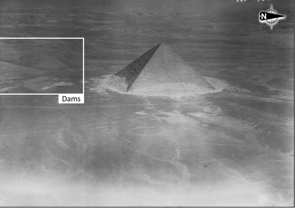
Royal Air Force pictures (1925) from the Red Pyramid, with a view on two dams on the background (white rectangle) – coordinates: 29.80667, 31.20650 © UCL Institute of Archaeology. Reproduced with permission. Credit: Landreau, X., Piton, G. & Hemeda, S. 2026
A Two-Stage System for Water and Sediment
The researchers propose that the dams may have performed different but complementary functions.
The upstream structure could have worked as a check dam. Its purpose would not necessarily have been to store large quantities of clean water. Instead, it may have slowed floodwater and allowed stones, sand and suspended sediment to settle.
Cleaner water could then pass toward the second structure, which may have served as the main retention dam.
The space between the two dams may have formed an intermediate basin capable of temporarily holding water and reducing its force. This would have protected downstream channels from erosion while preventing them from becoming rapidly clogged with sediment.
Such a design would have been especially valuable at Dahshur, where sudden floods could move through soft limestone and marl terrain with destructive force.
The proposed reservoir between the two structures covered approximately 8.5 hectares and had an estimated capacity of around 230,000 cubic meters. Because part of the basin is now filled with sand, the researchers suggest that its original capacity may have been considerably greater—possibly twice the initial estimate.
Taken together, the dams may have slowed flash floods, trapped sediment, and regulated water before it entered a diversion canal or continued downstream.
A Spillway Design Far Ahead of Its Time
The most remarkable feature lies at the center of the western structure.
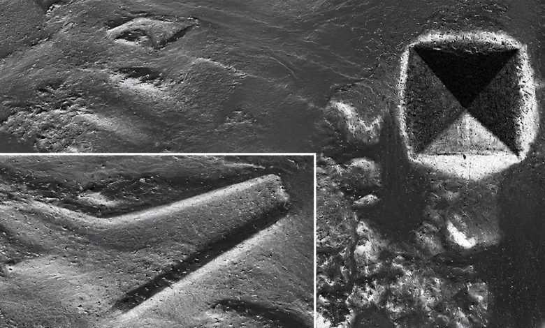
Satellite images and historical aerial photographs reveal a large zigzagging or triangular section. Such a shape makes little sense for a road or transport ramp. In hydraulic engineering, however, it has a clear purpose.
The researchers identify it as a possible “duckbill” spillway—a triangular overflow structure designed to release more water than a straight barrier of the same width.
Instead of forcing floodwater across a single straight line, the triangular layout increases the total length over which water can escape. This allows the dam to discharge a much larger volume without causing the water level behind it to rise dangerously.
The possible spillway had a total crest length of approximately 200 meters. Its height is estimated at between four and seven meters, while its opening angle measured around 70 to 75 degrees.
Hydraulic calculations suggest that this configuration could have released more than twice as much water as a straight spillway occupying the same valley width. That increased capacity would have reduced the risk of water flowing uncontrolled over the top of the dam—a major cause of catastrophic dam failure.
No securely identified duckbill-type spillway has previously been documented in ancient Egypt. Should excavations confirm the interpretation and date, the Dahshur structure could represent an exceptionally early example of this engineering principle.
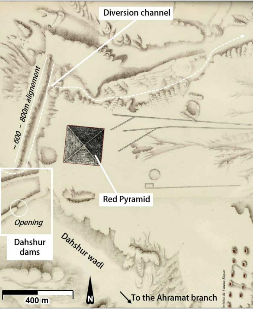
Carte de la Nécropole Memphite” drawn by J. De Morgan (1897) and
showing two dams built across the Wadi Dahshur (bottom left corner), with an opening in the eastern one. Credit: Landreau, X., Piton, G. & Hemeda, S. 2026
Did Ancient Engineers Learn from a Failed Dam?
The design may also point to an ancient process of experimentation and improvement.
Less than 20 kilometers east of Dahshur lies Sadd el-Kafara, widely regarded as one of the world’s oldest large dams. Built during roughly the same broad period, it was eventually destroyed by a powerful flood.
Researchers have long suggested that Sadd el-Kafara failed because it lacked an adequate spillway capable of safely releasing extreme floodwater.
The triangular spillway proposed at Dahshur would have addressed precisely that weakness. By increasing discharge capacity, it could have helped prevent overtopping and reduced pressure on the dam.
The study cautiously raises the possibility that Egyptian engineers were refining their understanding of flood control—perhaps learning from earlier failures and developing more effective ways to manage sudden desert runoff.
This remains an interpretation rather than proof. Nevertheless, it presents ancient Egyptian engineering as a developing technical tradition based not only on labor and scale, but also on observation, risk management and accumulated experience.
A Canal Running Beside the Red Pyramid
The proposed dam system appears to have been connected to a long diversion canal.
Historical surveys indicate that one straight section ran for around 600 to 800 meters parallel to the western side of the Red Pyramid. It then turned east and passed within approximately 40 to 50 meters of the monument.
The full route may have extended for about one kilometer before reconnecting with an ancient wadi and the wider Nile-side drainage network.
Its location naturally raises a major question: could controlled water have assisted the construction of the Red Pyramid?
The canal stood around 40 meters above the Nile Valley, so it would not have allowed boats to sail directly from the river to the pyramid. Ramps would still have been required to raise materials from lower harbors.
Once water reached the plateau, however, small barges or water-assisted sleds may have helped move heavy cargo across relatively level ground. The canal could also have supplied construction workers and animals, supported mortar preparation and reduced dust around the work areas.
It may also have protected the nearby Bent Pyramid causeway and harbor from sudden floods and sediment buildup.
The study does not claim that water power or barges definitively built the Red Pyramid. Instead, it suggests that water management may have formed part of a larger logistical system surrounding the monument.
A Desert That Once Carried More Water
The Dahshur landscape was not always as dry as it appears today.
Paleoclimate evidence suggests that early Old Kingdom Egypt experienced more rainfall and greater environmental variability. Desert valleys that remain dry for most of the year may occasionally have carried powerful flows after intense storms.
The local Dahshur catchment was relatively small, but the researchers propose that runoff may have been diverted from the much larger Wadi Taflah drainage system.
If correct, this connection could have increased the effective water collection area from only a few square kilometers to at least 100 square kilometers—and potentially as much as 400 square kilometers.
This would not have created a permanent river. Instead, the system may have captured seasonal rainfall and short but violent flash floods, turning an unpredictable natural hazard into a controlled resource.
An Extraordinary Theory Still Awaiting Excavation
The evidence is compelling, but the interpretation remains unconfirmed.
The structures have never been archaeologically excavated, and much of the site lies inside a restricted military area. The research is based mainly on satellite imagery, historical maps, aerial photographs, terrain models and hydraulic calculations.
The dams have not been securely dated. It is therefore unknown whether they were built during the construction of the Red Pyramid, before it or centuries later.
Excavation will be needed to determine whether the structures contain deliberately engineered cores, stone erosion protection, water-laid sediments or datable construction materials. Researchers must also establish whether the proposed canal was directly connected to the western dam.
Even with these uncertainties, the study offers a striking new view of ancient Egyptian engineering. The builders of Dahshur may not only have mastered the movement and placement of enormous stone blocks. They may also have understood how to capture floods, remove sediment, regulate water levels and protect monumental construction zones on a scale rarely associated with the pyramid age.
If confirmed, the Dahshur dams would reveal that some of ancient Egypt’s most extraordinary achievements may still lie hidden not inside the pyramids, but beneath the desert landscape surrounding them.
Landreau, X., Piton, G. & Hemeda, S. Two possible ancient dams near the Red Pyramid on the Dahshur Plateau, Egypt. npj Herit. Sci. (2026). https://doi.org/10.1038/s40494-026-02833-9
Cover Image Credit: Landreau, X., Piton, G. & Hemeda, S. 2026
