
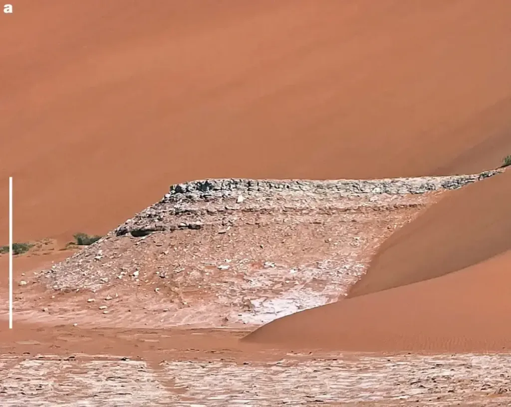
Freshwater has long helped scientists identify the landscapes where prehistoric humans could have lived. But a new study of Arabia’s Empty Quarter suggests that conventional models may have greatly overestimated those areas by overlooking something just as essential to Stone Age survival: suitable rock for making tools.
For early humans, finding freshwater could mean the difference between surviving in an unfamiliar landscape and abandoning it. Scientists have therefore used ancient lakes, rivers and rainfall patterns to reconstruct the routes our ancestors might have followed as they spread across the world. But what if some of those apparently habitable landscapes were missing another resource that people could not easily live without?
A new study published in Nature suggests that this problem may have distorted our understanding of prehistoric settlement. Researchers investigating Arabia’s Rub’ al Khali desert found evidence of dozens of ancient lakes but no stone tools along a vast survey route. Their findings indicate that the availability of suitable stone, not simply water, may have sharply restricted where early human populations could establish lasting settlements.
A Journey Across a Desert That Once Had Lakes
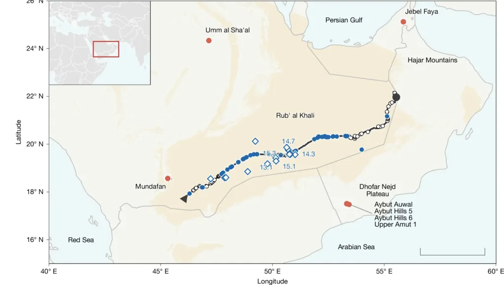
An international research team led by Rudolf W. Dellmour conducted a 35-day expedition across the Rub’ al Khali, also known as the Empty Quarter, between November and December 2023. Traveling in three specially equipped vehicles, the eight-member team followed a route of approximately 1,500 kilometers through the central desert, investigating geological formations and searching for traces of prehistoric human activity.
The researchers examined 125 locations and identified ancient lake deposits at 55 of them. Freshwater mollusc shells, carbonate sediments and ostrich eggshell fragments helped document environments that differed dramatically from the arid landscape visible today. Some of the lake deposits correspond to humid periods between approximately 122,000 and 67,000 years ago, when wetter conditions transformed parts of Arabia.
These ancient lakes presented an important archaeological question. Scientists already knew that humans occupied areas along the desert’s margins during overlapping periods, including Jebel Faya, Mundafan and the Dhofar Nejd Plateau. If freshwater determined where people could live, the central desert’s lakes should also have offered opportunities for settlement.
Yet the expedition found no stone artifacts or evidence of tool production anywhere along its surveyed route. In areas where wind erosion had exposed the ground, surface visibility exceeded 95%, allowing the team to identify even small fossils and fragments of eggshell. The absence of tools therefore demanded an explanation beyond the possibility that the ancient lakes had simply gone unnoticed.
The Resource Missing from the Human Migration Map
For decades, researchers have used reconstructions of ancient climate and waterways to identify possible corridors for human movement out of Africa and across Eurasia. These models frequently treat access to freshwater as a major indicator of whether a landscape could support prehistoric populations. The Arabian survey suggests that such an approach may overlook a fundamental requirement of Stone Age life.
Early humans depended on stone tools to cut, scrape, process animal remains, and manufacture other equipment. Making and maintaining those implements required rocks that fractured in useful, predictable ways, including flint, chert, and quartzite. The presence of water did not guarantee access to those materials.
In the central Rub’ al Khali, suitable stone was particularly difficult to obtain. Much of the desert consists of geological formations that cannot provide the sharp-edged materials needed for toolmaking. Some of the ancient lake basins lay more than 200 kilometers from the nearest suitable rock sources, and researchers found no usable toolmaking stone along approximately 800 kilometers of their route through the desert interior.
The geology of the ancient lakes made the problem even more difficult. Many appear to have received their water from underground sources rather than rivers, meaning that freshwater could accumulate without streams transporting useful stone from distant rocky landscapes. A lake might have provided drinking water and attracted wildlife while offering no practical local supply of material for tool production.
More Than Half of Water-Accessible Arabia Failed the Stone Test
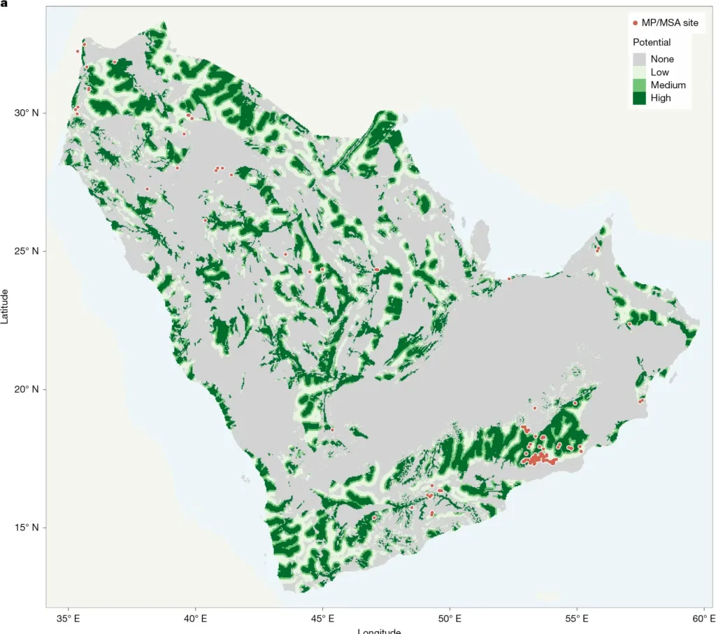
The researchers wanted to determine whether the situation in the Empty Quarter reflected a wider geographical pattern. They developed a model that combined reconstructed access to water with the distribution of stone suitable for making tools, then compared its predictions with documented prehistoric archaeological sites.
The results revealed a substantial difference between landscapes that had freshwater and landscapes that offered both essential resources. Approximately 57% of water-accessible terrain across the Arabian Peninsula lay on geological formations classified as lacking suitable toolmaking stone. In other words, more than half the territory that appeared potentially habitable when assessed for water alone faced an additional limitation.
The team tested the approach against 301 Middle Stone Age findspots documented in Oman and examined a wider compilation of 363 Middle Paleolithic and Middle Stone Age sites across Arabia. Including stone availability improved the model’s ability to distinguish known archaeological locations from other areas. Its statistical performance increased from an area-under-the-curve score of 0.695 for the water-based model to 0.768 when researchers incorporated suitable stone resources.
That improvement does not mean the model can reconstruct every journey or identify every ancient campsite. Its geological data also have limitations, particularly where small deposits of useful stone may escape regional mapping. Nevertheless, the findings suggest that relying on freshwater alone can substantially exaggerate the territory available for sustained occupation.
Map of the archaeological survey across Arabia’s Rub’ al Khali desert. Blue circles mark 55 locations with evidence of ancient lakes, while red circles indicate dated Paleolithic sites around the study area. Credit: Dellmour et al., Nature (2026), Fig. 1a (CC BY 4.0; cropped from original).
Why Carrying Stone Was Not Always Enough
Stone Age populations were capable of traveling considerable distances and transporting tools or raw materials with them. But the researchers emphasize an important difference between carrying a few finished implements during a journey and regularly supplying a community with material for making new tools.
Evidence from well-studied Middle Paleolithic sites indicates that most stone used in toolmaking typically came from sources within approximately five kilometers. Material transported over distances greater than 20–30 kilometers generally contributed a much smaller proportion of archaeological assemblages. Communities could obtain stone from farther away, but maintaining that supply over generations would require repeated journeys and considerable effort.
This helps explain why the distance between water and stone mattered so much in the Empty Quarter. People passing through might have carried the tools they needed, but occupying its interior lakeshores for extended periods would have demanded a reliable system for replacing worn or broken implements.
Other archaeological landscapes offer revealing comparisons. Around the ancient lake at Jubbah in northern Saudi Arabia, prehistoric communities had access to both freshwater and local stone resources, and they left substantial evidence of occupation. In the Duqm region of Oman, suitable stone was abundant, but freshwater was scarce, while archaeological sites remained relatively uncommon. Both cases support the argument that neither resource was sufficient on its own.
A Different Picture of the Prehistoric World
The implications extend beyond Arabia. The researchers point to archaeological patterns in Libya, Egypt, Tibet, and North America where access to particular stone resources also appears to have influenced settlement. On Libya’s Messak Plateau, for example, 91% of the Middle Stone Age occurrences discussed in the study cluster near suitable stone outcrops despite the presence of water in surrounding areas.
These comparisons suggest that stone-tool-dependent populations sometimes organized their movements around the places where they could obtain reliable raw materials. As a result, landscapes that appear connected on a map of ancient rivers and lakes may have contained separate zones of occupation, divided by areas where essential resources were difficult to obtain.
The study’s authors describe prehistoric Arabia as a patchwork of resource-rich locations rather than a single continuous corridor that became habitable whenever the climate turned wetter. The distinction matters for research into human dispersal because a route that looks possible in a climate reconstruction may have presented practical obstacles to the people attempting to cross it.
There are limits to what the findings establish. The absence of artifacts during the Rub’ al Khali survey does not prove that humans never entered the desert interior, and brief visits could have left little surviving evidence. Nor does the Arabian model establish how much of the entire prehistoric world was habitable.
What the research does show is that some existing models may have assigned too much potential living space to early humans. Water could open a landscape to exploration, but the location of useful stone may have determined whether people could remain there, establish communities, and continue moving into new territory.
The routes our ancestors followed may therefore have depended not only on where ancient rivers flowed or lakes formed, but also on where the ground provided the materials needed to survive.
Dellmour, R.W., Coco, E., Samawi, O. et al. Stone and water governed early human settlement of the desert. Nature (2026). https://doi.org/10.1038/s41586-026-11180-5
