
For nearly two thousand years, the rivers of the Pyrenees kept part of their Roman past hidden in plain sight. Gold moved through these mountain waters in tiny grains, carried from ancient deposits into terraces, ravines, and riverbeds. Local communities knew it. Roman writers hinted at it. Medieval Islamic sources later praised the quality of gold from the Segre River. Yet one question remained difficult to prove: did Rome organize large-scale gold extraction in this high Pyrenean landscape?
A new study now offers the clearest answer so far. Researchers from the University of A Coruña and the Autonomous University of Barcelona have confirmed Roman-era alluvial gold mining at Les Guilleteres d’All, in Cerdanya, Girona, in the Eastern Pyrenees. By dating sediments buried inside a hydraulic mining reservoir, the team has shown that the mining system was active during the Roman period and was likely abandoned around the late second or early third century CE.
A Roman mining landscape hidden in the mountains
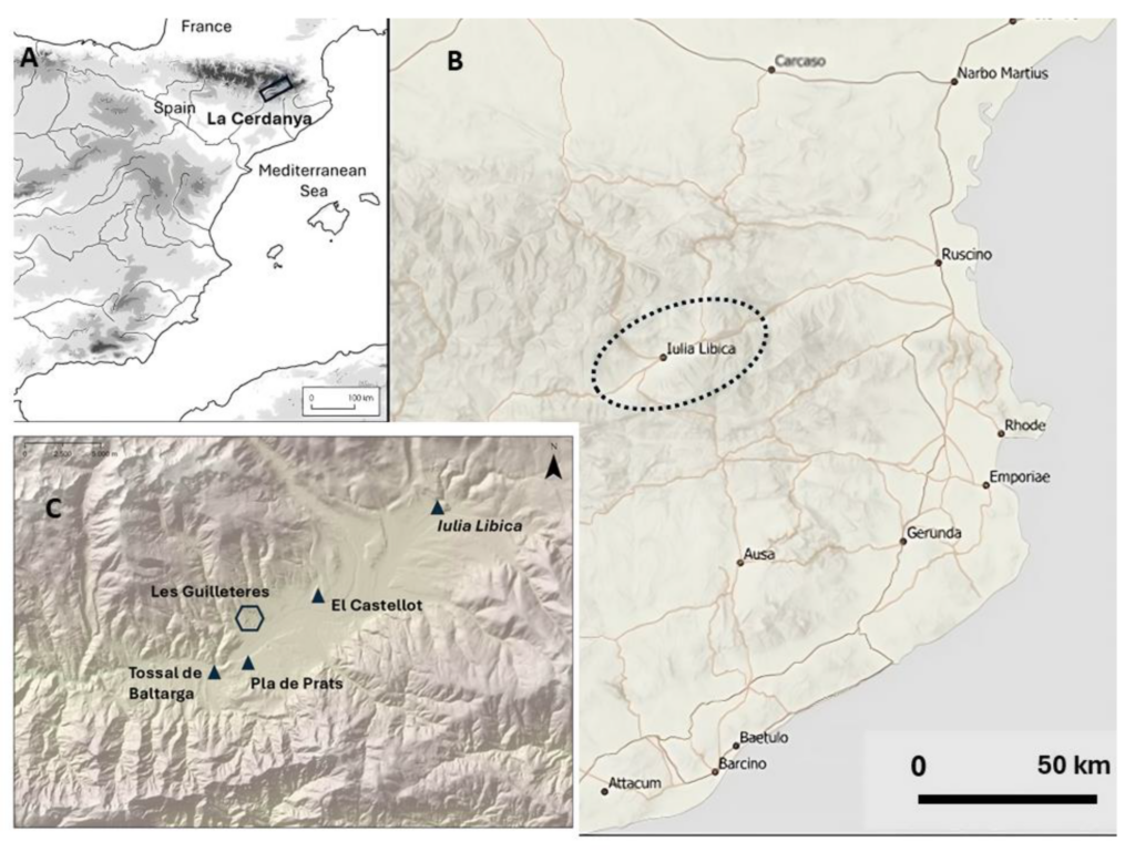
Les Guilleteres d’All lies on the northeastern edge of the Cerdanya Valley, a high mountain basin in Catalonia surrounded by peaks rising toward 2,900 meters. Today, the landscape is marked by eroded ravines, exposed clay and marl, and strange cuts in the terrain that do not follow the natural slope of the land.
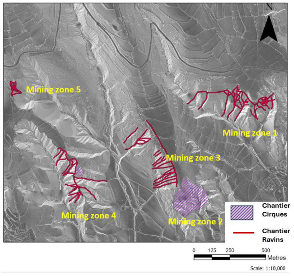
For archaeologists, these marks were not random scars. They resembled hydraulic open-cast mining structures known from other Roman goldfields. Some were narrow, trench-like features called chantier-ravins. Others formed broader extraction fronts, including a large chantier-cirque roughly 300 meters across. These structures would have used controlled water flow to erode gold-bearing alluvial deposits, releasing tiny particles of gold trapped in ancient sediments.
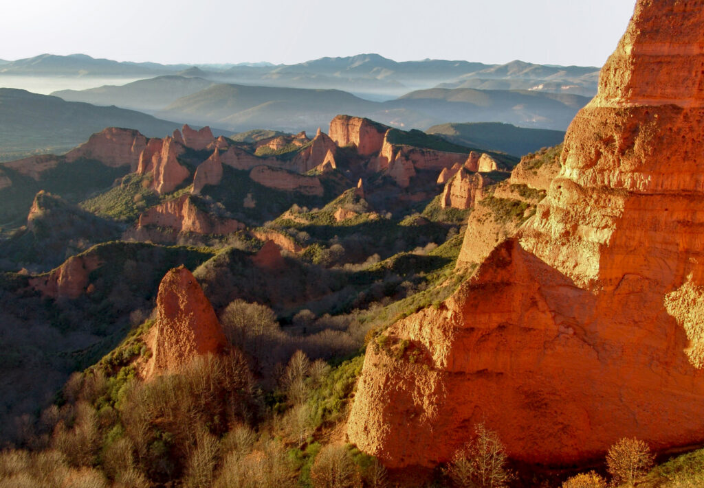
The scale is smaller than famous Roman mining zones such as Las Médulas in northwestern Spain, where hydraulic mining reshaped entire hillsides. But Les Guilleteres still represents an engineered landscape. Researchers estimate that around 2 million cubic meters of earth were removed there.
📣 Our WhatsApp channel is now LIVE! Stay up-to-date with the latest news and updates, just click here to follow us on WhatsApp and never miss a thing!!
The reservoir that preserved the answer
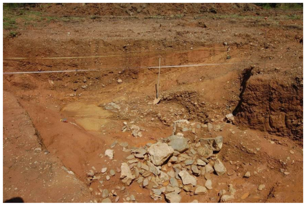
The main problem was dating. The shapes of the ravines strongly suggested Roman hydraulic mining, but morphology alone was not enough. The site had yielded only limited archaeological material, including pottery fragments found in a buried water reservoir.
That reservoir became the key.
Excavations carried out between 2010 and 2012, followed by later work in 2019 and 2022, revealed part of a water-control system built into the mining area. The excavated ditch measured about 4.5 meters wide and reached 1.5 meters deep. A dam made of large stone blocks, some measuring 50 to 60 centimeters across, helped retain and regulate water. Smaller stones lined the sides.
The reservoir floor followed the natural slope of the hillside. When the system was active, water would have been collected, directed, and released to wash down gold-bearing sediments. Once abandoned, fine material settled in stagnant water at the bottom of the structure. Those buried sediments became the archive researchers needed.
Dating the last light seen by ancient quartz
To date the reservoir fill, the team used optically stimulated luminescence, or OSL. The method measures when mineral grains, especially quartz, were last exposed to sunlight before burial. Once buried, quartz grains begin accumulating energy from natural radiation in the surrounding sediment. In the laboratory, that stored signal can be measured to estimate when deposition occurred.
This was crucial because the reservoir lacked organic remains suitable for radiocarbon dating. OSL allowed researchers to date the sediment itself.
Two samples were taken from fine-grained layers near the bottom of the reservoir, at depths of 1.6 and 1.8 meters. The results produced broad but meaningful ranges. One sample pointed to a period between the late first century and early fifth century CE. Another, depending on the measurement model, overlapped with Roman and later Roman chronological ranges. When placed against the archaeological and historical evidence, the researchers argue that the abandonment of the mining system most likely occurred no later than the late second or early third century CE.
This does not necessarily date the beginning of mining. Instead, it dates the moment when the hydraulic system was no longer maintained, and sediments began to accumulate in the reservoir. In other words, the OSL results illuminate the end of Roman mining activity at Les Guilleteres.
Gold, Rome, and Iulia Libica
The discovery gains significance from its location. The mines lie close to Iulia Libica, present-day Llívia, the only Roman city documented in the Pyrenees. Founded in a strategic mountain territory, Iulia Libica likely served as an administrative and economic center for controlling local resources .
Ancient sources already suggested that the region had a connection to gold. Pliny the Elder mentioned Pyrenean gold, while Martial made a literary reference that scholars have linked to gold-producing areas around Iulia Libica. Archaeology has added further clues. At El Castellot de Bolvir, researchers previously identified a metallurgical workshop associated with gold, silver, lead, and cinnabar production. At Pla de Prats, near the mines, a Roman necropolis produced a gold bracelet weighing 23 grams, an unusual luxury object in a mountain setting.
The new luminescence dates now give this scattered evidence a firmer chronological frame. Roman engineers were not merely aware of Pyrenean gold. They appear to have built and managed a hydraulic system to extract it.
A mine that rose and fell with a city
The study also raises a larger historical question. Did the decline of Iulia Libica affect the mines?
Archaeological evidence suggests that parts of the Roman city, including its forum and domestic sectors, were abandoned from the late second or early third century CE. That timing fits the likely abandonment of the Les Guilleteres hydraulic structures. The researchers stop short of claiming a direct cause-and-effect relationship, but the overlap is striking.
Roman hydraulic mining required organization, labor, technical knowledge, and control over water infrastructure. If the nearby urban center declined, maintaining such a system may have become impossible or no longer profitable. Les Guilleteres may therefore preserve not just evidence of Roman extraction, but also the fading of a mountain economy tied to imperial power.
A new chapter in Pyrenean archaeology
The confirmation of Roman gold mining in the Eastern Pyrenees adds an important new region to the map of Roman resource exploitation in Hispania. It also shows how scientific dating methods can clarify landscapes where artifacts are rare but human engineering is written into the terrain.
At Les Guilleteres d’All, the evidence is not a hoard of coins or a glittering treasure. It is quieter: a buried reservoir, fine sediment, quartz grains, and the memory of water once used to tear gold from the mountain soil. For Roman engineers, the Pyrenees were not a remote frontier. They were a landscape of resources, routes, cities, and wealth.
Nearly 1,700 years after the water stopped flowing through the mining channels, light trapped inside ancient sediment has finally given the mines their date.
Sanjurjo-Sánchez, J., Morera Camprubí, J., & Vila, O. O. (2025). First Evidence of Roman Gold Mining Obtained by Luminescence Dating of Sediments in Les Guilleteres D’All (Cerdanya, Girona, Eastern Pyrenees). Land, 14(9), 1912. https://doi.org/10.3390/land14091912
Cover Image Credit: Landscape of Las Médulas, Spain, the result of hydraulic mining on a vast scale by the ancient Romans. Public Domain