

A new university project is using virtual reality, pop-up exhibits, and interactive displays to bring a 1,500-year-old mosaic masterpiece, along with its Göttingen copy, to a new generation.
Tucked away in the collections of the University of Göttingen’s Archaeological Institute sits an unlikely treasure: a large-scale replica of the oldest known map of the Holy Land. Now, backed by a €10,000 grant from the Novus Foundation, that map is finally stepping out of the shadows — set to become far more visible, and far more interactive, than ever before.
A Mosaic That Mapped the Ancient World
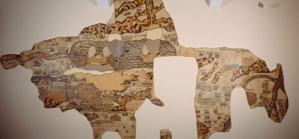
The original masterpiece behind this story isn’t in Germany at all. It’s a floor mosaic in St. George’s Church in Madaba, Jordan, assembled from thousands of painstakingly placed stone tesserae sometime in the 6th century. Known today as the Madaba Map, it’s widely regarded as the earliest surviving cartographic depiction of the Holy Land and, above all, of Jerusalem itself.
Far more than a simple grid of marked cities, the mosaic captures an entire imagined world: a sweeping vision that stretches from Lebanon down to the Nile Delta, alive with towns, landscapes, and pilgrimage sites that held deep meaning for those who walked that land sixteen centuries ago.
“It shows how people in late antiquity imagined the biblical landscape,” explains project leader Dr. Jon C. Cubas Díaz.
Göttingen’s Own Piece of the Story
Göttingen’s connection to the map runs deeper than a simple replica. The large-format copy housed in the university’s collection of plaster casts of ancient sculptures was produced in the 1970s using original mold impressions taken directly from the mosaic — making it a rare and historically valuable artifact in its own right.
“This copy isn’t just an impressive display piece,” says Cubas Díaz. “It’s also an important document in the research history of the Madaba Map itself.”
That dual identity — as both replica and relic — is exactly what the new project, titled “Auf der Karte nach Jerusalem” (“On the Map to Jerusalem”), aims to explore. Students will dig into the material and production history of the Göttingen copy, trace its paper trail through university archives, and examine how the map has been received and interpreted since it arrived on campus.
Bringing an Ancient Map Into the Digital Age
The real innovation, though, lies in what comes next. Students aren’t just studying the map — they’re designing how the public gets to experience it, with formats tailored to different audiences: schoolchildren, curious visitors, church communities, and specialists alike.
Plans include: Interactive kiosks displaying high-resolution imagery of the mosaic’s intricate detail
Virtual reality elements that let visitors virtually step inside St. George’s Church in Madaba
Pop-up exhibitions popping up across the university, the city, and the wider region
The Novus Foundation’s funding will go toward exhibition equipment and media technology that won’t just serve this one project — it will remain part of the university’s collection, ready to support future exhibitions for years to come.
In an era when historical artifacts often stay locked away in archives, this project flips the script: pairing a 1,500-year-old mosaic with cutting-edge VR technology, and putting university students in the driver’s seat as both researchers and storytellers. The result is a rare chance for the public to engage with one of the ancient world’s most remarkable achievements in cartography — not from behind glass, but up close, digitally, and on their own terms.
For those unfamiliar with it, the Madaba Map itself is worth a closer look. Created in the 6th century as a floor mosaic from thousands of small stone tesserae, it still lies today in St. George’s Church in Madaba, Jordan, and is recognized as the oldest surviving map of the Holy Land, offering an extraordinarily detailed view of Jerusalem as it was imagined in late antiquity.
The mosaic stretches far beyond the city itself, tracing landscapes, settlements, and pilgrimage routes all the way from Lebanon to the Nile Delta. Göttingen’s connection to this ancient masterpiece comes through its large-format replica, cast in the 1970s from original mold impressions and preserved ever since in the university’s collection of plaster casts — a copy that has, over the decades, become a historical artifact in its own right.
