
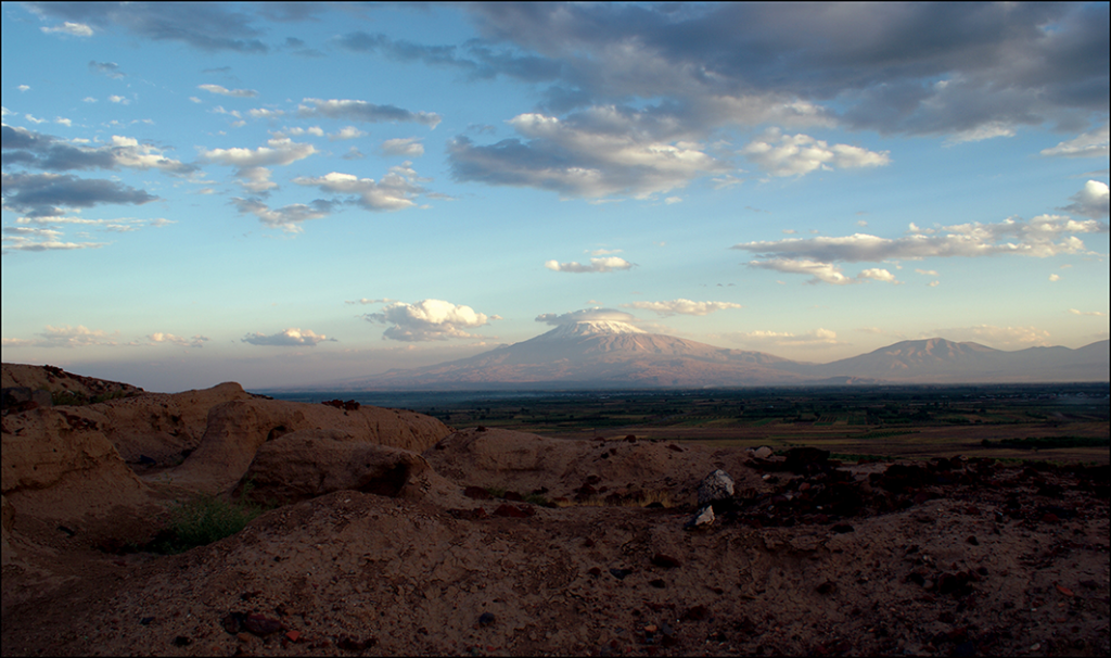
The Ararat Plain can look deceptively ordinary from the ground. Fields, roads, irrigation ditches, and villages spread across one of Armenia’s most important agricultural regions. But seen from above, especially through the eyes of Cold War spy satellites, the land begins to show another story: long-buried channels, levees and traces of waterworks that may reach back to the kingdom of Urartu nearly 2,700 years ago.
A new study published in Antiquity has mapped 1,019.05 kilometers of water-management features around the Urartian fortress of Argishtikhinili, near Armavir in Armenia. Among them, researchers identified 134.6 kilometers of potential ancient canals concentrated mainly around the fortress. The discovery suggests that this landscape was not simply fertile by nature. It was engineered.
The research was carried out by Nazarij Buławka and Krzysztof Jakubiak of the University of Warsaw, together with Inessa Karapetyan of the National Academy of Sciences of Armenia. Their work combines remote sensing, archival satellite imagery, radar data, and elevation models to reconstruct a buried hydraulic system in one of the most historically charged regions of the South Caucasus.
A fortress built where water had to be commanded
Argishtikhinili was founded during the reign of King Argishti I, who ruled Urartu between 786 and 764 BC. The kingdom of Urartu, a powerful rival of Assyria, controlled territories across eastern Anatolia, Armenia, the South Caucasus, and northwestern Iran during the early first millennium BC.
The fortress was not placed randomly. It stood between two natural elevations, each crowned by a citadel. One appears to have served political authority, the other religious purposes. From this position, Urartian power could watch over the Araks Valley and organize the agricultural production needed to sustain cities, soldiers, and state institutions.
📣 Our WhatsApp channel is now LIVE! Stay up-to-date with the latest news and updates, just click here to follow us on WhatsApp and never miss a thing!!
Yet the surrounding plain had a basic problem. Without irrigation, stable cultivation was difficult. Ancient inscriptions from the foundation of Argishtikhinili state that Argishti I ordered five canals to bring water to the urban core and to nearby fields, gardens, and vineyards. One inscription even notes that the land had previously lain fallow, implying that water scarcity had discouraged earlier settlement.
That detail matters. The researchers point out that archaeological surveys have not found evidence for earlier habitation in the immediate area before the Urartian foundation. The canal system, therefore, was not a minor improvement to an already thriving landscape. It may have been the condition that made large-scale settlement possible.
Searching for canals without digging them up
Instead of excavating kilometers of farmland, the team turned to the sky.
They used declassified CORONA and GAMBIT satellite images taken in the 1960s and 1970s, before modern mechanized agriculture and urban expansion erased many subtle traces. GAMBIT imagery, with a resolution of 0.6 to 1.2 meters, proved especially important for distinguishing older water features from modern canals.
The researchers also used Landsat 5 multispectral images, Sentinel-1 radar data, TanDEM-X elevation models and a 5-meter Euro-Maps 3D digital surface model provided through the European Space Agency. These datasets allowed them to detect differences in vegetation growth, soil moisture, surface roughness and minute changes in terrain.
In archaeology, such differences can be decisive. A filled canal may no longer be visible as a trench, but plants growing above it may behave differently. A levee may be too low to notice while walking through a field, but it can appear clearly in a relief model. A dry channel may disappear under ploughing, yet still leave a mark in soil color or elevation.
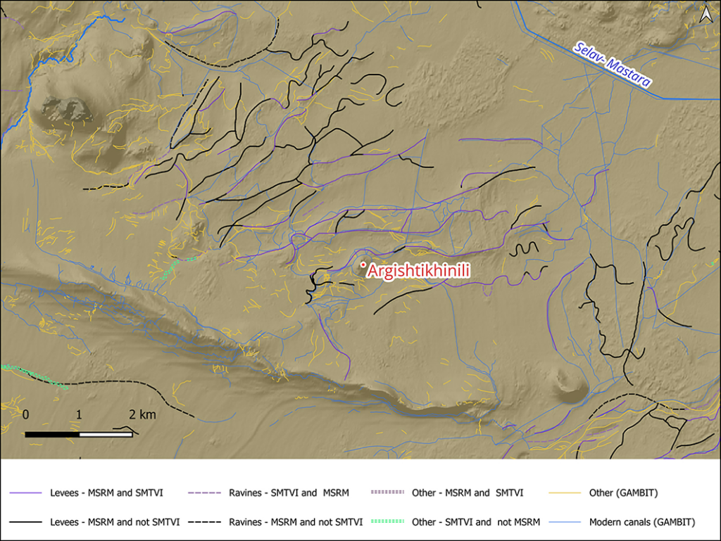
By combining these methods, the researchers identified several categories of water-related features. Modern canals accounted for 428.9 kilometers. Former mountain or Araks stream beds accounted for 419.6 kilometers. Incised palaeochannels, still visible as deeper cuts in the terrain, made up 36 kilometers. The most intriguing group consisted of 134.6 kilometers of potential ancient canals.
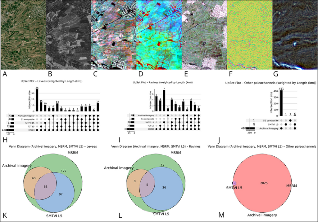
Visibility of water-management features around Argishtikhinili, shown through Bing and GAMBIT imagery, vegetation and radar data, relief models, and mapped levees, ravines, and palaeochannels. Figure by N. Buławka. Credit: Buławka et al., 2026.
What the hidden lines suggest
The possible ancient canals are concentrated around Argishtikhinili, and many follow a northeast alignment. That pattern may indicate a connection with dry stream beds or with a larger intake system linked to the Araks River. The team also observed that some modern canals have meandering forms, suggesting they may follow older watercourses rather than entirely new routes.
This does not mean every mapped canal is Urartian. The researchers are careful on that point. The landscape remained occupied after the fall of Urartu around 590 BC. During the Hellenistic period, Armavir rose as an important city and irrigation may have been restored or expanded. Later activity continued into the medieval period, meaning the network likely evolved over centuries.
That long afterlife complicates the story. Some canals may have begun as Urartian works, then been repaired, altered or reused by later communities. Others may be Hellenistic or medieval in origin. The study does not claim a single construction date for the entire system.
Still, the spatial pattern around Argishtikhinili fits the historical record unusually well. The inscriptions of Argishti I speak of canals, fields, gardens and vineyards. The remote-sensing evidence now reveals a landscape in which large-scale water control was not only plausible, but physically visible.
A kingdom written into the soil
Urartu is often remembered for fortresses, inscriptions and military expansion. But the new mapping highlights another side of the kingdom: its ability to reorganize landscapes.
In an arid or semi-arid environment, water management was power. A canal could turn unused land into grain fields. It could support vineyards and orchards. It could feed administrative centers and strengthen royal authority. The fortress of Argishtikhinili, seen in this light, was not only a military site. It was part of a planned agricultural machine.
The Ararat Plain itself shaped the survival of the evidence. The area is affected by tectonic movement, low slopes and the shifting course of the Araks River. Over time, channels filled with sediment, riverbeds moved and ploughing blurred ancient earthworks. Modern agriculture has made the problem harder by flattening or cutting through older traces.
That is why the old spy satellite images are so valuable. They preserve a record of the land before some of the most recent transformations. In this case, technology designed for Cold War surveillance has become an archaeological instrument.
The next step is dating the water system
The discovery is not the end of the investigation. It is a map for future work.
To confirm the chronology of the canals, archaeologists will need targeted field surveys, sediment analysis and dating methods such as radiocarbon sampling where organic material survives. Excavation could show which channels belong to the Urartian phase, which were repaired later, and how the system changed over time.
For now, the study offers a powerful image of ancient engineering in Armenia’s Ararat Plain. Beneath modern farmland lies a layered hydraulic landscape, partly natural, partly modern, and partly ancient. At its center stands Argishtikhinili, a fortress built by a king who understood that conquest did not end with walls and inscriptions.
It also required water.
Buławka, N., Jakubiak, K., & Karapetyan, I. (2026). The water management around the Urartian fortress of Argishtikhinili, Armenia. Antiquity, 1–8. doi:10.15184/aqy.2026.10344
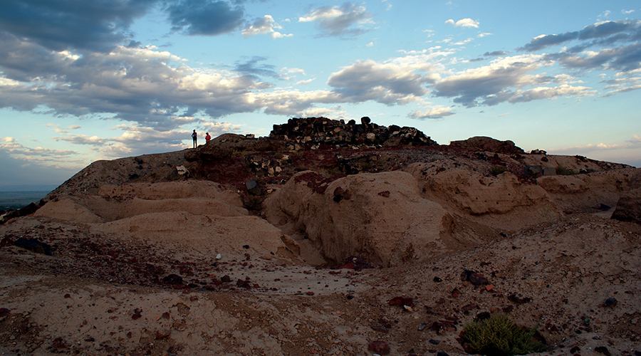
Cover Image Credit: Argishtikhinili viewed from the north (photograph by K. Jakubiak). Buławka, N., et. al., 2026