
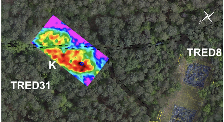
Electrical surveys at a French Neolithic cemetery have uncovered strange stone shapes concealed inside massive earth barrows — including one carved into a human-like silhouette that has puzzled archaeologists for decades.
Deep in a forested plateau in Brittany, France, a set of Neolithic monuments unlike almost anything else in the region has spent thousands of years hiding in plain sight. Long, cigar-shaped mounds of packed earth and silt, some stretching nearly the length of a football field, rise quietly among the pines of Trédion — and until recently, no one really knew what was inside them.
Now, a team of French researchers has used a decades-old but still remarkably effective technique — electrical resistivity mapping — to peer beneath the surface of two of these enormous barrows without digging a single hole. What they found adds a new layer of mystery to a site that has already produced one of the strangest discoveries in French megalithic archaeology: a pair of standing stones shaped like human figures, buried deep inside a mound of dirt.
A Cemetery Hidden in the Forest Since 1986
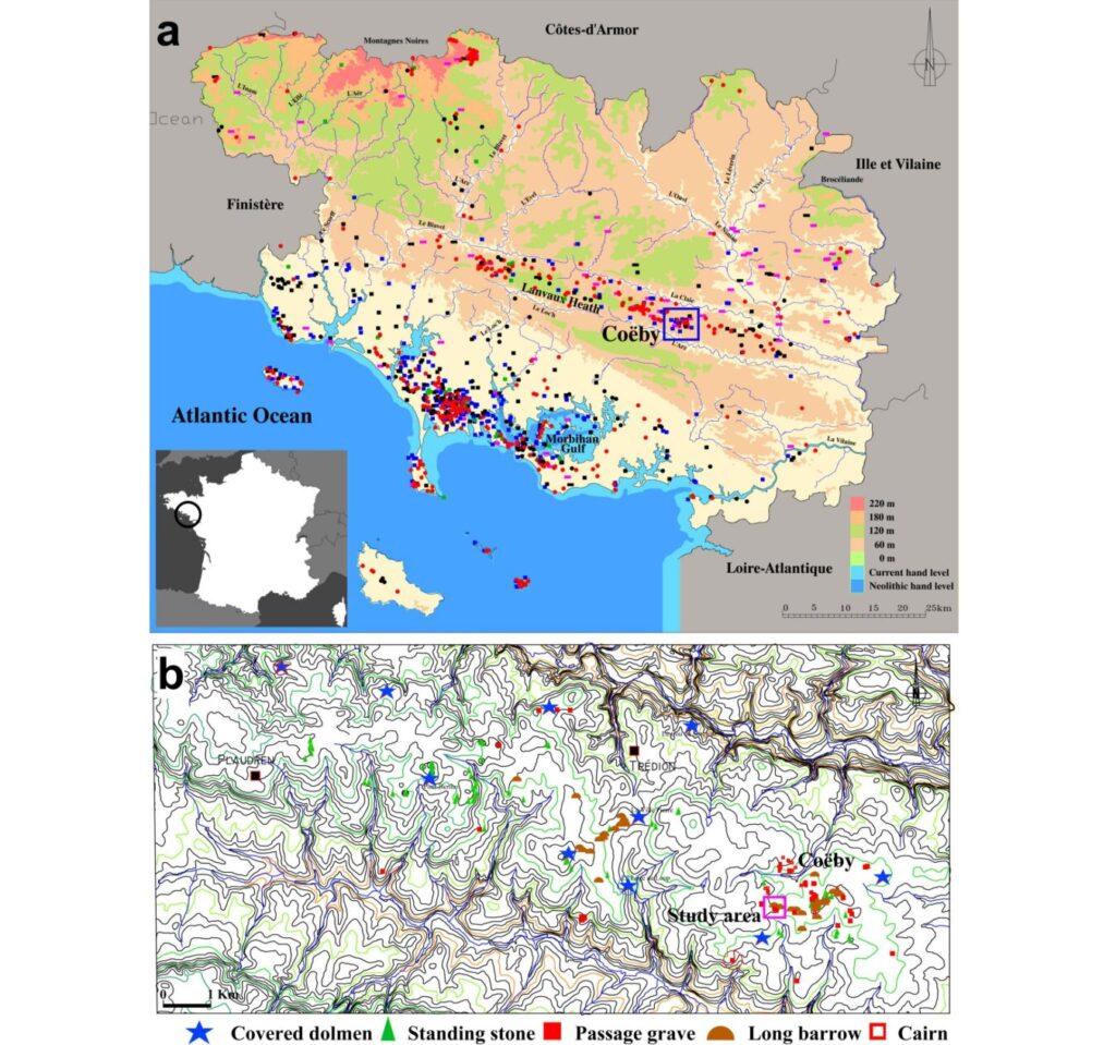
The Coëby Neolithic cemetery, discovered in 1986 in the commune of Trédion, sits in the heart of the Landes de Lanvaux granite massif, about 30 kilometers from France’s Atlantic coast. It’s part of a region so rich in prehistoric monuments that Trédion alone contains 95 documented archaeological sites — dolmens, passage graves, standing stones, and the long, low mounds known as barrows.
Unlike stone cairns, these Coëby barrows are built almost entirely of earth and silt, giving them a soft, elongated profile that researchers have compared to giant cigars or teardrops. They typically run 50 to 80 meters long, 25 to 40 meters wide, and stand up to 1.8 meters tall — impressive enough in scale to raise an obvious question: why go to that much trouble for what looks, from the outside, like an empty pile of dirt?
The Clue That Started It All: Stone Figures Buried in the Mound
The mystery deepened back in the 1990s, when test excavations at one of the barrows, known as TRED36, turned up something unexpected: two roughly carved standing stones with distinctly anthropomorphic — human-like — forms, hidden deep inside the mound rather than displayed on its surface. Excavators also found evidence that the earth filling these barrows had been carried in and dumped basket by basket, along with a peripheral ditch ringing the structure.
That discovery left archaeologists Philippe Gouézin and Vivien Mathé, whose new study appears in the journal Archaeological Prospection, with a nagging question: were the standing stones in TRED36 a one-off oddity, or were similar hidden monuments tucked inside the many other unexcavated barrows scattered across the site?
Reading the Ground Without Digging It Up
Rather than excavate more of these fragile, centuries-old monuments, the team turned to geophysics. Electrical resistivity surveying works by sending a small current through the ground and measuring how easily it flows — wet, compacted soil conducts electricity readily, while buried stone blocks resist it strongly. Mapped out across a survey grid, those differences reveal shapes hidden meters below the surface, essentially letting archaeologists “see” through the earth.
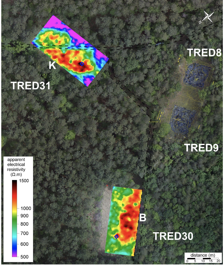
The researchers focused on two long barrows, TRED30 and TRED31, scanning roughly 3,000 square meters of ground at two different depths to build up a picture of what lay beneath. It’s a method that has proven itself over 15 years of similar work on funerary monuments across western France.
What the Scans Found
The results were striking. At both monuments, the survey detected large, elongated zones of unusually high resistance — a signature strongly associated with buried stone — running along the central axis of each mound, exactly where a builder might position something meant to be remembered or protected.
At TRED30, several distinct high-resistance anomalies clustered together, hinting at concentrations of stone blocks sitting at different depths beneath the surface. At TRED31, the pattern was even more pronounced: two intense anomalies near the mound’s central spine, with researchers noting that the larger of the two likely represents not a single stone but several stone features grouped together.
The scans also captured, almost as a side note, just how much damage time and modern land use have inflicted on these ancient structures. A forest access road built after the 1980s survey had sliced directly through one of the mounds, and roughly 20% of TRED30’s original footprint appears to have been leveled and eroded away in recent years — a reminder of how vulnerable even substantial archaeological monuments can be to quiet, incremental destruction.
Echoes of the Passy Tradition
Perhaps the most intriguing part of the study is where it places Coëby on the map of European prehistory. The researchers argue that these earthen giants closely resemble a category of monument known as Passy-type barrows — a tradition of long, standing-stone-topped earthen mounds first identified in the Yonne region of north-central France and known from Normandy down toward Burgundy. Those monuments date to the Middle Neolithic, roughly the middle of the 5th millennium BCE, making Coëby’s barrows contemporaries — separated by hundreds of kilometers — of a funerary architecture rarely documented this far west in Brittany.
That connection matters because it suggests these unassuming mounds of dirt aren’t an isolated local curiosity, but part of a much broader, continent-spanning Neolithic practice of monumentalizing the dead — one where standing stones, whether embedded within a mound or perched on top of it, played a symbolic role archaeologists are only beginning to understand.
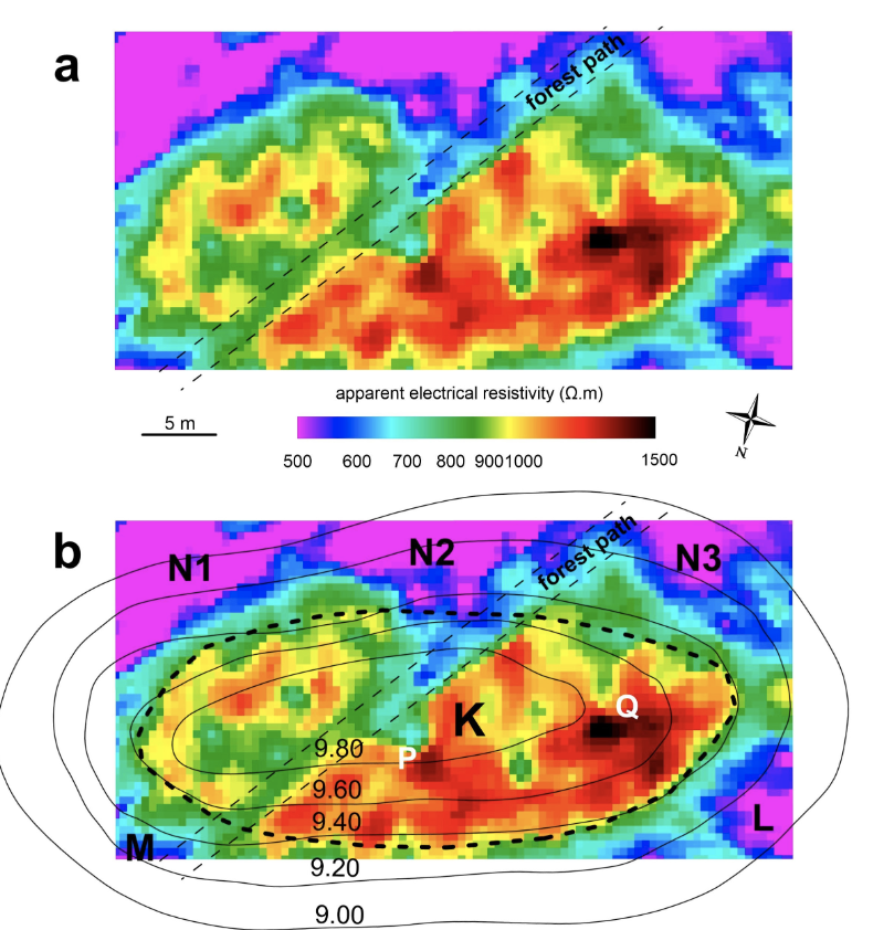
Apparent electrical resistivity map of TRED 31 barrow acquired in 2020 in pole–pole configuration with a mobile electrode spacing of 0.5 m. (b) List of main anomalies. The topography shown here is based on measurements taken in 1989, before the partial destruction of the monument. CAD V. Mathé. Credit: Gouézin, P., and V. Mathé. 2026.
The Questions That Remain
For all that the scans revealed, they couldn’t answer everything. The surveyed areas didn’t extend far enough to confirm whether the barrows were bordered by a perimeter ditch, as at least one other mound at the site was known to have. And while the resistivity data strongly suggests stone structures lie buried within TRED30 and TRED31, the exact shape of those features — whether cists, standing stones, or something else entirely — remains impossible to determine without full excavation.
The researchers are already looking ahead, floating the idea of a more advanced 3D imaging technique called electrical resistivity tomography for future work at the site — a method that has seen major advances in tumulus research over the past 15 years.
For now, the Coëby cemetery keeps most of its secrets literally underground. But thanks to a technique that lets archaeologists see without digging, the outline of those secrets — quite literally — is starting to come into focus.
Gouézin, P., and V. Mathé. 2026. “ Atypical Long Barrows in the Cöeby Neolithic Cemetery (Trédion, Morbihan, France)? The Contribution of Electrical Surveys.” Archaeological Prospection 1–12. https://doi.org/10.1002/arp.70060.
