

Across Arabia, people built a wide range of structures with stone over thousands of years. Burial cairns, enclosures, and larger ritual structures are scattered across the landscape, offering clues about how communities lived and traveled as the region’s climate changed over millennia.
Documenting these sites has traditionally required field surveys or manually tracing features in satellite imagery, both of which are time-consuming approaches.
A team led by Amy Hatton has been testing whether AI can speed up the process and make archaeologists’ jobs easier.
The test area
The research focused on five areas covering approximately 2,500 square kilometers along the southern edge of the Nefud Desert in northwestern Saudi Arabia. Together, the areas extend across roughly 100 by 115 kilometers and contain a mixture of sand dunes, sandy and rocky plains, isolated jebels, and mountain chains. The region is extremely arid today, receiving an average of only 50–100 mm of rainfall per year, although its environmental conditions were different during wetter periods of the past.
The researchers concentrated on areas around jebels, or hills and mountains, because previous archaeological fieldwork suggested that preserved stone structures were particularly common there. The landscape around Jubbah is also archaeologically important, with evidence of human activity extending back hundreds of thousands of years, as well as numerous prehistoric stone structures and rock-art sites.
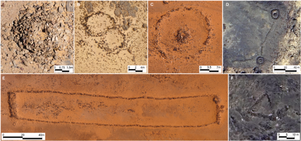
The structures varied in size and appearance, making them a good test of how well AI could recognize different types of archaeological features.
Three different approaches for one purpose
The team trained three different deep learning systems, MA-Net, SegFormer, and U-Net, using satellite imagery from the region. The models automatically identified and outlined stone structures, allowing the researchers to compare the effectiveness of each approach on the same task.
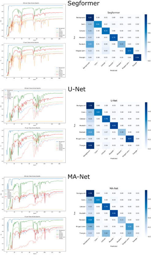
The results showed that MA-Net performed best overall, closely followed by SegFormer. MA-Net achieved an F1-score of 0.897 and an IoU of 0.813, while SegFormer scored 0.894 and 0.808. Although MA-Net had slightly higher scores, SegFormer performed more consistently across different types of structures.
Higher resolution, better results
One of the clearest results was the importance of image resolution. Increasing the resolution from 256 to 512 pixels significantly improved model performance, with MA-Net’s IoU rising from 0.57 to 0.81 and its F1-score from 0.73 to 0.90.
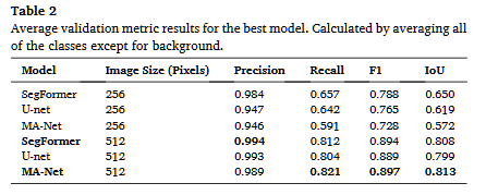
The higher-resolution images did come with a small computational cost. Training time increased from about 10 minutes to 22 minutes per model, but the improvement in detection performance made the higher resolution worthwhile.
Some structures required extra effort
The models did not perform equally well on every archaeological feature. Mustatils were among the easiest structures to detect, with F1 and IoU scores above 0.8 across the models. Their large size and distinctive rectangular shape likely helped the models recognize them.
Cairns were more difficult because they are small and can resemble natural features such as rocks or vegetation in satellite imagery.
The biggest challenges were pendant tombs and triangles. Pendant tombs have complex and variable shapes, while triangles were poorly represented in the training data, with only eight examples. U-Net and MA-Net failed to identify triangles, while SegFormer performed better.
Overall, the models consistently identified four of the six structure types, showing strong potential but also the need for further training.
The Intended Role of AI
The researchers emphasize that on-the-ground surveys and excavations are still essential for confirming what the models identify and collecting detailed evidence that satellite imagery cannot provide.
AI is intended to speed up the early stages of archaeological research. Rather than manually scanning vast amounts of satellite imagery, archaeologists can use trained models to highlight areas that are more likely to contain archaeological structures, then focus their time and resources on investigating those locations.
This could be particularly useful for covering large, remote areas like the 2,500-square-kilometer study region. Faster mapping could also support heritage protection by helping researchers identify vulnerable sites, monitor changes, and detect potential damage from looting, erosion, or development.
Hatton, A., Jambajantsan, A., Breeze, P. S., Guagnin, M., Fisher, M. T., al-Jibreen, F., Alsharekh, A. M., Petraglia, M. D., & Groucutt, H. S. (2026). “Semi-automated detection of Holocene archaeological structures along the southern edge of the Nefud desert.” Journal of Archaeological Science: Reports, 72, 105734. https://doi.org/10.1016/j.jasrep.2026.105734
