
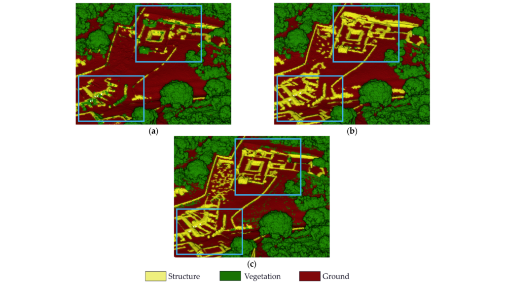
New research shows how artificial intelligence could help archaeologists detect ancient structures hidden under dense vegetation by automatically analyzing massive LiDAR point clouds.
Forests can conceal ancient walls, roads, enclosures, and earthworks beneath trees and undergrowth, making them difficult to recognize from the ground or even through conventional aerial imagery. LiDAR can reveal these features by capturing the structure of the landscape beneath the vegetation, but the resulting datasets can contain millions of points that are difficult to analyze manually.
Artificial intelligence offers a way to process this information on a much larger scale. As a result, researchers are developing machine-learning and deep-learning methods that can automatically classify LiDAR points and identify patterns associated with archaeological structures.
In a new study published in Heritage, researchers Gabriele Mazzacca and Fabio Remondino explore how machine learning and deep learning can automatically classify LiDAR data collected over archaeological sites beneath forest canopies. To do this, they tested a multi-level, multi-resolution approach that separates vegetation from the ground and identifies structures within complex archaeological landscapes.
The study suggests that AI could make it considerably faster to transform enormous LiDAR datasets into maps that archaeologists can actually investigate.
Where the research took place
The researchers tested their approach on three archaeological datasets representing different environments and LiDAR acquisition conditions: San Martino ai Campi in the Italian Alps, Roselle in Tuscany, and Punta Križa in Croatia.
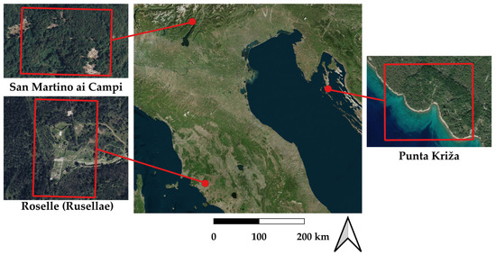
The datasets also differed considerably in point density and sensor characteristics. San Martino and Roselle were both captured by drone at 500–750 points per square meter, while Punta Križa was surveyed from a plane over a decade earlier, at just 16 points per square meter, a difference of nearly 50-fold.
A dense alpine forest, a Mediterranean hillside, and a sparse coastal survey don’t just look different to the naked eye; they produce fundamentally different datasets for an algorithm to learn from. That’s part of why the researchers trained and tested across all three together rather than treating each site in isolation: it highlights one of the major challenges facing archaeological AI, that the quality and diversity of the training data can matter just as much as the algorithm itself.
Training AI to recognize the archaeological landscape
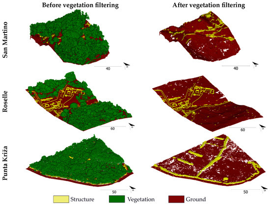
Mazzacca and Remondino developed a multi-level multi-resolution (MLMR) approach that divides the classification problem into stages.
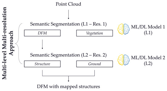
The first stage addresses a relatively straightforward classification question: whether a given point represents vegetation or a non-vegetated area.
Afterward, the second stage examines the remaining points and attempts to distinguish ground from structures.
The researchers tested both a conventional machine-learning algorithm, Random Forest, and a deep-learning architecture known as Point Transformer.
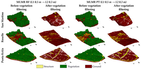
The difference between the two approaches became particularly clear during the structure-classification stage. The Point Transformer performed substantially better than Random Forest, demonstrating the potential of deep learning to recognize complex spatial patterns within archaeological point clouds.
This advantage is particularly important because archaeological structures rarely retain perfect geometric forms. Buried or partially preserved walls may appear as fragmented point patterns, erosion can distort ancient enclosures, and vegetation may obscure portions of a structure. Deep-learning models can analyze relationships between neighboring points and learn these complex spatial patterns directly from the data, rather than relying primarily on manually designed geometric features.
Teaching the AI from its own mistakes
The two-stage design in Figure 1 isn’t itself new — Mazzacca and colleagues have used similar multi-level pipelines in earlier work. What sets this study apart is how the second stage is trained.
In previous versions of this approach, both stages learned from the same source: clean, manually verified ground-truth labels. That works well in the lab, but it creates a mismatch in the real world. Once the pipeline is actually deployed, the second stage doesn’t receive clean data. It receives whatever the first stage predicted, mistakes included.
To close that gap, the researchers trained the second stage on the first stage’s actual predictions rather than on the ideal labels. In effect, the structure-detection model learns to work with a noisier, more realistic input, the same kind of imperfect data it will encounter when running on a new site with no human double-checking its work.
Thanks to this approach, it removes a step that used to require a person: manually correcting the output between stages before moving on. Without that correction step, the whole pipeline can run start to finish on its own, which is what makes it realistic to apply across large, unmapped forested landscapes rather than just curated test sites.
Defining and interpreting IoU
IoU will be used extensively in the following sections. Therefore, this subsection provides an overview of the metric for readers with limited background knowledge, explaining what IoU is and how it influences the results presented later in the study.
IoU (Intersection over Union) is a common metric used to measure how closely an AI-generated prediction matches a verified reference.
For example, if an AI system identifies the location of an ancient wall by drawing a boundary around it, that boundary can be compared with the outline established by an expert. IoU calculates the proportion of the area shared by both shapes relative to the total area covered by either shape. A score of 100% indicates an exact match, while 0% means the two regions do not overlap at all.
An IoU score in the 70% range is generally considered strong for a challenging, real-world classification problem. Identifying ancient structures that are weathered, partly buried, and scattered across a cluttered forest environment is considerably more difficult than recognizing a simple, clearly defined geometric object in a clean image. The structure category in this study consistently achieves scores in the 50% range, highlighting how much more difficult it is to accurately identify these features compared with broader categories such as “vegetation” and “non-vegetation.”
More detailed data does not always mean better results
A key finding concerns the effect of LiDAR resolution. The researchers evaluated datasets at resolutions of 0.3, 0.5, and 1.0 meters. While higher-resolution data are generally expected to provide more detailed information for AI-based archaeological analysis, the results demonstrate that finer resolution doesn’t reliably pay off, and can even work against the classes archaeologists care about most.
The end-to-end Point Transformer achieved an average IoU of 76.65% at 0.3-meter resolution, compared with 75.14% at 0.5 meters and 70.08% at 1 meter. But for the structure class specifically, the category of greatest archaeological interest, accuracy actually declined slightly at the finer resolution, dropping from 51.92% IoU at 0.5 meters to 51.42% at 0.3 meters. This came despite the 0.3-meter run requiring roughly four times the training time: 8 hours and 33 minutes, compared with just 2 hours and 4 minutes at 0.5 meters.
The results therefore show that higher resolution does not necessarily provide a proportionate improvement in performance, and in this case the extra detail came at a cost rather than a gain for structure detection. The researchers found the 0.5-meter setup to be the most cost-effective option overall. For archaeological researchers working with large-scale LiDAR datasets, this trade-off between accuracy and computational efficiency could therefore be a critical consideration.
Does the extra complexity even pay off?
The MLMR pipeline described above is the more sophisticated approach: it splits the problem into two specialized stages, filtering vegetation first and hunting for structures second. The researchers also tested a simpler alternative, an “end-to-end” version of the same Point Transformer model that predicts everything in a single pass, with no staging at all.
The results were not what you’d expect. The end-to-end model, run at 0.5-meter resolution, slightly outperformed the best MLMR configuration on both overall accuracy and on the harder structure-detection task specifically, while taking roughly half the training time.
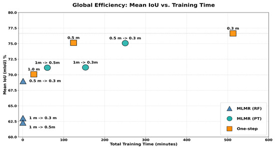
In other words, the carefully engineered two-stage pipeline didn’t buy the researchers better results. The plainer, single-pass model got there faster and just as accurately, sometimes more so.
That doesn’t make MLMR pointless. Its staged design still offers something the simpler model can’t: archaeologists can check the vegetation-filtering step before the structure-detection step ever runs, catching errors early instead of only at the end. For teams processing thousands of square kilometers, that kind of checkpoint may be worth more than a small speed advantage. But for a single site where speed and raw accuracy matter most, the researchers’ own results suggest the simpler tool is the better one.
Two different kinds of mistakes
A similar overall score can hide very different behavior underneath it, and that’s exactly what happened here.
MLMR turned out to be the more cautious of the two methods. Because it filters out vegetation before it ever looks for structures, anything that gets mistakenly swept into the “vegetation” pile at that first stage is gone for good, structure or not. The result is a model that’s more conservative: when it does flag something as a structure, it’s usually right, but it also quietly misses real structures more often, filtered out before it had a chance to see them.
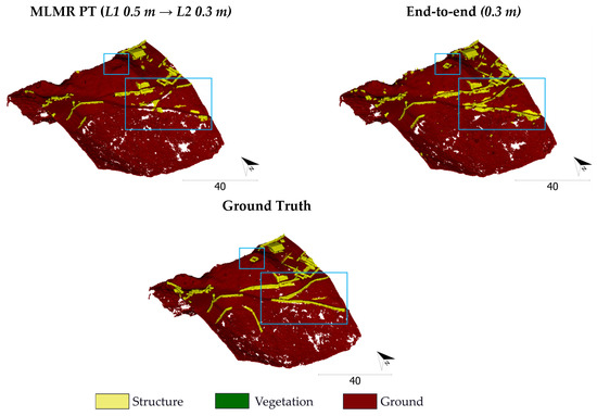
The end-to-end model makes the opposite trade. Without a filtering stage clearing the way first, it catches more of the real structures in the data. But that comes at the cost of more false positives, flagging noise or terrain features as structures that aren’t actually there.
Neither error is free. For an archaeologist doing a first-pass survey of a large area, missing a real structure is often the costlier mistake; a false positive gets ruled out on a site visit, but nothing sends anyone to check ground that was never flagged. For a smaller, more targeted excavation project already zeroed in on a specific site, wading through extra false leads might be the more tolerable trade-off. Which method suits a project may come down less to raw accuracy and more to which kind of mistake a research team can better afford.
Why the Research Matters
The significance of this study extends beyond the performance of a single AI model. Archaeology is rapidly becoming a data-intensive discipline, with satellite imagery, LiDAR, drone surveys, photogrammetry, geophysical surveys, and digital excavation records generating enormous quantities of information. As the volume of available data continues to grow, the challenge is increasingly not simply collecting archaeological information, but identifying meaningful patterns within it.
This is particularly true in forested regions, where archaeological remains can stay hidden beneath dense vegetation for centuries and conventional survey methods struggle to reveal what lies beneath the canopy. Rather than manually examining entire landscapes, archaeologists could use AI to flag areas that warrant closer investigation, then bring in historical maps, satellite imagery, and targeted fieldwork to confirm whether a suspected structure is genuinely archaeological.
That points toward a practical division of labor: AI searches the data at a scale no team could manage by hand, while archaeologists interpret the evidence and decide where to dig. What once required extensive manual surveying could increasingly begin with an automated pass across vast areas, directing fieldwork toward the places most likely to hold something real.
For centuries, forests may have concealed traces of the people who once lived there. With LiDAR and artificial intelligence, those traces are becoming easier to find.
Mazzacca, G., & Remondino, F. (2026). Under-Canopy Archaeological Mapping Using LiDAR Data and AI Methods. Heritage, 9(4), 134.
https://doi.org/10.3390/heritage9040134
