
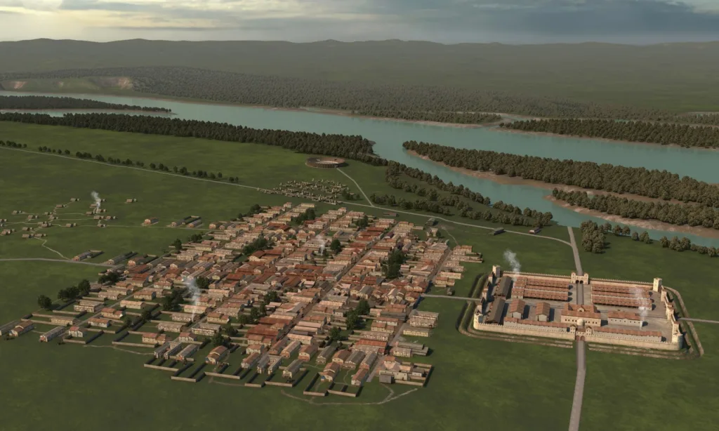
Beneath farmland near the Danube in Austria, archaeologists have mapped the remains of a previously unknown Roman city with a regular street grid, residential blocks, and an amphitheater large enough to hold around 8,000 spectators. The planned settlement covered roughly 25 to 30 hectares and developed beside a much smaller auxiliary fort, giving researchers an unusual glimpse of Roman urban expansion along the empire’s northern frontier.
The city appears to have flourished for only about a century before it was abandoned around AD 180. Researchers are now investigating whether the settlement could be Claudivium, a Roman town mentioned by Ptolemy but later lost from the historical record.
A city that had been hiding in plain sight
The archaeological site at Stein was not entirely unknown. Scholars had collected material from the surrounding fields since the 1970s, and about 2,000 metal objects and 150 fragments of terra sigillata pottery accumulated over roughly five decades of fieldwalking. What remained unclear was the scale and character of the settlement beneath the fields.
A breakthrough came in 2017, when vegetation marks exposed the corner of an unknown Roman auxiliary fort and one of its towers. Researchers subsequently examined aerial photographs and began systematic magnetic and ground-penetrating radar surveys.
Those investigations transformed the picture.
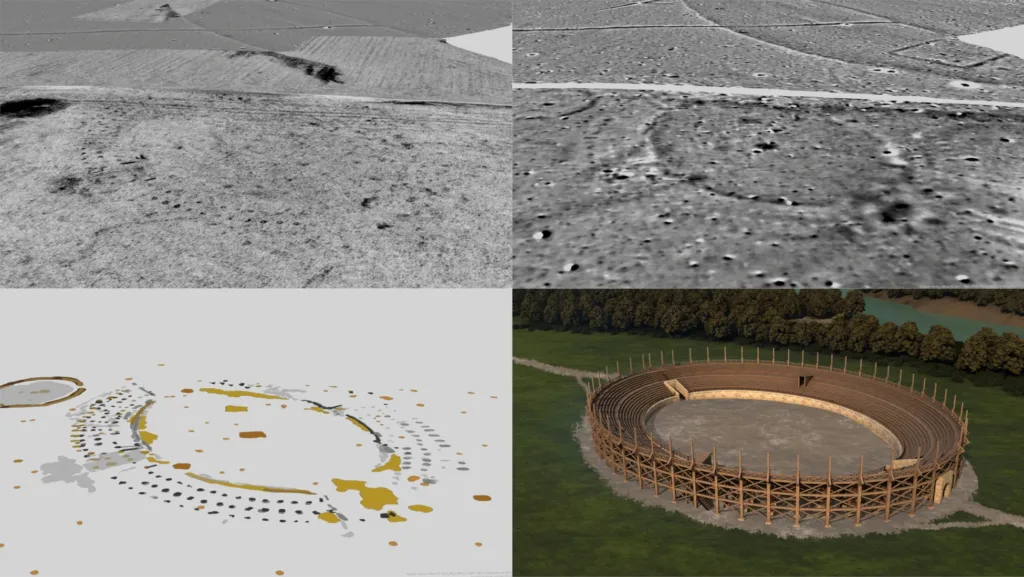
Since 2021, researchers have surveyed roughly 100 hectares with motorized magnetometers. Ground-penetrating radar covered about 50 hectares and investigated deposits to calculated depths of around 2.5 to 3 meters. Combining the two methods allowed researchers to overcome difficult geological conditions caused by alternating gravel and sandy deposits beneath the site.
The resulting maps revealed a regular street system dividing the settlement into distinct urban blocks, or insulae. Significantly, the streets and neighborhoods follow the orientation of the adjacent military fort, indicating that the settlement developed according to an organized plan rather than through gradual, irregular expansion.
An 8,000-seat amphitheater beside a fort for 500 soldiers
The scale of the city is what makes Stein especially unusual. According to University of Innsbruck archaeologist Gerald Grabherr, researchers have mapped a settlement of about 25 to 30 hectares beside an auxiliary fort that accommodated approximately 500 soldiers.
He says no comparable case is currently known in the Roman Empire in which such a large, formally planned settlement developed around a fort of this size.
The most conspicuous structure detected so far is an amphitheater with an estimated capacity of around 8,000 people—comparable in size, according to the research team, with the amphitheater at the major Roman military center of Carnuntum.
Roads leading out of the settlement also passed through extensive burial grounds. A particularly large cemetery to the northwest contains graves, funerary monuments and burial mounds, some of substantial dimensions. These features, together with the amphitheater and planned street network, strengthen the interpretation of Stein as an urban center rather than a conventional settlement serving a nearby military post.
Excavations at selected locations have added another unusual detail. Three Roman drying installations found on the southern edge of the settlement may have belonged to a brewing complex, although that interpretation remains provisional.
A thriving city abandoned around AD 180
The settlement appears to have had a remarkably short life.
Current evidence places its beginnings around AD 80. A series of approximately 643 coins indicates that the flourishing settlement was abandoned abruptly around AD 180. The researchers have found no archaeological evidence for widespread destruction, leading them to argue that the departure may instead have resulted from an organized withdrawal.
That timing coincides with a major shift along Rome’s northern frontier.
During the Marcomannic Wars of AD 166–180, Rome fought Germanic groups north of the Danube. The Stein settlement occupied a strategically important position near a Danube crossing and the Aist valley, which provided one of the shortest routes toward the Moldau region. Archaeologists have also identified several Roman military camps north of the Danube, evidence of substantial troop activity in the wider area.
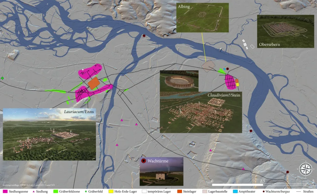
After Marcus Aurelius died in AD 180, his son Commodus ended the wars and altered Rome’s strategy along the Danube frontier. The researchers propose that this reorganization contributed to the abandonment of Stein while military power increasingly concentrated at Lauriacum, modern Enns, only around six kilometers away.
Lauriacum subsequently expanded dramatically. Similar fibulae and bronze-working tools found at both settlements suggest that some craftspeople and other inhabitants may have moved west after Stein was abandoned. Around 50 years later, Lauriacum had grown to roughly three times the size of the former city, while stone from the deserted settlement at Stein was being reused as building material.
Could the lost city be Claudivium?
Its ancient name remains the central unresolved question.
Ptolemy recorded a settlement called Claudivium in the second century AD. According to the Innsbruck researchers, the coordinates he supplied correspond surprisingly well with the location of the city at Stein. Ptolemy also associated the same location with a river arriving from the north, potentially identifiable as the Aist.
The chronology provides another intriguing fit. Claudivium disappears from later sources, while archaeological evidence indicates that Stein ceased functioning as a settlement around AD 180.
Yet the scientific paper remains deliberately cautious. Its authors describe Claudivium as a possibility rather than an established identification, concluding that continued research may eventually reveal the name of the newly discovered town.
For now, what lies beneath the fields at Stein is significant even without a name. Geophysics has exposed the footprint of a large, deliberately planned Roman city, built at a strategically sensitive moment on the Danube frontier and abandoned after barely a century.
Wallner, M., Löcker, K., Hinterleitner, A., Gallistl, J., Schiel, H., Schlögel, I., Totschnig, R., Trausmuth-Wallner, T., Traxler, S., Thysell, E., Grabherr, G., Kainrath, B., Klammer, J., Hemmers, C., & Pollhammer, E. (2025). Claudivium? How to discover a new Roman town? ArcheoSciences, 49(1), 219–222. https://doi.org/10.4000/14nru
