High in the rugged mountains along the modern border between northern Portugal and Galicia in Spain, thousands of ancient stone mounds have endured for millennia. These prehistoric funerary monuments form one of the densest concentrations of megalithic structures in Europe, silently marking the landscape for over 6,000 years. For decades, archaeologists have tried to understand why these monuments were built in such specific locations. A new scientific study now offers a powerful answer, revealing that their placement was far from random.
A Landscape Filled With Meaning
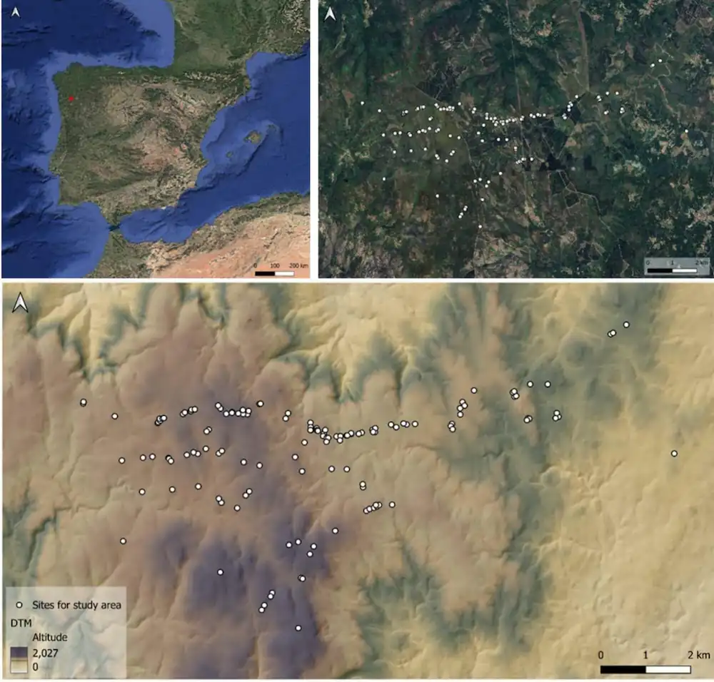
The research focuses on the mountainous region of Serra do Laboreiro, a natural frontier where hundreds of burial mounds stretch across high plateaus and ridges. Rising between 700 and 1,300 meters above sea level, this area acts as a natural laboratory for understanding prehistoric human behavior.
Many of these monuments have never been excavated, leaving their internal structures and exact ages uncertain. Instead of digging into the ground, researchers looked outward, studying how these structures relate to the surrounding terrain. This approach, known as landscape archaeology, seeks to understand how ancient people interacted with and shaped their environment over time.
Technology Unlocks the Past
To begin, scientists used LiDAR technology, which sends laser pulses from aircraft to map the ground in high detail, even through dense vegetation. This allowed them to verify the exact positions of the monuments and remove errors from earlier records. From an initial set of 269 locations, only 178 were confirmed as genuine prehistoric mounds after duplicates and uncertain cases were eliminated.
This step was crucial. Without accurate data, identifying meaningful patterns would not have been possible. Once confirmed, each monument became part of a broader effort to decode how ancient communities selected these sites.
📣 Our WhatsApp channel is now LIVE! Stay up-to-date with the latest news and updates, just click here to follow us on WhatsApp and never miss a thing!!
Testing the Role of the Landscape
The research team analyzed eight key features of the landscape, including elevation, slope, proximity to ridges, distance to rocky outcrops, and the extent of the visible horizon. To determine whether these features influenced monument placement, they compared real locations with nearly one thousand randomly generated points across the same region.
The results showed a clear pattern. Seven of the eight variables demonstrated strong statistical significance, proving that the monuments were deliberately placed rather than randomly scattered.
The Hidden Pattern Behind the Monuments
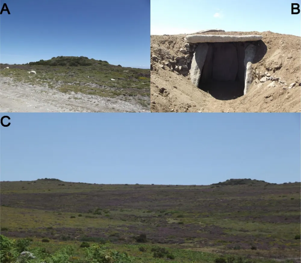
What the researchers uncovered is not a single rule, but a consistent spatial logic. The monuments are not scattered randomly across the mountains. Instead, they cluster in elevated areas, near ridgelines, rocky outcrops, and natural boundaries, often in places where the horizon is wide and clearly defined. Statistical analysis confirms that this pattern is highly unlikely to be accidental.
But the most revealing detail lies in what does not matter. Contrary to long-standing assumptions, the total area visible from each monument plays no significant role in their placement. This suggests that prehistoric communities were not trying to oversee vast territories. Rather, they were selecting locations that already held meaning within the landscape—points where natural features, such as ridges and horizon lines, shaped how the land was perceived and navigated. In this sense, the monuments did not create a network across the terrain; they made an existing one visible, transforming geography into a cultural and social map.
Why Height Matters Most
Among all the factors studied, elevation stood out as the most important. The monuments are consistently located at higher altitudes than would be expected by chance.
This suggests that prehistoric communities intentionally chose elevated areas, possibly because these locations held symbolic or practical importance. High ground offers visibility, prominence, and a sense of permanence, all of which may have been meaningful for marking burial sites.
Slope also played a role, indicating that not just any hillside was suitable. The terrain had to meet certain conditions, reflecting a careful selection process rather than convenience.
The Power of the Horizon
One of the most revealing findings involves the concept of the horizon. The study shows that monuments are often placed in locations with wide, open views of the surrounding landscape. These are places where the line between land and sky is clearly visible.
Interestingly, while the breadth of the horizon was important, the total visible area from a monument was not. This challenges earlier theories that these structures were positioned to oversee large territories.
Instead, researchers suggest that ancient builders were drawn to specific visual landmarks rather than broad visibility. Ridges, rock formations, and natural boundaries appear to have guided their choices, acting as reference points within the landscape.
Marking Territory, Not Just Burying the Dead
The findings point to a deeper purpose behind these monuments. Rather than simply serving as burial sites, they likely functioned as markers within a lived and traveled landscape.
By placing monuments near ridges, rocky outcrops, and watershed boundaries, prehistoric communities may have been defining territories and reinforcing their presence in the environment. These structures turned natural features into cultural landmarks, creating a shared spatial understanding of the land.
A Landscape Shaped Over Time
The study also highlights an important complexity. These monuments were not all built at once. They span thousands of years, meaning that different communities may have followed different strategies.
Some sites form clusters that developed over long periods, while others stand alone in seemingly less prominent locations. This diversity reflects the complexity of human decision making, which cannot be reduced to environmental factors alone.
Some sites form clusters that developed gradually, while others stand alone in less prominent locations. This variation shows that human decisions were not strictly determined by environmental factors. Instead, people adapted to and reinterpreted the landscape over time.
Archaeological evidence supports this dynamic view. In some regions, layers of ash and charcoal beneath monuments indicate that vegetation was deliberately cleared using fire before construction. Other sites show signs of repeated use, abandonment, and reuse over centuries. Each monument is not a single moment in time, but part of an evolving sequence of human activity.
A Wider European Pattern
The patterns observed in Serra do Laboreiro are not unique. Similar behaviors have been identified across western Europe, where megalithic monuments often appear in clusters and are reused over long periods.
These findings place the Serra do Laboreiro monuments within a broader European context. Similar patterns of accumulation and reuse have been observed in other regions, where burial sites became focal points for long-term territorial organization. Across western Europe, from the Iberian Peninsula to northern France, megalithic landscapes reflect a shared tendency to anchor social identity in physical space.
Limits and New Questions
Despite its insights, the study acknowledges its limitations. Without precise dating for most monuments, researchers must treat them as if they were built at the same time, even though they span millennia. This makes it difficult to fully capture how patterns changed over time. Future research will aim to integrate more detailed chronological data and qualitative analysis to deepen understanding.
Even so, the implications are clear. The placement of these ancient monuments was not accidental. It reflects a complex interaction between human intention, environmental constraints, and cultural meaning. Early communities were not simply reacting to their surroundings; they were actively shaping them, turning landscapes into enduring expressions of identity and presence.
Today, the stone mounds of Serra do Laboreiro still rise against the horizon, silent but deliberate. Thanks to modern technology and careful analysis, their hidden patterns are beginning to speak, offering a glimpse into how our ancestors understood the world and their place within it.
Lima e Silva, D., Carrero-Pazos, M., Lara-Piñera, F., Fonte, J., & Vilas-Estévez, B. (2026). Spatial insights of the tumular phenomenon in Serra do Laboreiro region (NW Iberian Peninsula). Journal of Archaeological Science: Reports, 72, 105730. https://doi.org/10.1016/j.jasrep.2026.105730
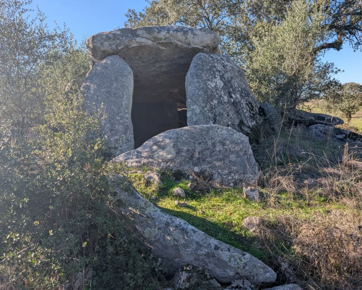
Cover Image Credit: Anta Grande da Comenda da Igreja. Prehistoric Portugal