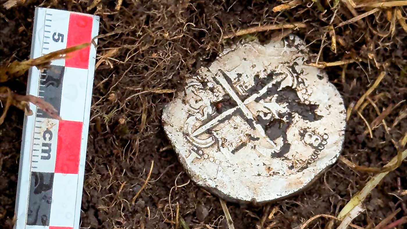
A 440-year-old silver coin has done what decades of archaeological uncertainty could not: it has pinpointed the exact founding location of one of the most infamous failed colonies in South American history—Puerto del Hambre (“Port Famine”) in the Strait of Magellan.
The discovery offers rare physical confirmation of historical accounts dating back to 1584, when Spanish navigator Pedro Sarmiento de Gamboa attempted to establish a strategic settlement at the southern tip of the Americas.
A Coin That Solved a 16th-Century Puzzle
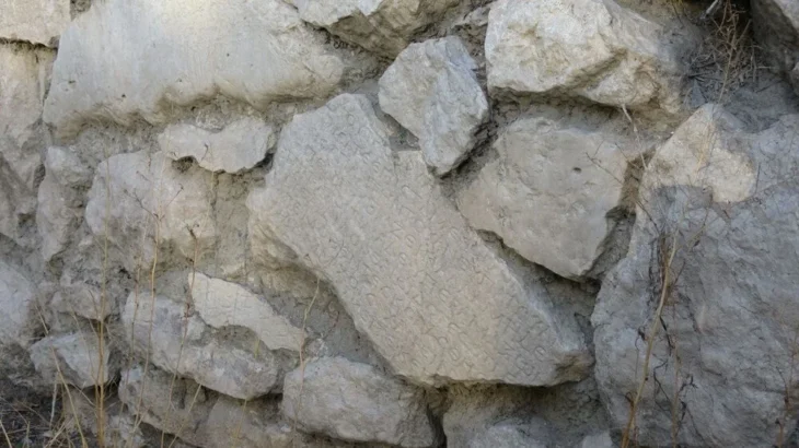
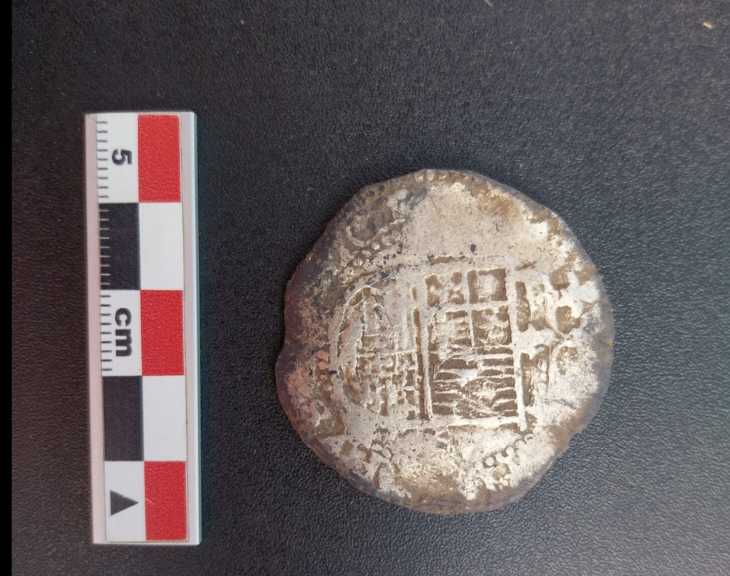
The coin—an eight reales silver piece minted during the reign of Philip II—was uncovered at the archaeological site of Rey Don Felipe, the original name of the ill-fated settlement.
What makes the find exceptional is not just its age, but its precise placement.
Researchers confirmed that the coin was deliberately deposited during the city’s founding ritual, a symbolic act described in early colonial chronicles. According to those accounts, Sarmiento de Gamboa placed a coin beneath the first stone of a church to invoke royal authority and divine protection over the new settlement.
📣 Our WhatsApp channel is now LIVE! Stay up-to-date with the latest news and updates, just click here to follow us on WhatsApp and never miss a thing!!
Now, for the first time, archaeology has verified that narrative.
“It was found exactly where historical sources said it would be—on a stone surface within the small church structure,” explained project lead Soledad González Díaz, a researcher at the University Bernardo O’Higgins.
That level of precision transforms the coin from a simple artifact into something far more powerful: a fixed reference point for reconstructing the entire layout of the lost city.
Reconstructing a Lost Colonial Settlement
The implications extend well beyond a single object.
By anchoring the exact location of the church, researchers can now begin to map the surrounding urban features described in 16th-century documents—houses, storage facilities, and defensive structures that once formed the settlement.
“This is not an isolated object,” noted archaeologist Simón Urbina. “It directly interacts with written historical testimony, allowing us to connect narrative and landscape in a very concrete way.”
In practical terms, the coin functions like a geographical key, unlocking the spatial organization of Rey Don Felipe after centuries of ambiguity.
Technology Meets Archaeology
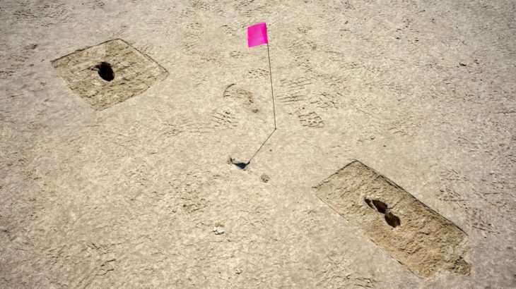
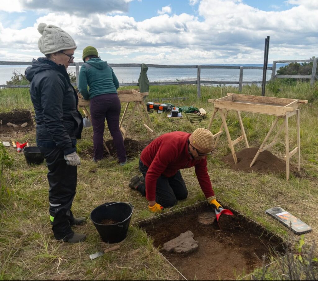
The discovery was made possible through a carefully planned, non-invasive survey strategy.
Instead of large-scale excavation, the research team used high-precision geolocation systems and advanced metal detection technologies to scan the terrain. By mapping signal intensity and depth, they identified anomalies beneath the surface—one of which turned out to be the coin.
“We detected a very strong signal, but at that stage we didn’t know what it was,” explained archaeologist Francisco Garrido of Chile’s National Museum of Natural History. “Only after targeted excavation did we realize its significance.”
This approach highlights a broader shift in modern archaeology: less digging, more data-driven precision.
The Global Story Behind the “Real de a Ocho”
The coin itself carries a story that extends far beyond Patagonia.
Known as the “Real de a Ocho” or “piece of eight,” this silver currency was one of the first truly global monetary systems. Minted primarily in Potosí (modern Bolivia), it circulated across Europe, the Americas, and Asia—accepted even in markets as distant as China and the Philippines.
Its design reflects imperial authority: one side bears the Jerusalem cross, while the other features the coat of arms of Philip II.
In this context, the coin was more than symbolic. It represented the economic and political reach of the Spanish Empire at its peak—a global system anchored, quite literally, in the foundations of a fragile colonial outpost.
The Tragic History of Puerto del Hambre
The settlement itself tells a darker story.
Founded on March 25, 1584, Rey Don Felipe was part of Spain’s effort to control the Strait of Magellan, a crucial maritime corridor linking the Atlantic and Pacific Oceans long before the Panama Canal existed.
But the colony quickly descended into catastrophe.
Harsh climatic conditions, isolation, and lack of supplies led to widespread starvation. Within a few years, the settlement was abandoned, and most of its inhabitants perished. English navigator Thomas Cavendish later encountered the site in 1587 and renamed it “Port Famine”, a name that has endured ever since.
Today, the site stands as a stark reminder of the human cost of early colonial expansion—and the limits of imperial ambition in extreme environments.
Bridging Text and Landscape
For historians and archaeologists alike, the significance of the discovery lies in its ability to bridge written history and physical evidence.
Philologist Joaquín Zuleta emphasized that the find creates a direct link between archival descriptions and the modern landscape of the Strait of Magellan.
“It allows us to align historical documents with archaeological reality in a way that is rarely this precise,” he noted.
That alignment is crucial not only for understanding this particular site, but also for refining broader interpretations of early colonial settlements in South America.
A Small Object, A Major Breakthrough
At just a few centimeters in diameter, the coin might seem modest.
Yet its impact is anything but.
By confirming the exact location of the founding ritual, it provides a foundation—both literal and intellectual—for future research into one of the most dramatic episodes of early colonial history.
Sometimes, it turns out, the smallest objects carry the weight of entire cities—and centuries of unanswered questions.
Centro de Estudios Históricos y Humanidades
Cover Image Credit: Richard Bezzaza -Centro de Estudios Históricos y Humanidades via Facebook