
New research at Haughey’s Fort reveals a vast Bronze Age landscape with 204 possible buildings, metalworking, feasting, long-distance exchange, and ritual activity.
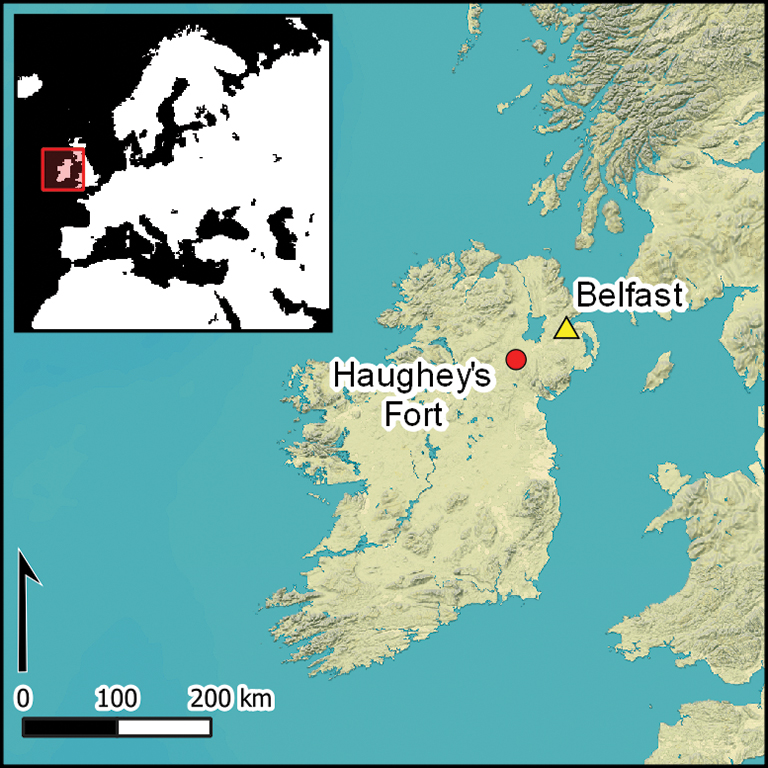
Long before Navan Fort became famous in Irish tradition as the royal seat of ancient Ulster, another center of power was already taking shape in the same landscape. Around 1200 BC, Haughey’s Fort near Armagh in Northern Ireland appears to have developed into one of the most complex Late Bronze Age sites yet identified in north-west Europe.
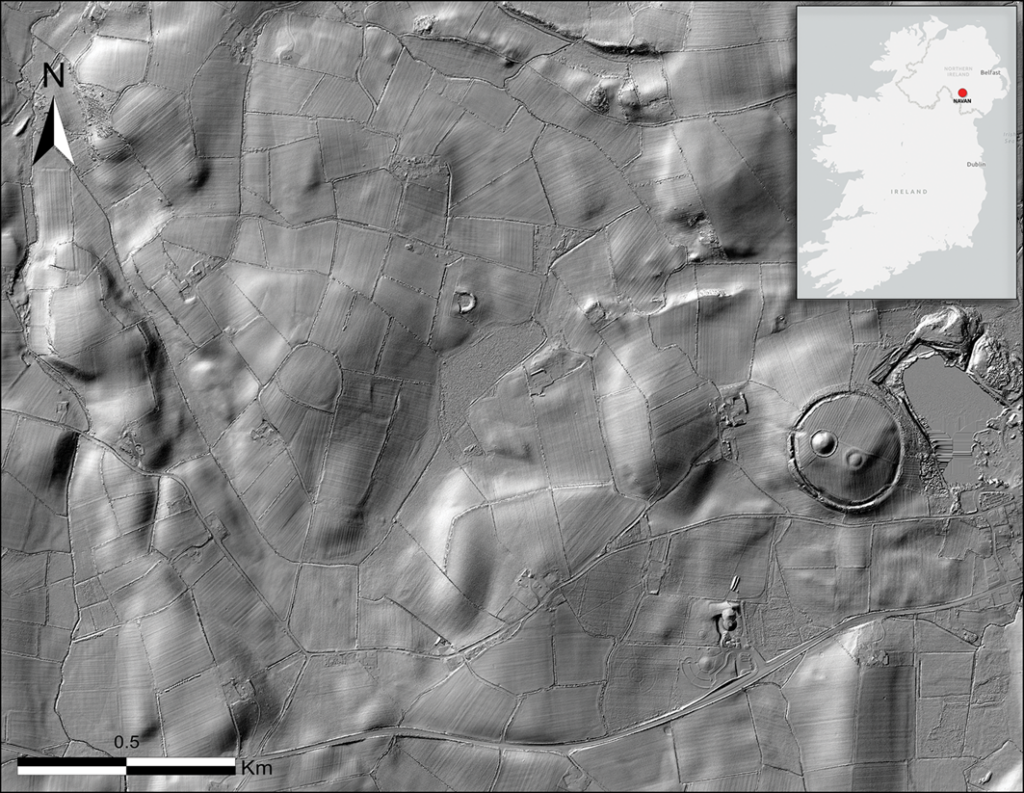
A new study published in Antiquity argues that Haughey’s Fort was not simply a hillfort or ceremonial enclosure. Combining lidar, geophysical survey, targeted excavation, and a reassessment of earlier finds, archaeologists James O’Driscoll of the University of Glasgow and Patrick Gleeson of Queen’s University Belfast identify the site as a large, highly organized complex where settlement, metalworking, feasting, ritual activity, and long-distance exchange came together.
The result is a different picture of Bronze Age Ireland: not only scattered farmsteads and isolated monuments, but a nucleated landscape capable of drawing people, resources, and prestige goods across considerable distances.
A settlement larger than expected
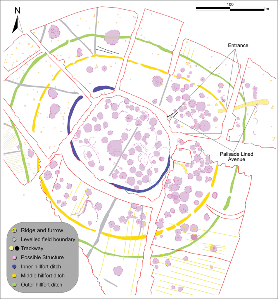
Haughey’s Fort was already known as a substantial Late Bronze Age hillfort. Earlier excavations revealed three broadly concentric enclosures covering about 9.29 hectares. A large oak fragment from the inner ditch produced a felling date of 1152–1116 BC, placing major activity at the site in the Late Bronze Age.
📣 Our WhatsApp channel is now LIVE! Stay up-to-date with the latest news and updates, just click here to follow us on WhatsApp and never miss a thing!!
The new research greatly expands that picture. Geophysical surveys identified more than 204 anomalies interpreted as possible circular wooden structures, most of them between 7 and 9 meters in diameter — consistent with Bronze Age house sizes in Ireland. Three much larger circular buildings, measuring roughly 22, 23, and 30 meters across, may have served communal, ritual, or institutional functions rather than ordinary domestic use.
The authors are cautious: without large-scale excavation, it is difficult to prove that all 204 possible structures stood at the same time. But their density, layout, and association with craft and ceremonial activity make Haughey’s Fort one of the strongest candidates for proto-urban development in Bronze Age Ireland or Britain.
This does not mean Haughey’s Fort was a “city” in the Mediterranean sense. There is no evidence for stone streets, formal administrative buildings, or a classical urban plan. Its architecture was largely wooden, and much of it survives only as buried traces. But by the standards of temperate Bronze Age Europe, the site shows several urban-like traits: scale, settlement density, building diversity, specialized production, long-distance contacts, and monumental boundaries.
Craft, feasting, and high-status production
Excavations inside Haughey’s Fort had already uncovered pits, postholes, carbonized grain, pottery, fragments of bronze and gold objects, casting debris, and waste from craft production. These finds suggest the site was not merely occupied, but economically active.
The evidence points especially to bronze and gold working. Some scholars have argued that Haughey’s Fort may have functioned as a regional center for craft production, including the manufacture of local versions of imported continental objects. The presence of thousands of animal bones also indicates large-scale feasting or repeated communal gatherings.
That combination matters. In Bronze Age societies, metalworking was not just a technical activity. Bronze weapons, gold ornaments, and imported prestige goods were tied to status, exchange, diplomacy, ritual display, and possibly martial identity. At Haughey’s Fort, production and ceremony appear to have been closely linked.
Imported objects and far-reaching connections
The wider landscape around Haughey’s Fort has produced objects that point beyond Ireland. The Tamlaght Hoard, found near the edge of a bog about 500 meters southwest of the fort, included an imported Fuchsstadt-type bowl, a Jenišovice-type cup, a bronze ring likely from Central Europe, and a leaf-shaped sword. The study notes that the bowl and cup are the only known examples of these artefact types in Atlantic Europe.
An Iberian-style neck ring and a socketed axehead were also recovered near the Creeveroe Earthworks. These finds do not prove direct travel from Iberia or Central Europe to Armagh, but they do show that the community was plugged into exchange networks stretching far beyond the local region.
For archaeologists, that is one of the strongest signs that Haughey’s Fort was more than a defended settlement. It was a place where rare objects, technical knowledge, and social authority circulated.
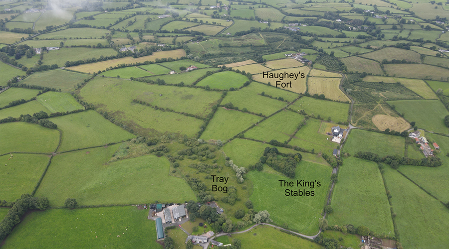
The King’s Stables: a ritual pool below the fort
One of the most striking parts of the complex lies just below Haughey’s Fort. The King’s Stables is an artificial pool about 25 meters in diameter and sunk roughly 4 meters below the ground surface. Earlier excavations found that it filled with water soon after construction, preserving organic material in waterlogged conditions.
The deposits from the pool were unusual: fragments of moulds for leaf-shaped swords, partly articulated animal remains, red deer antlers, canine remains, and human bone, including part of a skull. The study interprets the King’s Stables as a ritual focus, likely connected to votive deposition and perhaps sacrifice.
New survey work strengthens the link between the pool and Haughey’s Fort. The researchers identified an 87-meter-long, 5-meter-wide palisade-lined avenue running from the hillfort entrance toward the King’s Stables. This was not a casual path. Its architecture suggests a formal route, probably used for processions or controlled movement between the settlement and the ritual pool.
The two places seem to have had different roles. Haughey’s Fort yielded evidence for production and feasting, while the King’s Stables contained mould fragments and unusual animal and human remains, suggesting deposition or ritual decommissioning rather than everyday manufacture.
A 109-hectare monumental enclosure
The biggest revision concerns the Creeveroe Earthworks. Previously interpreted as a boundary separating parts of the landscape, the earthworks are now understood as part of a much larger enclosure around Haughey’s Fort.
Using lidar and gradiometry, the researchers argue that the Creeveroe Earthworks formed a 109-hectare outer enclosure. That would make the complex one of the largest known hillfort landscapes in Ireland and Britain.
The enclosure did more than mark space. Burial monuments and metalwork deposits clustered along its perimeter, suggesting that the boundary had social and ritual meaning. It may have displayed power, invoked ancestral authority, and controlled access to a central settlement and ceremonial zone.
The landscape appears to have been organized into different areas: habitation and production at Haughey’s Fort, ritual deposition at the King’s Stables, and burial or ancestral monuments around the outer limits. This is the kind of spatial planning normally associated with complex communities, not small isolated farmsteads.
Rethinking Bronze Age Ireland
The study does not claim that Haughey’s Fort was the first city in Europe. That would be too simple, and probably misleading. Instead, it presents the site as a major proto-urban center: a large, organized, socially powerful place that gathered people, craft, ritual, and exchange into one landscape.
That distinction is important. Bronze Age Ireland has often been understood through dispersed houses, hoards, hillforts, and ritual monuments. Haughey’s Fort suggests that some communities could also create large, nucleated centers with complex internal organization.
In that sense, the site changes the scale of the conversation. Around 3,000 years ago, communities in Northern Ireland were not living on the margins of European developments. They were building monumental enclosures, working bronze and gold, staging feasts, depositing rare objects in water, and maintaining links with distant regions.
Haughey’s Fort now stands as one of the clearest examples of how power worked in Late Bronze Age north-west Europe: not through cities of stone, but through timber buildings, processional routes, metalwork, ritual water, and a landscape carefully shaped to hold people together.
O’Driscoll, J., & Gleeson, P. (2026). Haughey’s Fort: a major complex of power, production and ritual in Late Bronze Age Europe. Antiquity, 1–18. doi:10.15184/aqy.2026.10382