
When Alexander the Great’s armies pushed into Central Asia, they drew Bactria and Sogdiana into a Greek-speaking political world that continued long after his death. Now, on a hilltop in southern Uzbekistan, archaeologists say they may have identified a rare trace of that frontier: a short-term Hellenistic military camp hidden beneath what had once been interpreted as a small rural settlement.
The site, known as Iskandar Tepa, lies in the Sherobod District of Surkhan Darya Province, near the Loylagan valley. From its narrow promontory, about 20 meters above the valley floor, the hill commands a clear view over a small oasis landscape on the borderlands between ancient Bactria and Sogdiana.
The new interpretation comes from a study published in the Journal of Archaeological Science: Reports. The research was carried out by an international team led by Ladislav Stančo of Charles University, with Jan Kysela, Tomáš Tencer, Peter Milo and Shapulat Shaydullaev.
A Hidden Camp Beneath an Ordinary Hilltop
Iskandar Tepa was first identified by a Czech-Uzbekistani archaeological team in 2017. Early excavations confirmed Hellenistic-period activity, but the site’s internal layout remained unclear. On the surface, there was little to suggest a military installation.
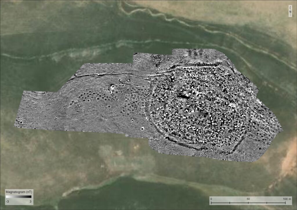
That changed when researchers returned with magnetometry and ground-penetrating radar. The instruments revealed a large oval feature running around the hilltop: a perimeter ditch nearly 400 meters long, enclosing an area of about 1.2 hectares.
The feature was not clearly visible from the ground or in satellite imagery. Only geophysical survey made its shape readable.
Targeted excavations later confirmed the ditch. In one trench, it measured about 7 meters wide and 85 centimeters deep. In another, it was about 4 meters wide and roughly 1 meter deep. On the inner side of the ditch, archaeologists also identified regularly spaced postholes, possibly linked to a light defensive structure such as a wooden palisade.
The result is not the plan of a permanent city or a major stone fortress. It looks more like a controlled, temporary occupation: a defensible hilltop, an enclosing ditch, possible timber defenses, and little evidence for substantial internal architecture.
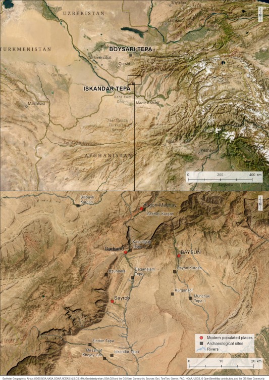
Map of the Bactro-Sogdian borderlands with the settlements of the Hellenistic and Transitional period indicated, by L. Stančo, T. Tencer. Credit: Stančo, Kysela, Tencer, Milo, & Shaydullaev, 2026
Water Storage on a Dry Frontier
Inside the enclosed area, the team found many large ceramic storage vessels, known locally as khums, sunk directly into the ground. These jars had already been noticed during earlier excavations, but the geophysical survey showed how widespread such buried features were across the site.
Several of the excavated vessels contained white calcareous deposits on their walls or bottoms. Attempts to recover plant remains from the jars did not produce useful evidence, which led the researchers to suggest that they may have stored liquid, probably water.
That interpretation fits the landscape. Iskandar Tepa has no known spring or well on the summit. A group stationed there would have needed to bring water from the valley, collect rainwater, or use channels. One linear feature detected along the northern slope was interpreted as a possible canal, and the study suggests it may have carried water toward the settlement from some distance.
For a military camp in a semi-arid environment, water would have been as important as the ditch. The buried jars point to planning rather than casual occupation.
Coins from the Greco-Bactrian Age
The site’s date comes from pottery and metal finds, especially coins recovered during surface survey. These include coins associated with Greco-Bactrian rulers such as Diodotus II, Euthydemus I and Demetrius I.
The main occupation is dated most likely to the 2nd century BCE, with possible continuation into the 1st century BCE. That places Iskandar Tepa in the Hellenistic world that followed Alexander’s campaigns, when Greco-Bactrian rulers controlled parts of Central Asia and military outposts helped secure routes, valleys and frontier zones.
This is where the Alexander connection matters. The camp was not necessarily used by Alexander’s own army. Its importance lies in showing how the Greek military and political landscape that emerged after his conquest may still have shaped Central Asia generations later.
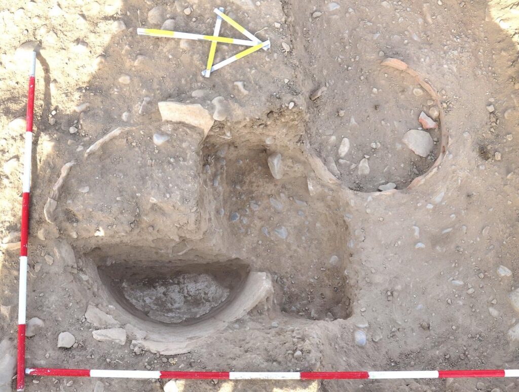
Iskandar Tepa, trench IT21-03/04. Khum vessels B (right) and C (left). Photo by J. Kysela.Credit: Stančo, Kysela, Tencer, Milo, & Shaydullaev, 2026
A Cemetery After the Camp
The hilltop did not lose its significance after the military phase ended. Around the edges of the site, geophysical survey detected nearly 90 oval pits, grouped mainly in eastern and western clusters. Researchers interpret them as burial pits.
Some of these graves appear to belong to a later period, around the 1st century BCE to 1st century CE, during the Transitional or Yuezhi period. In some places, burial activity seems to overlap with earlier settlement features, suggesting that the abandoned camp was later reused as a cemetery.
That reuse adds another layer to the site’s history. Iskandar Tepa was not a single frozen moment. It was a strategic hilltop that changed function over time, from a controlled Hellenistic occupation to a place of burial for later communities.
A Rare Glimpse of Hellenistic Military Life in Central Asia
The researchers compare Iskandar Tepa with Boysari Tepa in central Sogdiana, another elevated site with a comparable fortified area. They also note that Greek military camps known from written and archaeological models often used naturally defended positions, irregular or circular layouts, ditches, ramparts or palisades, and limited permanent architecture.
Iskandar Tepa matches many of those features. Its elevated position, oval ditch, possible palisade, lack of durable buildings, and signs of temporary or occasional use all support the military camp interpretation.
The find is important because such sites are difficult to recognize. Temporary camps do not leave the same visible ruins as cities, temples or fortresses. A shallow ditch can disappear beneath erosion. Wooden defenses vanish. Storage jars remain only as buried anomalies until instruments detect them.
At Iskandar Tepa, geophysics turned an apparently modest hilltop into evidence for a wider military landscape on the far eastern edge of Alexander’s world. More than 2,000 years later, the site offers a rare look at how soldiers may have occupied, supplied, and defended a frontier between Bactria and Sogdiana.
Stančo, L., Kysela, J., Tencer, T., Milo, P., & Shaydullaev, S. (2026). Geophysical and archaeological survey of the Hellenistic-period settlement Iskandar Tepa in the Bactro-Sogdian borderlands. Journal of Archaeological Science: Reports, 72, Article 105742. https://doi.org/10.1016/j.jasrep.2026.105742
Cover Image Credit: Stančo, Kysela, Tencer, Milo, & Shaydullaev, 2026
