Archaeologists in Peru’s Chicama Valley have discovered a 2-kilometer Chimú “Sacred Road” geoglyph, a temple platform, and more than 100 hectares of agricultural fields, revealing an integrated ritual and farming landscape dating to AD 1100–1470.
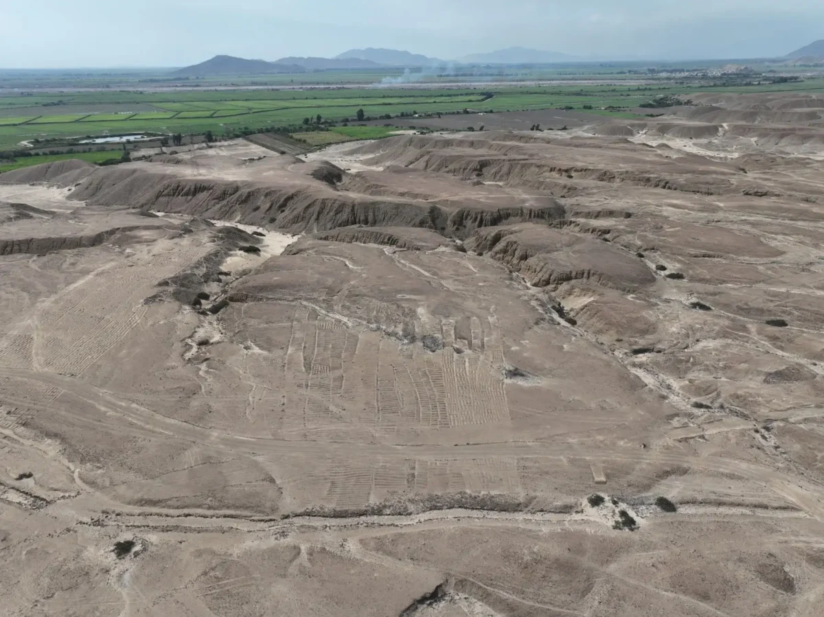
In the dry expanse of Peru’s northern coast, archaeologists have identified what may be one of the most revealing Chimú landscapes documented in recent years: a two-kilometer-long geoglyph, a monumental temple platform, and more than 100 hectares of agricultural fields forming a single, integrated complex in the Chicama Valley.
The discovery, announced by the Chicama Archaeological Program and reported by Peru’s state news agency Agencia Andina, reshapes understanding of how the Chimú state organized territory, production, and ritual life between roughly AD 1100 and 1470. Rather than isolated monuments, the evidence points to a carefully engineered cultural landscape in which farming, ceremony, and political authority operated as a unified system.
A Ritual Road Across the Desert
At the center of the discovery is a newly documented geoglyph interpreted as a camino ritual—a ceremonial road constructed from aligned stone accumulations. Stretching at least two kilometers in a remarkably straight line, the feature cuts across ancient ravines while maintaining a constant orientation in the landscape.
The geoglyph appears to connect the fortified settlement of Cerro Lescano with extensive cultivation zones and continues toward Cerro Tres Cruces. According to archaeologist Henry Tantaleán, co-director of the Chicama Archaeological Program, this is the clearest known example of a Chimú settlement physically linked to key landscape features through a formalized ritual corridor.
📣 Our WhatsApp channel is now LIVE! Stay up-to-date with the latest news and updates, just click here to follow us on WhatsApp and never miss a thing!!
Although Peru is globally known for the Nazca Lines, this find underscores that large-scale geoglyph traditions were not confined to southern Peru. Instead, Chimú communities on the north coast may have used monumental linear features to structure sacred movement and articulate relationships between settlements, mountains, and agricultural zones.
Tantaleán suggests that Cerro Lescano and Cerro Tres Cruces may have functioned as local apus—sacred mountains in Andean cosmology—indicating that the geoglyph was not merely a path, but a symbolic axis embedding agricultural production within a sacred geography.

A 100-Hectare Agricultural Complex
Equally significant is the scale of the surrounding farmland. Drone-based mapping and systematic survey have revealed at least 100 hectares of agricultural furrows in the Pampas de Lescano sector alone, substantially expanding previous estimates of Chimú agricultural capacity in the valley.
The fields display diverse configurations, including serpentine and comb-like patterns, and were supplied by secondary canals branching from the Gran Canal de la Cumbre—an important hydraulic artery in the region. Nearby research in Quebrada del Oso had previously identified around 60 hectares of fields, but the new documentation suggests the productive footprint of Chimú farming here was considerably larger.
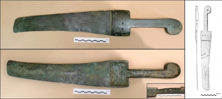
Preliminary excavations within the fields have yielded stone agricultural tools such as hoes, reinforcing evidence for intensive cultivation. Soil samples have been collected for phytolith and pollen analysis, which will help confirm what crops were grown. Earlier studies in the wider Chicama area indicate likely cultivation of maize, squash, and beans, staples that supported both subsistence and state-level redistribution.
This scale of coordinated farming points to substantial labor organization and administrative oversight—key hallmarks of the Chimú polity before its incorporation into the Inca Empire.
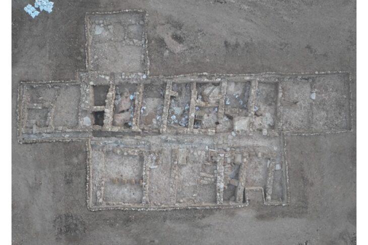
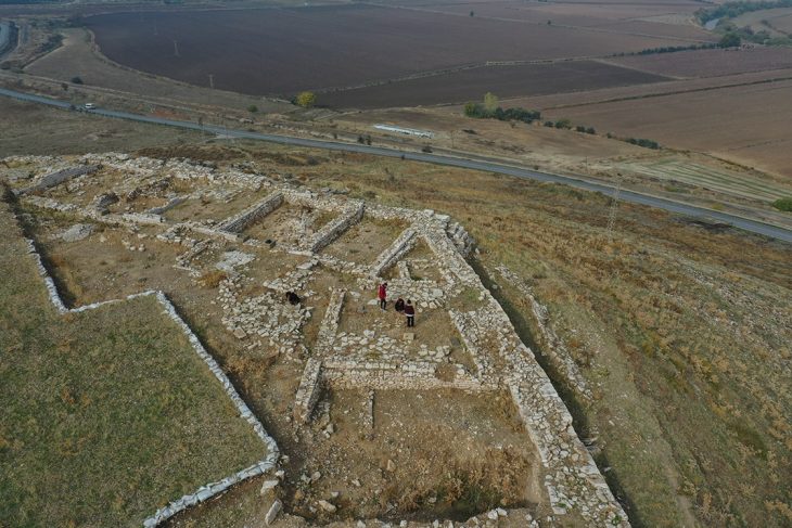
Temple Platform and Ceremonial Plaza
The agricultural landscape is anchored by a substantial ceremonial complex. Archaeologists documented a quadrangular stone platform measuring approximately 40 by 50 meters and rising two to three meters high. The structure is oriented north, a feature consistent with Chimú architectural conventions.
In front of the platform lies a large rectangular plaza, roughly 100 by 80 meters in size, capable of hosting sizable gatherings. Surface finds of classic Chimú ceramics at both the fortified settlement and the ceremonial platform indicate primary occupation between AD 1100 and 1470, with possible continuity into the Inca period.
Tantaleán argues that the spatial relationship between the fields, geoglyph, settlement, and temple demonstrates integrated territorial planning. Agricultural production was not organized solely through political authority or coercion. Instead, ritual performance and sacred movement appear to have been instrumental in mobilizing labor and reinforcing elite control.
In this interpretation, religion, economy, and politics were inseparable. The geoglyph functioned as a ritualized connector—binding sacred mountains, cultivated land, and ceremonial architecture into a single ideological framework.

Technology and Emergency Archaeology
Although the area had been noted by researchers in the 1970s and 1980s, including James Kus and Richard Keatinge, modern technologies such as drone-based digital mapping allowed the current team to document the sectorat unprecedented resolution.
International coverage has emphasized the urgency of this work. As reported by Ancient Origins, expanding private activity, high-tension power towers, service roads, and agricultural infrastructure are actively impacting the fields and geoglyph. Researchers describe their efforts as a form of emergency archaeology, racing to record features that may soon be irreversibly damaged.
Rethinking Chimú Statecraft
The Chicama discoveries contribute to a growing body of research highlighting the sophistication of Chimú territorial organization on Peru’s north coast. Known for their capital at Chan Chan and for advanced irrigation systems, the Chimú developed one of the largest pre-Columbian states in South America prior to Inca expansion.
What distinguishes the Chicama complex is the visible integration of monumental ritual infrastructure directly within an expansive agricultural matrix. The evidence suggests that state power was embedded physically and symbolically in the productive landscape itself.
By linking fortified settlements, sacred hills, irrigation-fed fields, and ceremonial architecture through a two-kilometer geoglyph, the Chimú appear to have inscribed political theology onto the land.
As laboratory analyses continue and further documentation proceeds, the Chicama Valley may prove central to understanding how pre-Hispanic Andean societies fused belief systems, hydraulic engineering, and agricultural intensification into a coherent political strategy—one written not only in adobe walls and ceramics, but across the desert floor itself.
Chicama Archaeological Program
Cover Image Credit: Chicama Archaeological Program