

Archaeologists working in shallow waters north of Rome have documented the remains of an Etruscan harbor just 130 meters from the ancient sanctuary of Punta della Vipera, raising the possibility that the two formed parts of the same coastal complex.
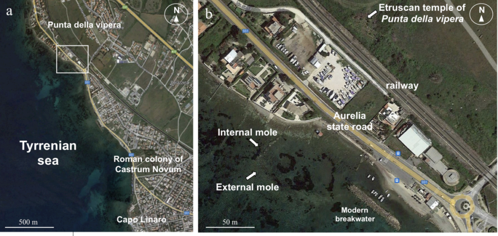
The stone-built harbor lies off Santa Marinella, about 90 meters from the modern shoreline, while the sanctuary stood immediately inland overlooking the Tyrrhenian Sea. Researchers argue that the proximity of the two sites was probably not accidental: the harbor may have provided direct access to a sacred place founded in the sixth century BCE and extensively rebuilt several generations later.
The interpretation appears in a new peer-reviewed study published in the Journal of Cultural Heritage. The research develops earlier work presented in a 2024 preprint, but adds a more cautious chronology for the submerged structure. Rather than dating the harbor to the foundation of the sanctuary itself, the new study places its construction most likely around the late fourth or early third century BCE — a period when the temple was also undergoing major changes. If confirmed, the researchers say it would be the earliest known harbor facility associated with an Etruscan temple.
An L-shaped harbor beneath the sea
The remains were identified during underwater surveys along the coast between Punta della Vipera and Capo Linaro, an area better known for its Roman maritime archaeology. The team was investigating the coastal landscape around Castrum Novum when a much earlier arrangement of large stone blocks emerged from the seabed about 800 meters north of the Roman settlement.
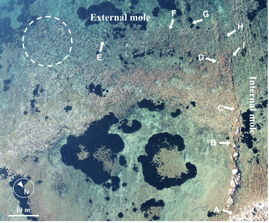
What survives is not simply a scattered collection of stones. Large calcarenite blocks were laid in organized rows, with smaller stones and rubble filling the space between them. In the best-preserved section, two parallel lines of blocks form the sides of what researchers identify as a mole or breakwater. The structure eventually turns toward the coast, producing an L-shaped harbor enclosing roughly 3,000 square meters.
The outer breakwater extended for more than 60 meters and exceeded five meters in width. Much of it has disappeared, but its lowest courses remain on the seabed. The 2024 survey suggested that the protected basin was large enough to allow substantial ancient vessels to maneuver inside.
One feature makes the construction particularly interesting. A narrow channel, about 60 centimeters wide, passes through the stonework and connects the sheltered basin with the open sea. The researchers interpret it as a way of maintaining water circulation and reducing the accumulation of sediment inside the harbor — evidence that the installation was deliberately engineered rather than simply adapted from a natural anchorage.
Part of the harbor appears to have incorporated an existing rocky formation, but the outer mole was artificial. Many of its shaped blocks were probably removed in antiquity and reused elsewhere, leaving mainly the basal stones that were hardest to extract.
The temple was turned toward the sea
The harbor becomes far more significant because of what stood immediately behind it.
The Punta della Vipera sanctuary was founded around 540–530 BCE in the territory of the Etruscan city of Caere. Inscriptions and votive material identify the deity worshipped there as Menerva, the Etruscan counterpart of Roman Minerva. Archaeologists have also recovered anatomical votive offerings and fragments of an inscribed lead object from the sacred area.
The sanctuary was not static. It underwent rebuilding during the fourth and third centuries BCE and remained in use long after its original foundation. That later phase overlaps much more closely with the chronology now proposed for the harbor.
The relationship becomes even more intriguing when the orientation of the sanctuary is considered.
According to the researchers’ reconstruction, its entrance did not face the principal inland route toward Castellina, the nearby Etruscan settlement. It faced south, toward the sea and the harbor. The 2024 study proposed that people arriving by ship could have left the waterfront and climbed approximately eight to nine meters to reach the sanctuary, perhaps along a route that functioned as a sacred approach.
The authors went further, suggesting that sailors using the harbor may have visited the sanctuary and deposited offerings there. That remains an interpretation rather than something demonstrated archaeologically, since modern railway construction, the Via Aurelia and later development have disrupted the ground between the waterfront and the temple. But the alignment gives the harbor-temple connection a physical dimension that goes beyond their proximity on a map.
Why the harbor is not being dated to the sixth century BCE
The harbor itself has not yet produced material capable of providing a direct construction date.
No surviving wooden elements or other organic remains suitable for radiocarbon analysis have been excavated, while ceramics from the harbor basin are scarce. Researchers did find fragments of red clay building material similar to material recovered from the sanctuary, but that alone cannot establish when the moles were built.
Instead, the 2026 study combines archaeological evidence with ancient sea-level reconstruction. Parts interpreted as former walking surfaces are now approximately 0.5 to 0.6 meters underwater. The researchers estimate that sea level when the harbor was functioning would have been at least 1.2 to 1.4 meters lower than today, helping place construction around the end of the fourth or beginning of the third century BCE.
That chronology is important. It means the harbor should not simply be described as a sixth-century BCE structure because the neighboring temple is that old. The evidence instead points toward a harbor added or substantially developed during a later chapter in the sanctuary’s long history.
Physical traces of Etruscan maritime infrastructure are unusually scarce despite ancient accounts describing Etruscan power at sea. Coastal erosion, rising sea levels, later Roman construction and the reuse of valuable building stone have erased much of that landscape. This makes the submerged remains at Punta della Vipera particularly unusual.
Excavation inside the basin could eventually settle some of the questions that the underwater survey cannot. Securely dated ceramics, construction deposits or organic material could establish when the harbor was built and how long it remained in use. More importantly, they could test the possibility raised by the geography of the site: that ships approaching this stretch of the Etruscan coast were arriving not merely at a harbor, but at a harbor built to serve a sanctuary overlooking the sea.
Source
Giorgi, M., Napoli, S., Rinaldi, T., Enei, F., Giorgi, S., & Chiocci, F. L. (2026). Newly discovered ship-landing site serving the Etruscan coastal temple in Punta Della Vipera, Santa Marinella, Rome (Italy). Journal of Cultural Heritage, 80, 189–196. https://doi.org/10.1016/j.culher.2026.05.013
Giorgi, M., & Giorgi, S. (2024). Newly discovered ship-landing site serving the Etruscan coastal temple in Punta Della Vipera, Santa Marinella, Rome (Italy) [Preprint]. viXra. https://vixra.org/abs/2408.0111
