
Researchers say the 3,000-square-meter shell island near Culasawani was likely formed by generations of people processing shellfish and discarding the remains more than 1,200 years ago.
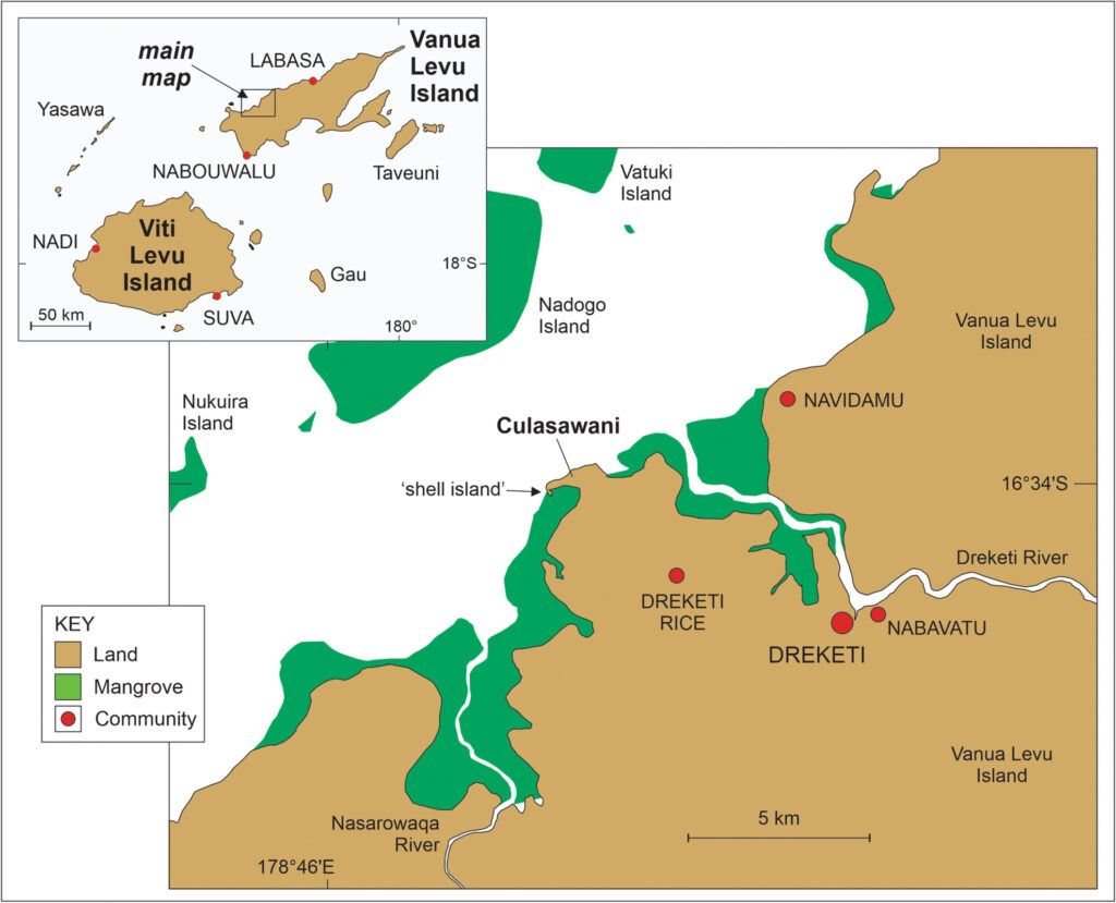
A Fiji shell island surrounded by mangroves may not be a natural landform at all. New geoarchaeological research suggests that a low island off Culasawani, on the northern coast of Vanua Levu, was gradually built from ancient seafood waste, pottery fragments, and the repeated labor of people who processed shellfish there more than a thousand years ago.
The site covers about 3,000 square meters and rises only modestly above the tide. At first glance, it could pass for a coastal feature shaped by waves, sediment, and mangrove growth. But its internal structure tells a stranger story. Researchers found that the island is made up largely of shell material, with shell-rich deposits accounting for roughly 70 to 90 percent of its makeup in places.
Radiocarbon dating places the main formation of the deposit around 760 CE, with dated samples ranging from about 420 to 1040 CE. If the interpretation is correct, the Culasawani site may be the first described “midden island” in the tropical Pacific east of the Bismarck Archipelago in Papua New Guinea.
Crabs first exposed the hidden island
The first clues did not come from a deep trench or a laboratory result. They came from crabs.
📣 Our WhatsApp channel is now LIVE! Stay up-to-date with the latest news and updates, just click here to follow us on WhatsApp and never miss a thing!!
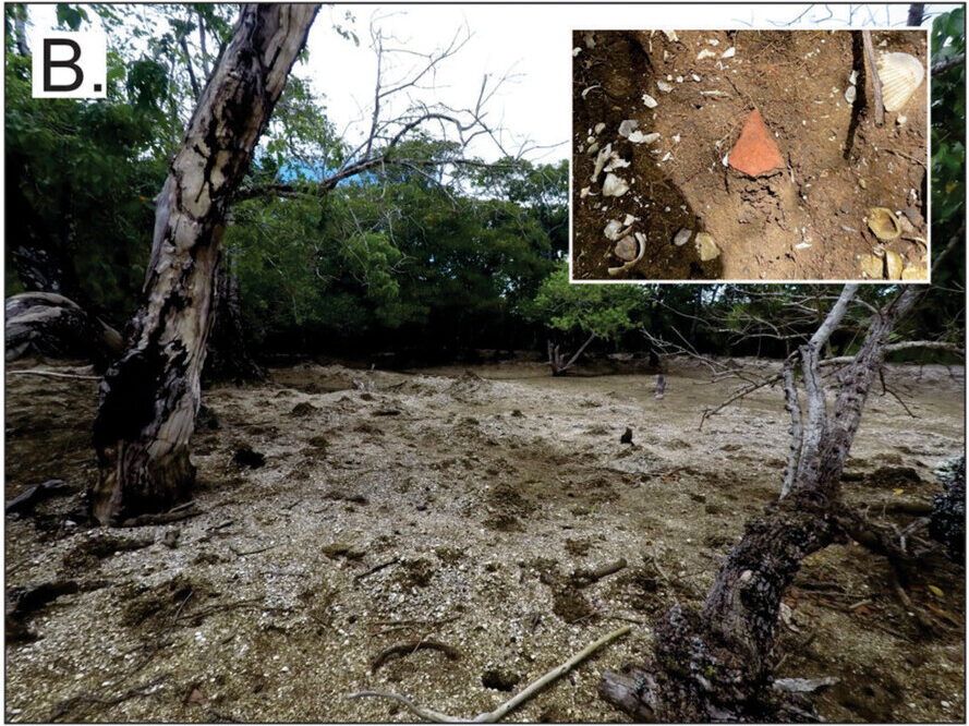
When researchers first noticed the site in 2017, burrowing mud crabs had already brought pieces of shell and pottery to the surface from depths of about 30 to 50 centimeters. That detail mattered. The shells were not simply scattered across the top of the ground. They formed the body of the island itself.
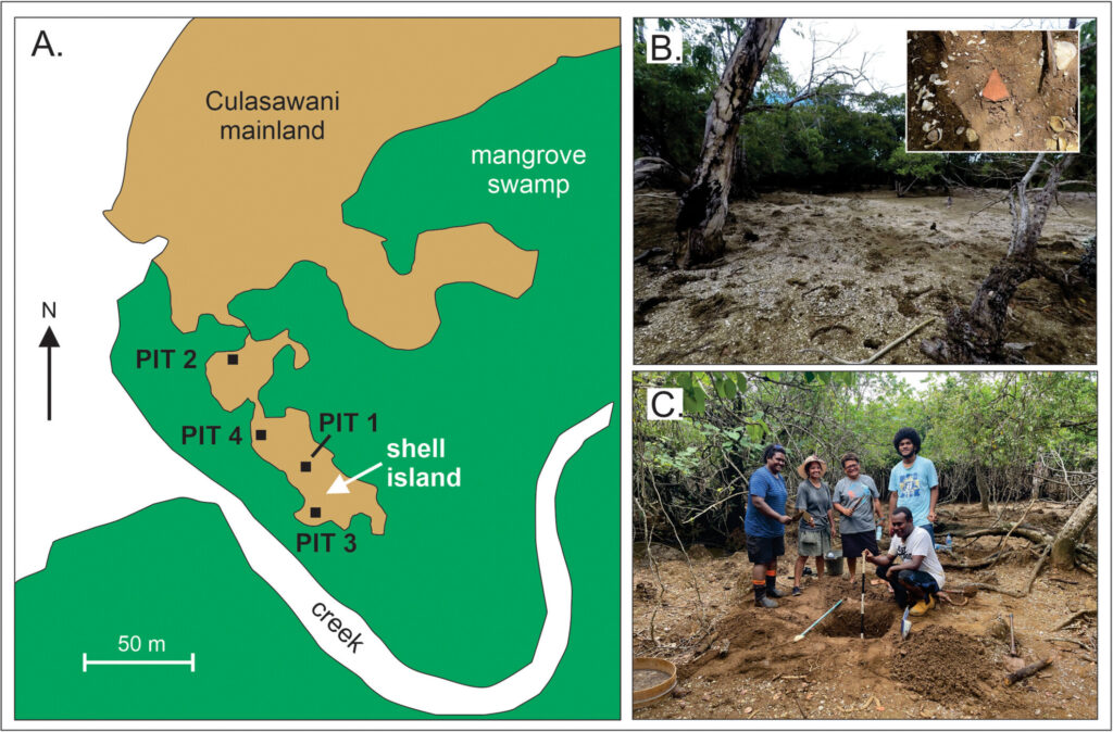
Two fieldwork phases followed in 2024. Researchers mapped the site, drilled 20 hand-auger cores, and excavated several 1-by-1-meter test pits. The results showed a relatively uniform shell-dense deposit, usually 20 to 40 centimeters thick, sitting above a harder coastal platform.
The island is now surrounded by mangrove forest and remains above mean high tide. Its surface reaches up to about 60 centimeters above mean high tide in some places, although most emergent areas rise more modestly.
A seafood-processing place, not a village
The strongest evidence for human activity lies in the shells themselves. The remains are overwhelmingly from edible shellfish, especially Anadara species, along with other edible bivalves and gastropods. A natural wave or tsunami deposit would be expected to contain a more chaotic mix of marine debris, including stones, non-edible organisms, and varied seafloor material.
Instead, the Culasawani deposit looks selective. It is dominated by species people could collect, open, process, and eat.
Small fragments of plain pottery were also found at the site, both on the surface and within the deposit. The pottery appears consistent with the later pre-modern Fijian earthenware tradition. Its presence suggests people were using vessels at or near the shell island while the deposit was forming.
Yet the site lacks some things normally expected in a permanent settlement. Researchers did not find clear evidence of animal bones, fish remains, or stone tools. That absence may be significant. Rather than a village, the island may have been a specialized open-air processing station where shellfish were collected and prepared before the meat was carried elsewhere.
One possible scenario is simple but powerful: people gathered shellfish in nearby shallow waters, removed the edible flesh, discarded the shells in the same place, and transported the food in pots to a nearby settlement on the Culasawani mainland.
Over generations, that repeated activity may have created land.
The tsunami question remains
The researchers considered another explanation. Could a large wave, perhaps a tsunami, have swept shell material from the seabed and dumped it into one place?
That possibility is not unreasonable. Northern Vanua Levu lies in a region affected by seismic activity, and the wider Fiji area has tsunami risk. The shell layer is also relatively thin and lacks clear stratification, traits that could suggest disturbance.
But several observations make a tsunami origin less convincing. The shell-rich material appears confined to the island rather than thinning inland in a pattern typical of wave deposition. The dated shells also cluster closely in time, and the material is composed of edible species rather than a random marine mixture.
For now, the authors favor the midden interpretation. In archaeological terms, a midden is a deposit formed from discarded food remains and other traces of daily activity. A midden island is more unusual: a landform shaped by human discard over time, sometimes helped by changing sea levels and coastal processes.
A rare look at early Fijian coastal life
The Culasawani shell island matters because Vanua Levu, Fiji’s second-largest island, remains less archaeologically studied than many other parts of the archipelago. The discovery gives researchers a new way to think about how early Fijian communities used coastal ecosystems.
The site sits near a creek mouth, shallow marine habitats, and an upland area that could have supplied timber and other resources. Around 1,200 years ago, the landscape likely looked different. The surrounding mangrove forest may have been less extensive than it is today, making the area more open and accessible to people working along the shore.
The researchers also raise the possibility that people may once have lived on platforms above the tidal flat, similar to stilt-platform settlements known elsewhere in the southwest Pacific. As shells accumulated and relative sea level changed, an area once washed by tides may gradually have become dry ground.
That idea is difficult to prove without further excavation. No structural remains have yet been identified at the Culasawani shell island. Future work will focus on nearby mainland settlement traces, offshore shell deposits, and local oral traditions that might preserve memories of major wave events.
For now, the island remains both archaeological evidence and a question. It may be a rare Pacific example of a landscape built unintentionally, meal by meal, shell by shell. What looks today like a small patch of land in the mangroves may actually be the durable footprint of a community that turned the shoreline into a working place, and, over centuries, into an island.
Nunn, P. D., F. R.Thomas, M.Fong-Lomavatu, et al. 2026. “Shell-Dense Island Off Culasawani, Vanua Levu Island, Fiji: Midden or Muddle?” Geoarchaeology0: e70052. https://doi.org/10.1002/gea.70052.
Cover Image Credit: General view of the surface of the Culasawani shell island; inset shows a 2-cm long potsherd within the shell midden (side of crab mound). Nunn, P. D., et.al., 2026