For centuries, the ancient city of Buto in Egypt’s Nile Delta has kept its deepest secrets buried beneath layers of mud, water, and time. Now, a combination of space-based radar and underground scanning has revealed what archaeologists could not see before: a large, 2,600-year-old structure hidden beneath one of Egypt’s most complex archaeological landscapes.
The discovery, published in Acta Geophysica, marks a turning point—not just for Buto, but for how archaeologists explore layered ancient sites where traditional excavation struggles to reach.
A City Buried in Layers
Buto, known today as Tell el-Fara’in, is no ordinary archaeological site. It is a multi-layered settlement whose history stretches back to the Predynastic period, over 5,000 years ago. Across millennia, new structures were built over older ones, creating a dense, stratified landscape where entire phases of history lie hidden beneath later occupations.
Excavating such a site is far from straightforward. Much of the Nile Delta sits close to the water table, meaning that deeper layers are often waterlogged and unstable. Add to this the sheer volume of accumulated sediment and overlapping architecture, and Buto becomes less a site—and more a labyrinth.
For decades, these conditions have limited what archaeologists could uncover.
📣 Our WhatsApp channel is now LIVE! Stay up-to-date with the latest news and updates, just click here to follow us on WhatsApp and never miss a thing!!
So instead of digging blindly, researchers decided to change perspective.
Looking from Space Before Digging the Ground
The research team turned first to Sentinel-1 satellite radar (SAR), a technology capable of detecting subtle variations beneath the surface—even in challenging environments like the Nile Delta.
Unlike optical imagery, radar can penetrate soil and vegetation, identifying anomalies that may correspond to buried structures. In environments where surface visibility is misleading, this creates a kind of “map of the invisible.”
According to the study, SAR data has entered a “golden age” in archaeology due to its ability to operate in all weather conditions and detect subsurface features at large scales.
But detecting anomalies is only the first step.
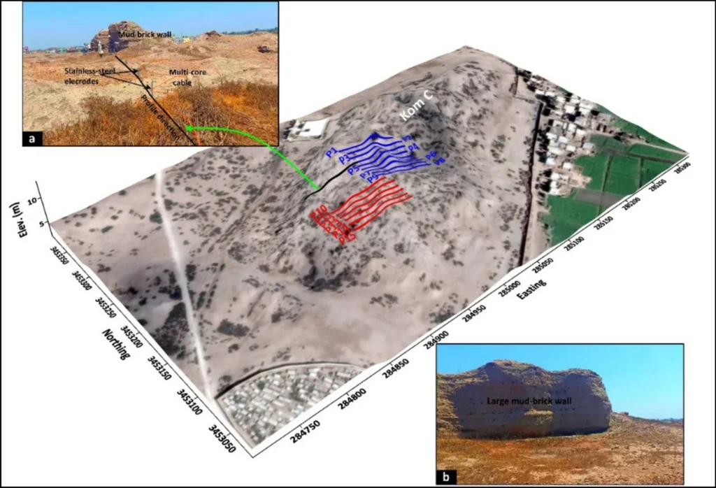
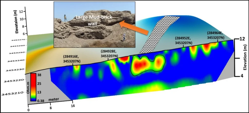
To understand what lay beneath, the team combined satellite data with electrical resistivity tomography (ERT)—a ground-based technique that measures how different materials respond to electrical currents. Clay, sand, and mudbrick structures all produce distinct signals, allowing researchers to reconstruct a three-dimensional model of the subsurface.
This combined approach allowed archaeologists to analyze the site in depth—without disturbing it.
Reading the Subsurface Like a Historical Archive
The results revealed a complex story encoded in layers.
Near the surface, within the first few meters, the data showed a chaotic mix of materials—ceramics, debris, and remains from the Ptolemaic and Roman periods. This was expected in a site occupied continuously for centuries.
But deeper layers told a different story.
At depths between roughly 3 and 5 meters, the models began to show clear, organized anomalies—patterns that suggested architectural structures rather than random deposits.
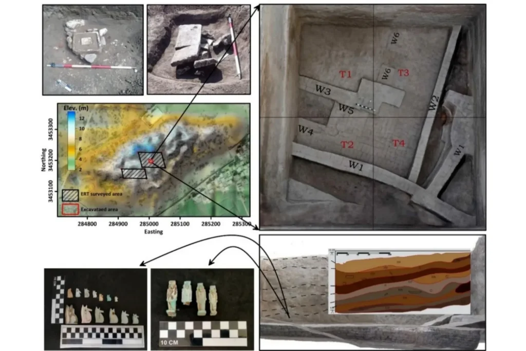
These anomalies were not subtle. The data indicated a mudbrick structure approximately 25 by 20 meters in size, constructed on an artificially prepared foundation—evidence of deliberate planning and engineering.
At this stage, however, interpretation remained cautious. In archaeology, shapes beneath the surface can be deceptive.
To confirm their findings, the team conducted a targeted excavation—a small, precisely chosen 10-by-10-meter area guided directly by the geophysical data.
What they found changed everything.
A Hidden Structure from Egypt’s Late Period
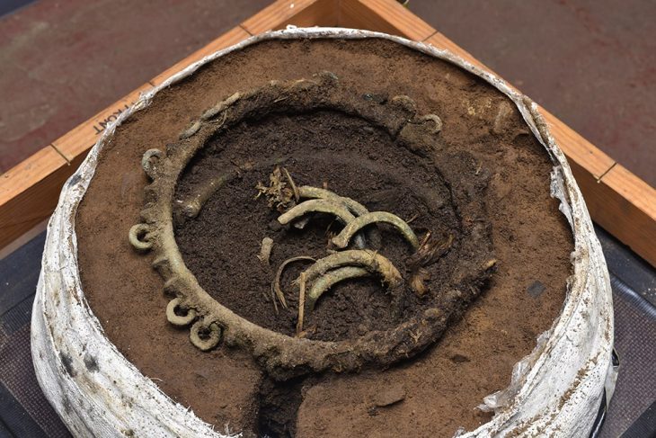
Beneath the surface, archaeologists uncovered mudbrick walls and a remarkable collection of objects that confirmed the nature of the buried structure.
The evidence pointed to a building dating to the Saite period (26th Dynasty), around 2,600 years ago—a time when Buto was an important religious center in Lower Egypt.
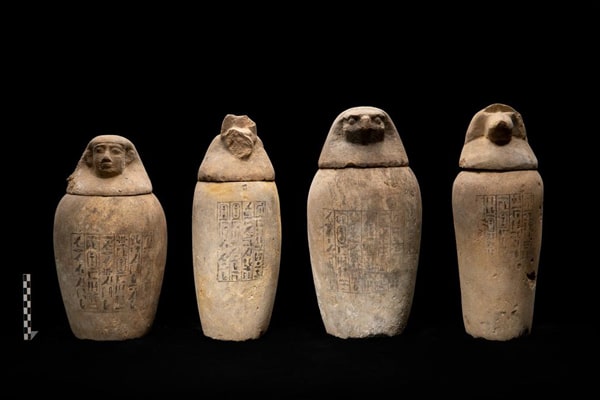
Among the discoveries were numerous religious artifacts: amulets depicting Egyptian deities such as Isis, Horus, Taweret, and Bes, as well as representations of Wadjet—the cobra goddess closely associated with Buto itself.
Some finds were particularly striking. A hybrid amulet combining features of a baboon, falcon, and dwarf deity, along with a scarab bearing the name of Pharaoh Thutmose III, hinted at deep symbolic and ritual significance.
Together, these objects strongly suggest that the structure served a religious or ceremonial function—possibly a secondary temple, a priestly residence, or a funerary complex.
While its exact purpose remains under investigation, the concentration of ritual items leaves little doubt: this was not an ordinary building.
Rewriting the Archaeological Map of Buto
Beyond the structure itself, the discovery is reshaping how archaeologists understand Buto.
The data indicates that the area was artificially leveled before construction, using layers of sand to stabilize the ground. This detail points to a level of urban planning and environmental adaptation that had not been fully recognized before.
It also confirms that significant parts of Buto’s history remain buried beneath later layers—some possibly still untouched.
Indeed, the study suggests that additional structures, including another potential temple, may lie hidden beneath thick clay deposits.
A New Era of “Excavation Without Excavation”
Perhaps the most important outcome of this research is methodological.
Traditionally, archaeology has relied on excavation—digging through layers to uncover the past. But in environments like the Nile Delta, excavation is expensive, time-consuming, and often destructive.
This study demonstrates that a different approach is possible.
By combining satellite remote sensing with geophysical techniques, archaeologists can now map entire buried landscapes before breaking ground. This allows for more precise, targeted excavations—reducing both cost and environmental impact.
It also helps preserve sites for future generations, an increasingly urgent priority as climate change and urban expansion threaten archaeological heritage worldwide.
The Past, Still Waiting Below
Buto has long been known as one of Egypt’s most important ancient cities, a counterpart to Upper Egypt’s Hierakonpolis in religious and cultural significance.
Yet even after more than a century of research, much of its story remains hidden.
Now, thanks to technology that can see beneath the surface, archaeologists are beginning to uncover those lost chapters—not by digging blindly, but by reading the earth itself.
Something significant lay buried beneath Buto for millennia.
It simply required a new way of looking to be found.
Abouarab, M.A.R., Elfadaly, A., Elbehery, W. et al. Multi-scale detection of buried archaeological elements across different occupation phases: an integrated approach using radar satellite imagery and electric resistivity tomography at Buto, northwestern Nile Delta of Egypt. Acta Geophys. 74, 112 (2026). https://doi.org/10.1007/s11600-026-01809-4
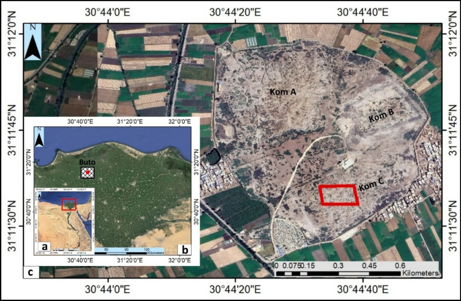
Cover Image Credit: Location map of Buto archaeological settlement a Google Earth image for Egypt; b the location of Buto in the northwest Nile delta; c close-up view of Buto site showing three separate mounds (Koms) and the investigated area bounded by red rectangle within Kom C. Credit: Abouarab, M.A.R., 2026, Acta Geophys