

For generations, the story of Nimrud has been told through its palaces, temples, monumental reliefs and Assyrian kings. But beyond the famous acropolis lies something much larger: a 340-hectare Lower Town containing streets, residential neighbourhoods, public buildings, workshops and open spaces that archaeologists have barely explored for almost 180 years.
A new archaeological project led by researchers from the University of Udine is now beginning to bring that hidden city into view. By combining historical aerial photographs, surface survey, drone mapping and magnetometry, the Nimrud Lower Town Archaeological Project, or NiLTAP, is reconstructing parts of the urban landscape that developed around one of the most important capitals of the Assyrian Empire.
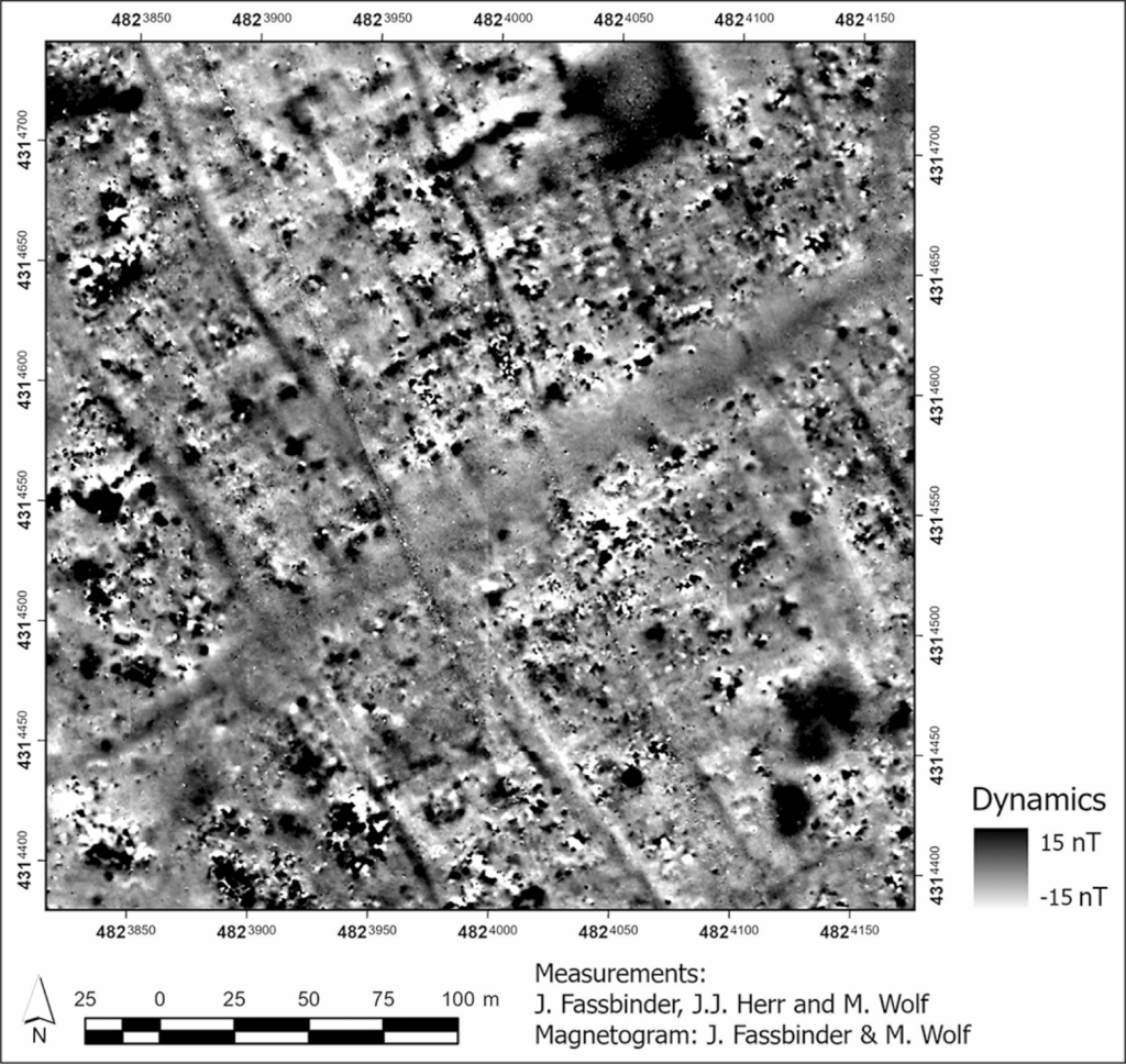
The preliminary results suggest that beneath the agricultural fields surrounding Nimrud’s monumental core survives a highly organised city. Magnetometer surveys carried out in selected areas have identified structured street systems, domestic neighbourhoods and larger architectural complexes, offering one of the clearest indications yet of how the population beyond the royal precinct may have lived.
Archaeology at Nimrud Has Long Been Dominated by Its Palaces
Since Austen Henry Layard began excavating Nimrud in 1845, archaeological attention has concentrated overwhelmingly on the acropolis and its palaces, temples, artworks and inscriptions. Apart from limited investigations at locations including Fort Shalmaneser and several palace complexes, the enormous Lower Town remained largely outside the main trajectory of research. An attempt to examine its urban layout between 1987 and 1989 was interrupted by the First Iraq War.
That imbalance has shaped modern understanding of Assyrian capitals. Archaeologists know considerably more about kings, royal architecture, and court culture than they do about the wider populations who occupied these cities. NiLTAP was established specifically to address that gap by examining Nimrud as an urban system rather than primarily as a collection of royal monuments.
The Lower Town offers an unusual opportunity to do so. It is surrounded by nearly eight kilometres of fortification walls with monumental gates and towers, yet much of the interior has remained relatively undisturbed. Following the fall of the Assyrian Empire in 612 BC, the area was not intensively reoccupied, while modern agricultural activity generally involves shallow ploughing of around 20 centimetres.
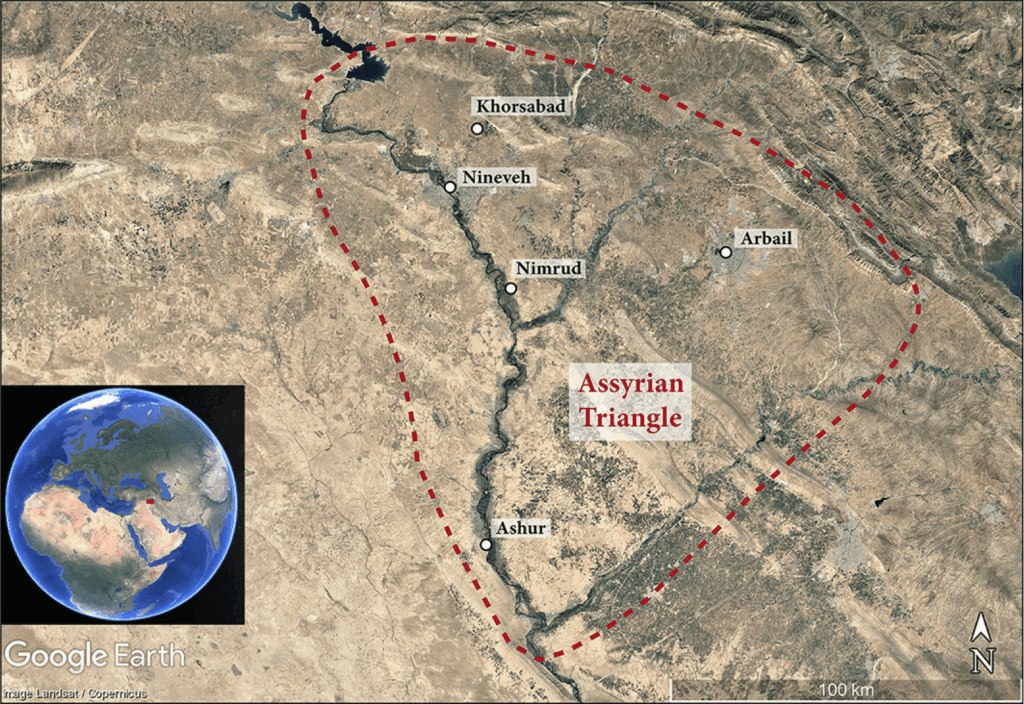
Cold War-Era Images Helped Reveal the Forgotten City
Before archaeologists began mapping the Lower Town on the ground, some of its structure could already be detected from above. Researchers examined declassified U2, CORONA and HEXAGON imagery dating from 1967 to 1974, which showed traces of fortifications, city gates and streets as well as areas that appeared to contain dense settlement, more dispersed occupation and open spaces.
During the 2025 field season, these observations were tested using modern surveying methods. A DGPS and drone programme produced a new topographic map, orthophoto and Digital Terrain Model, while archaeologists systematically walked the Lower Town in a 40 × 40-metre grid to record surface material and its spatial distribution.
The results reveal a landscape that changed repeatedly over thousands of years. Evidence indicates occupation from the third millennium BC into the Islamic period, with particularly intensive activity during the Middle Assyrian, Neo-Assyrian and post-Assyrian phases.
Streets and Neighbourhoods Beneath the Fields
Magnetometry has provided perhaps the most immediate glimpse of the buried city. In surveyed sectors, magnetic anomalies form patterns consistent with organised streets, residential quarters and larger building complexes, allowing archaeologists to connect surface artefacts with architecture that remains underground.
This shift in scale is significant. Instead of reconstructing Nimrud primarily from throne rooms and monumental inscriptions, researchers can begin asking how neighbourhoods were organised, where people lived, how movement through the city was structured and how different zones may have functioned within the imperial capital.
The survey also recovered epigraphic material, mostly fragments of inscribed baked bricks. Among the finds were fragments belonging to five different prisms associated with the Assyrian kings Sennacherib and Ashurbanipal, rulers who lived after the imperial court had moved away from Nimrud.
Nimrud’s Main Water Source May Need to Be Reconsidered
The project is also forcing researchers to reconsider one of the basic questions about the ancient city: where its water came from.
New topographic observations around the Patti-Ḫegalli canal, constructed under Ashurnasirpal II, indicate that the traditional reconstruction of Nimrud’s hydraulic system may require substantial revision. According to the researchers, a canal system farther north may actually have served as the city’s principal water source, rather than the Patti-Ḫegalli itself.
That possibility could alter interpretations of how water was brought into the capital and how different parts of the urban landscape were organised around access to it.
A Capital Seen Beyond Its Kings
Nimrud served as an Assyrian imperial seat from approximately 879 to 707 BC, giving archaeologists an unusually long window into the development of an imperial city. The preservation of its Lower Town may allow researchers to follow changes in its urban organisation across nearly two centuries of political history.
The work is still at an early stage. Future seasons are expected to extend geophysical surveys and add geoarchaeological investigations, targeted soundings and larger excavations.
What is already changing, however, is the scale at which Nimrud can be understood. The palaces that made the Assyrian capital famous occupy only part of the archaeological landscape. Beyond them lies a city hundreds of hectares in extent, and after almost two centuries of archaeological attention focused elsewhere, its streets and neighbourhoods are finally beginning to emerge.
Morandi Bonacossi, D., & Simi, F. (2026). New approaches to Assyrian capitals: the Nimrud Lower Town Archaeological Project. Antiquity, 1–8. doi:10.15184/aqy.2026.10423
