
Loch Bhorgastail crannog, a prehistoric human-made island in the Outer Hebrides, has revealed a hidden timber platform more than 5,000 years old, offering new evidence that some of Scotland’s artificial islands began life far earlier than archaeologists once believed.
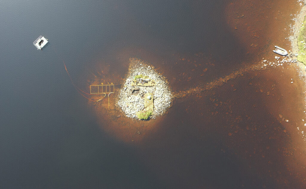
The site, located in a loch on the Isle of Lewis, appears today as a small stone-built island rising above the water. But new excavation and digital recording by archaeologists from the University of Southampton, working with the University of Reading, show that the visible stone cap rests above a much older structure of timber, brushwood and layered organic material.
The discovery places Loch Bhorgastail among a growing group of Neolithic crannogs in the Outer Hebrides. Once thought to belong mainly to the Iron Age, medieval and post-medieval periods, crannogs are now forcing archaeologists to rethink how early farming communities in northwest Europe used water, islands and monumental construction.
A Stone Island with a Timber Heart
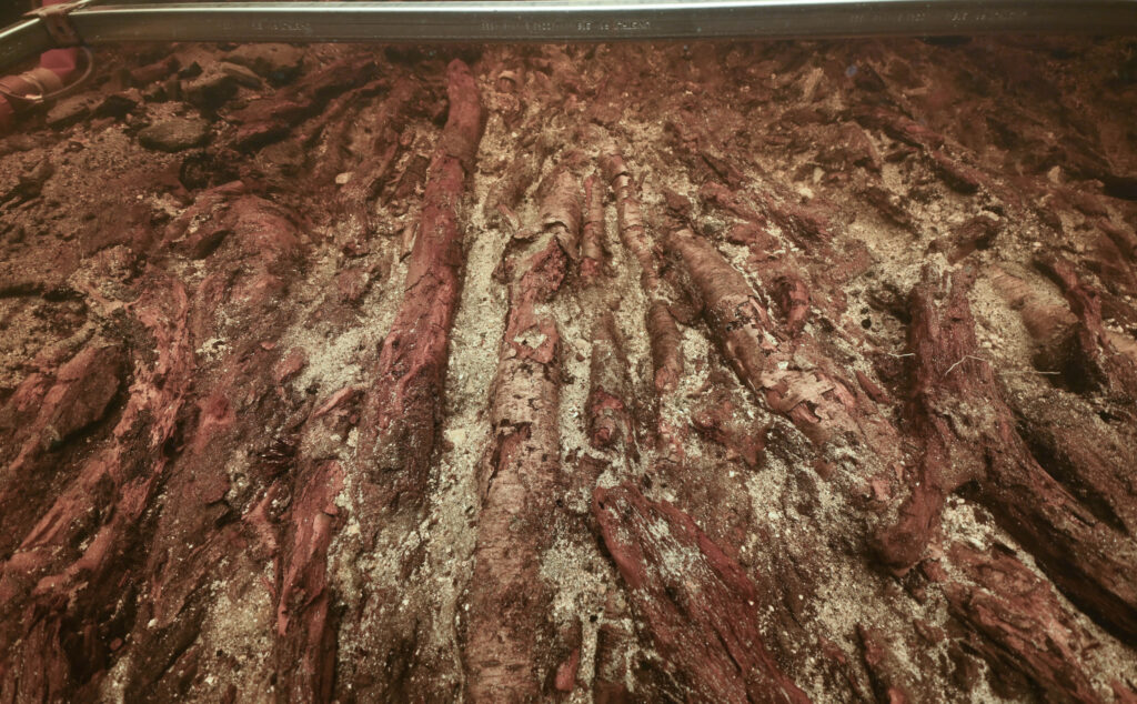
The new research shows that the earliest phase of the Loch Bhorgastail crannog was not simply a pile of stone placed in shallow water. Beneath the later stone surface, archaeologists identified a coherent wooden platform, around 23 metres across, built with timber and brushwood.
Radiocarbon evidence places the beginning of the site in the Neolithic, probably between about 3500 and 3300 BC. That makes the original structure older than Stonehenge’s most famous stone circle and places it in a period when communities across Britain and Ireland were building tombs, ceremonial landscapes and large communal monuments.
📣 Our WhatsApp channel is now LIVE! Stay up-to-date with the latest news and updates, just click here to follow us on WhatsApp and never miss a thing!!
The island was not static. Over centuries, it changed. After its Neolithic construction, a later phase of brushwood and stone was added during the Middle Bronze Age. Further activity followed in the Iron Age, suggesting that people returned to the same small island again and again, reshaping it according to different needs, beliefs or traditions.
A submerged stone causeway also links the crannog to the shore. Now hidden underwater, it shows that access to the island was carefully planned. The crannog was separated from daily life on land, but not unreachable.
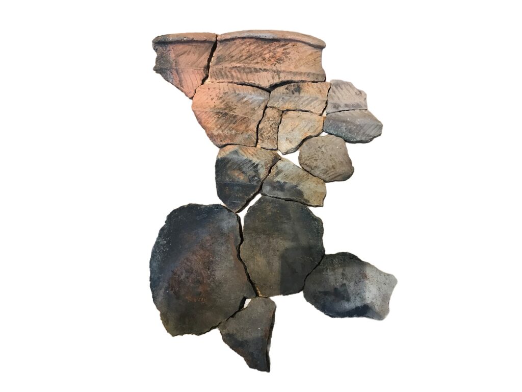
Hundreds of Neolithic Pottery Fragments in the Water
One of the most striking clues comes not from the island itself, but from the water around it.
Over years of survey and excavation, archaeologists have recovered hundreds of pieces of Neolithic pottery from the loch bed. These include fragments of bowls and jars, some found in unusually good condition. Earlier research on Neolithic crannogs in the Outer Hebrides showed that many vessels from similar sites had been used before entering the water, with soot or food residues preserved on some examples.
That pattern is important. It suggests that pottery was not simply lost by accident. At Loch Bhorgastail and related sites, vessels may have been deliberately placed or thrown into the water around the island after use. Such acts point to communal gatherings, feasting, cooking or ritualized deposition.
The crannog therefore may not have been an ordinary domestic platform. Its construction required planning, labour and access to resources. Its use left behind pottery, worked stone and food-related traces. Together, these finds suggest a place where social life, food preparation and symbolic activity may have overlapped.
A New Way to See the Water’s Edge
The new study also matters because of how the site was recorded.
Shallow water is one of archaeology’s most frustrating zones. Land-based survey methods often stop at the shoreline, while marine equipment usually works best in deeper water. The result is what researchers call the “white ribbon,” a narrow but archaeologically rich strip where evidence can be difficult to document.
At Loch Bhorgastail, the team developed a portable stereophotogrammetry method to solve that problem. Photogrammetry creates 3D models by combining many overlapping images. In this case, researchers used two waterproof cameras fixed at a set distance apart on a frame, allowing them to capture overlapping underwater images with greater precision.
A diver moved the camera rig through the shallow water, while positioning was controlled to centimetre-level accuracy. The underwater data were then combined with drone imagery and terrestrial survey data, allowing the island and its submerged elements to be recorded as one continuous structure.
This was crucial. The crannog does not stop at the waterline. Its stone, timber and brushwood layers cross the boundary between land and loch. By recording the entire site together, archaeologists could better understand how the island was built and how its visible and submerged parts related to one another.
The method is described in the newly published paper “At the Water’s Edge: Photogrammetry in Extreme Shallow-Water Environments,” published by Cambridge University Press in Advances in Archaeological Practice. The authors argue that the approach offers a repeatable, relatively low-cost way to document other archaeological sites in shallow water.
Rethinking Neolithic Scotland
The Loch Bhorgastail crannog belongs to a wider research story that began to change dramatically in 2012, when Lewis resident and former Royal Navy diver Chris Murray found remarkably preserved Neolithic pottery on the loch bed near artificial islets. Subsequent work by Murray, Mark Elliott of Museum nan Eilean, and academic teams helped show that several Outer Hebridean crannogs had Neolithic origins.
That overturned a long-standing assumption. Crannogs had been widely associated with later prehistoric and historic periods. The idea that people were building artificial islands in Scottish lochs more than 5,000 years ago pushed the history of this site type back by around two and a half millennia.
For archaeologists, the implications are significant. Neolithic communities in the Outer Hebrides were not only building tombs and houses. They were also creating islands. These places demanded heavy materials, technical skill and coordinated effort. They also occupied a powerful position in the landscape, neither fully land nor fully water.
Loch Bhorgastail now offers one of the clearest views yet of that world. Beneath a quiet stone island lies a timber platform from the deep Neolithic, preserved in waterlogged conditions and surrounded by the broken remains of ancient pottery. What once looked like a later stone crannog has become something more revealing: a rare survival of early island-building, communal activity and long-term memory in prehistoric Scotland.
Blankshein S, Pedrotti F, Sturt F, Garrow D. At the Water’s Edge: Photogrammetry in Extreme Shallow-Water Environments. Advances in Archaeological Practice. Published online 2026:1-16. doi:10.1017/aap.2025.10145