
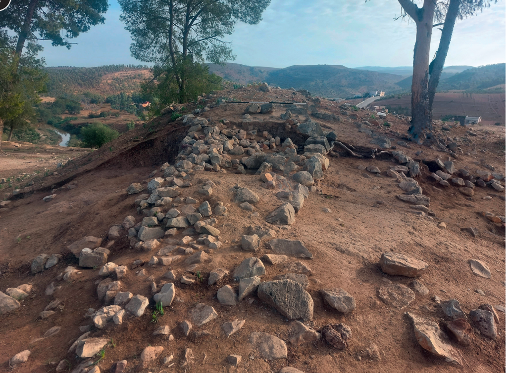
Archaeologists working at Oued Beht in northwestern Morocco have uncovered a defensive system built as much as 4,000 years ago, potentially making it the oldest known fortification in North Africa outside the Nile Valley.
The discovery is reshaping the story of a site already known for something extraordinary. Oued Beht previously revealed a vast farming community that flourished between about 3400 and 2900 BC. Now excavations show that people returned to a different part of the ridge more than a millennium later and transformed its natural topography with a ditch, earthen rampart and probably a wall.
The results come from the third field season of the Oued Beht Archaeological Project, carried out in 2023 and published in Libyan Studies in September 2026. Seventeen radiocarbon dates allowed the team to separate a complicated sequence of prehistoric construction, destruction, rebuilding, and much later medieval reuse.
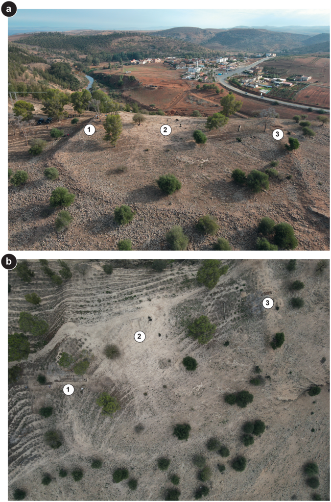
Oblique and vertical drone views of the Oued Beht fortified spur, showing the main excavation trenches and defensive walls. The village of Aït Siberne is visible in the background. Credit: L. Farr and G. Lucarini / Oued Beht Archaeological Project, via Libyan Studies, CC BY 4.0.
A mystery visible for nearly a century
The feature was not entirely unknown. In 1936, French archaeologist Armand Ruhlmann proposed that walls crossing the southern end of the ridge could have belonged to an éperon barré, a fortified spur in which a natural promontory is closed off by artificial defenses.
But the age of the structures remained uncertain. Later investigations encountered the visible walls without establishing when the earliest phases had been constructed, while more recent activity had further complicated the archaeological sequence.
The 2023 excavations targeted the largest of these features, known as Wall B1. What appeared on the surface to be a wall proved to hide something considerably more complex beneath it.
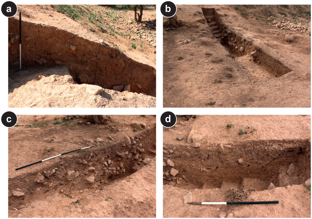
Archaeologists identified several phases of building, including an early wall or barrier, layers of deliberately constructed embankment and a ditch immediately to the north. The system crossed the ridge at a point where the natural terrain itself could help restrict access to the southern spur.
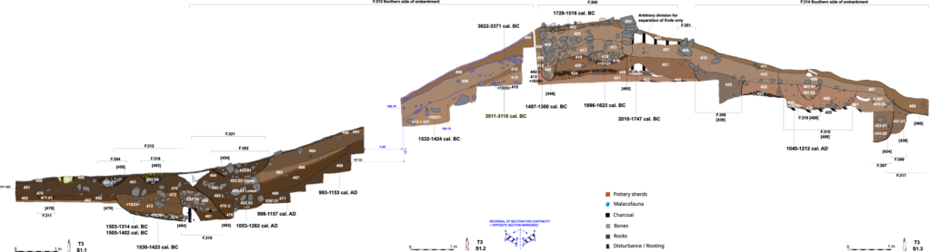
The ditch was at least 1.84 meters wide and 65 centimeters deep, although excavators did not reach its complete bottom profile. All 18 pottery sherds recovered from its excavated fills were prehistoric, while charred seeds from domesticated crops produced radiocarbon dates around 1500–1400/1300 BC.
Older construction lay nearby. Charcoal from the foundation of an early wall produced a date of 2010–1747 BC, while material associated with its destruction dated to 1896–1623 BC. Together, the dates reveal repeated construction and modification extending through much of the early and middle second millennium BC.
Not simply a stone wall
One of the more revealing details in the study is that the earliest defenses may have looked very different from the substantial stonework visible at Oued Beht today.
Beneath the later masonry, excavators encountered compacted gravel, charcoal-rich layers and both burned and unburned daub, suggesting that some early construction incorporated earth and organic materials. Two separate burning horizons indicate that the structure went through episodes of destruction or intense burning before subsequent rebuilding.
The earthwork itself also developed over time. Radiocarbon dates from its earliest securely dated northern phase fall around 1532–1424 BC and 1497–1300 BC, placing major additions to the rampart in the middle of the second millennium BC.
Much later, the same strategic line was reused. Medieval builders constructed substantial stone defenses over parts of the earlier earthwork, with radiocarbon evidence placing renewed activity between the 11th and 13th centuries AD. The surviving stone wall reaches about 2.3 meters wide at ground level and roughly 1.35 meters high in the excavated section.
Why the southern end mattered
The discovery becomes more significant when viewed against the changing geography of Oued Beht.
During the Final Neolithic, activity was concentrated across a broad northern area covering roughly 10 to 11 hectares. That settlement, dated mainly to the fourth millennium BC, has already been identified as the earliest and largest known agricultural complex of its period in Africa outside the Nile corridor.
By the second millennium BC, however, activity appears to have shifted toward the southern rocky spur. This area was naturally more protected, and blocking the ridge with an artificial barrier would have made access easier to control. The CNR researchers argue that constructing such a system implies a level of planning and organized labor not previously documented on this scale in the northwestern Maghreb.
There is one important qualification. The authors of the Libyan Studies paper consider a defensive interpretation persuasive because of the ditch, rampart, wall, and their position across the ridge, but they stop short of treating it as proven. A boundary intended to divide or enclose space remains possible, and the structure may have served different purposes during different periods.
That caution makes the discovery no less important. Instead, Oued Beht now preserves evidence for two very different prehistoric landscapes at the same place: an extensive farming community of the fourth millennium BC and, more than a thousand years later, a settlement whose inhabitants invested heavily in controlling and reshaping a naturally defensible ridge.
Lucarini G, Bokbot Y, Wilkinson T, et al. Expanding Oued Beht: Final Neolithic, Bronze Age, medieval and later discoveries from excavation and survey in 2023. Libyan Studies. Published online 2026:1-42. doi:10.1017/lis.2026.10037
