2 April 2026 The Future is the Product of the Past

The Oldest Known Map of Europe, “Saint-Bélec Slab”

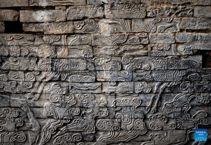
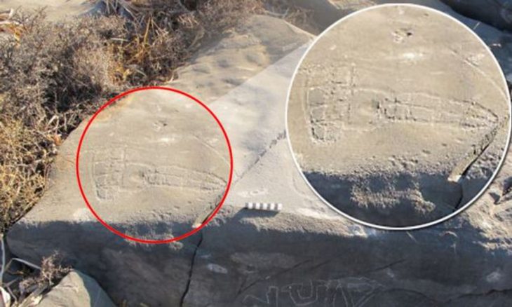
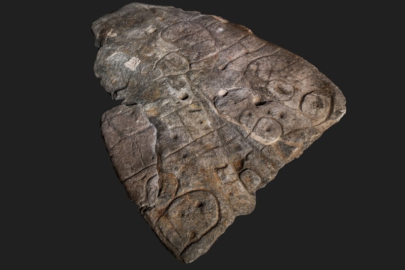
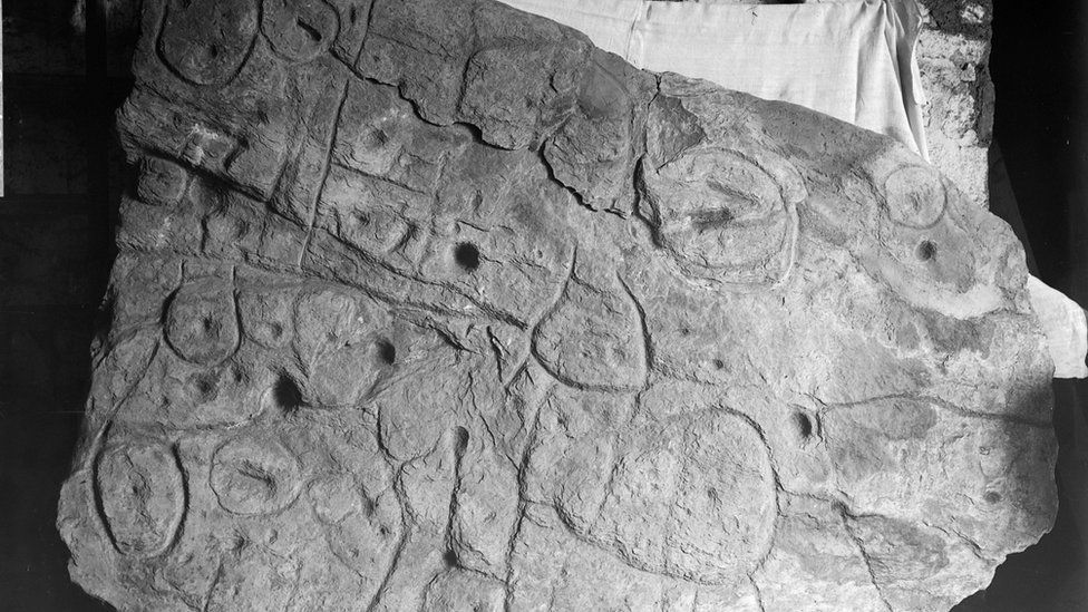
An ornate Bronze Age stone slab (Saint-Bélec slab) that was excavated in France in 1900 and forgotten about for over a century may be the oldest three-dimensional map in Europe.

In 2014, a 2m x 1.5m slab (5 feet x 6.5 feet) was again found in the cellar of a castle in Brittany, France. Archaeologists who study patterns carved on 4,000-year-old stones say they believe these marks are maps of the western region of Brittany. They say this makes the tablet the oldest 3D map of a known area in Europe.

Researchers examined the carved stone slab and dated it to the early bronze age. (MÖ 2150-1600)

Their research, published in the French journal Bulletin de la Société préhistorique française, identified it as the oldest cartographic representation of a known territory in Europe, a likely marker of the political power of the early Bronze Age.

The broken plate was reused for the burial of Saint-Bélec at the end of the Early Bronze Age (ca. 1900-1640 BC). At that time, the slab formed one of the walls of a stone cyst, a small coffin-like stone box used to contain the bodies of the deceased. His engraved face turned towards the inside of the tomb, but its ends were hidden. The plate was transferred to a private museum in 1900 before the collection was taken over by the Musée des Antiquités Nationales (MAN – Museum of National Antiquities) in 1924. Until the 1990s, the Saint-Bélec plate was kept in a niche in the castle cellar. Finally, in 2014, he was found in the castle’s basement.


📣 Our WhatsApp channel is now LIVE! Stay up-to-date with the latest news and updates, just click here to follow us on WhatsApp and never miss a thing!!


Saint-Belec Slab 1900
The slab was first discovered in Brittany in 1900.

The research team, including in 2017, began to perform high-resolution 3D research and plate photogrammetry, registering the surface of the plate and its engravings.

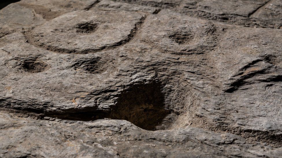
After analyzing the markings and carvings on the stone, the researchers suspected that it might be a map. A study in the Bulletin of the French Prehistoric Society stated that the “repetitive patterns connected by lines” on its surface indicate that it depicts a Finistère region. Researchers say that the dent is a 3D representation of the Odette River valley, and there appear to be several lines that delineate the river network in the area. The geographical location shows that the territory represented on the slab has an accuracy of 80% relative to the 18-mile-long area of ​​the river.

Markings on the rock are believed to depict an area of western Brittany.
Markings on the rock are believed to depict an area of western Brittany. Photo: DENIS GLIKSMAN

“This is probably the oldest map of a territory that has been identified,” Dr. Clément Nicolas from Bournemouth University, one of the study’s authors, told the BBC.

“There are several such maps carved in stone all over the world. Generally, they are just interpretations. But this is the first time a map has depicted an area on a specific scale.”

Dr. Nicolas said the map may have been used to mark a particular area.

“It was probably a way to affirm the ownership of the territory by a small prince or king at the time,” he said.

“We tend to underestimate the geographical knowledge of past societies. This slab is important as it highlights this cartographical knowledge.”

Saint-Bélec Slab is contemporary with the famous Nebra Nebula Disk discovered in Germany. It is the oldest known specific depiction of the cosmos and highlights the cartographic knowledge of prehistoric society.

Related Articles

The Oldest Basket in the World was Found in Israel

16 March 2021

16 March 2021

The Antiquities Authority announced on Tuesday that a large, well-preserved woven basket was found in the Jude Desert, with a...

The Most Important Works of Achaemenid Persian Metalwork “Oxus Treasure”

21 May 2021

21 May 2021

The Oxus Treasure is a collection of 180 precious metal objects unearthed on the north bank of the Oxus River...

A 3800-year-old cylinder seal was discovered at Turkey’s Tepebag Mound excavations

8 July 2022

8 July 2022

In the 2022 excavations of Tepebag Mound, located around Taşköprü, the center of Adana province in Turkey’s Mediterranean Region, a...

A first-of-its-kind Ayyanar stone idol found in Vellore, India

25 June 2022

25 June 2022

An Ayyanar stone idol, the first of its kind in Vellore, was discovered at Thandalai Krishnapuram (TK Puram) in Tamil...

A unique 2,800-year-old ivory-decorated piece was discovered in the Ancient City of Hattusa

13 November 2023

13 November 2023

An ivory-decorated piece, estimated to be approximately 2,800 years old, was found during the archaeological excavation in the Hattusa Ancient...

Scientists recreate Stone Age cave lighting

17 June 2021

17 June 2021

For early hunter-gatherer societies that were lucky enough to live near caves, these natural underground homes provided ideal protection from...

An ancient Roman road has been discovered in the Venice Lagoon

24 July 2021

24 July 2021

Researchers discovered a Roman road submerged in the Venice Lagoon. The finding suggests that substantial communities may have existed in...

Extraordinary Monumental Roman Burial Mound Discovered in Bavaria Stuns Archaeologists

18 October 2025

18 October 2025

Archaeologists in Bavaria have uncovered what appears to be the foundation of a monumental Roman burial mound, a discovery that...

Archaeologists Unearth 30 Neolithic Homes at Karahantepe, Revealing Daily Life and Diet of Early Settlers

18 October 2025

18 October 2025

Archaeologists working in Karahantepe, one of the major sites of the Taş Tepeler (Stone Hills) Project in southeastern Türkiye’s Şanlıurfa...

Kurt Tepesi: The Silent Sentinel in the Shadows of Göbeklitepe and Karahan Tepe – Unearthing the Forgotten Sister

31 May 2025

31 May 2025

In the arid plains of southeastern Anatolia, a quiet giant slumbers. While Göbekli Tepe has dazzled archaeologists and the global...

Mystery of the World’s Oldest Map on a Nearly 3,000-year-old Babylonian Tablet Finally Solved

28 October 2024

28 October 2024

A recent British Museum video reveals that the “oldest map of the world in the world” on a clay tablet...

Bronze Age artifacts discovered near the residence of ‘Iran’s Napoleon’

6 July 2021

6 July 2021

Archaeologists in Iran have discovered a plethora of artifacts and damaged structures near a former residence of Nader Shah, dubbed...

Poseidon’s Trident Discovered in Lake İznik

4 May 2025

4 May 2025

The depths of Lake İznik have yielded a discovery of profound significance, instantly captivating historians and archaeologists. The recent recovery...

5,000-year-old Ceremonial Temple Discovered in Peru

9 July 2024

9 July 2024

Archaeologists from the Peru Ministry of Culture have discovered an ancient ceremonial temple complex at Los Paredones de la Otra...

New Roman Settlement Discovered in Türkiye May Be Linked to the Lost City of Arsameia

17 October 2025

17 October 2025

Archaeologists in southeastern Türkiye have discovered a previously unknown Roman settlement dating to the 4th century AD — a site...