A vast, long-lost landscape may once have shaped the southern edge of historic Tabriz. Using declassified military aerial photographs and Cold War–era satellite imagery, researchers now say they have identified the remains of what could be one of the largest monumental Persian garden complexes ever documented in Iran, hidden for decades beneath modern urban expansion.
The findings, published online on January 30, 2026 by Cambridge University Press, are part of the Endangered Archaeology in the Middle East and North Africa (EAMENA) initiative, led by scholars from the universities of University of Oxford, University of Leicester, and Durham University, with support from the Arcadia Fund.
A Garden Lost to the Modern City
The site lies approximately six kilometers southeast of historic Tabriz, on land that began to be rapidly urbanized in the early 1990s. Today, apartment blocks, highways, and modern infrastructure dominate the area. But earlier images tell a very different story.
By carefully analyzing Royal Air Force reconnaissance photographs taken in August 1941—during the Anglo-Soviet invasion of Iran—and comparing them with U.S. KH-7 Gambit satellite imagery from 1967, researchers reconstructed the faint but coherent outline of a massive enclosed landscape. When georeferenced and mapped using GIS technology, the pattern revealed a highly structured complex unlike ordinary agricultural land.
The researchers argue that the scale, organization, and water features strongly point to a formal Persian garden, possibly dating to the Safavid or Qajar periods, between the 16th and early 20th centuries.
📣 Our WhatsApp channel is now LIVE! Stay up-to-date with the latest news and updates, just click here to follow us on WhatsApp and never miss a thing!!
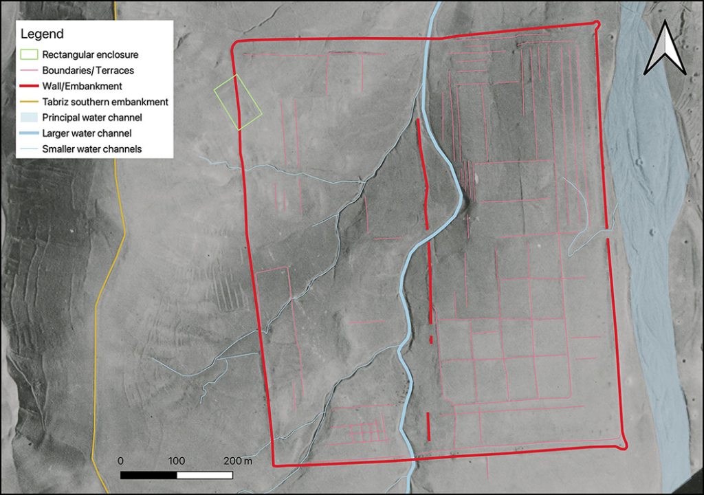
Basic mapping of the visible garden features (figure by authors). Credit: Fradley et al., Antiquity (2026)
Inside the Enclosure
At its fullest extent, the complex appears to have covered nearly half a square kilometer. A substantial rectangular embankment enclosed the site, with what seems to have been a formal eastern façade marked by a central entrance and circular corner features reminiscent of defensive turrets seen in elite garden architecture.
Within the enclosure, the eastern half displays a strikingly regular layout: rectangular garden plots arranged in a grid, separated by low banks or walls. Individual plots measure roughly 50–55 meters by 65–75 meters, suggesting careful planning rather than ad hoc cultivation. Long, narrow terraces—around 10 meters wide—run along parts of the outer interior, reinforcing the impression of a formally designed landscape.
The western section, by contrast, follows rising terrain and shows a looser arrangement. Here, several small tributary channels feed into a winding watercourse, with fewer visible structural divisions. Researchers interpret this contrast as intentional, possibly reflecting different aesthetic or functional zones within the garden.
Water, Power, and Prestige
Water management lies at the heart of Persian garden design, and the newly identified site is no exception. A meandering central channel divides the complex, while smaller streams shape the western section. Interestingly, these water features appear largely non-canalized, flowing naturally rather than being rigidly engineered.
This combination—strict rectilinear garden bays set alongside freer watercourses—may represent a distinctive regional adaptation of Persian garden principles. The researchers suggest that a monumental building may once have stood on the elevated western ground, overlooking the formal garden plots below.
The site’s location adds further weight to its interpretation. It lies just 800 meters from El-Goli (Shah Goli), a well-known historic water garden dating at least to the early 18th century. Together, the two complexes may have formed part of a broader elite landscape on the outskirts of Tabriz.
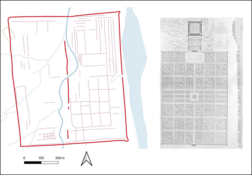
The layout of the garden site compared to that of the Qasr-i Qajar at roughly the same scale (source: EAMENA; Coste Reference Coste1867). Credit: Fradley et al., Antiquity (2026)
Tabriz, the “Garden City”
Historical sources describe Tabriz as a city of gardens as early as the 14th century, earning it the epithet “Garden City.” Several historic gardens—such as Bagh-e Shomal and the Sahebabad Garden—are known from texts and maps. Yet no prior records mention a garden of this scale at the newly identified location.
Comparisons drawn in the study link the layout to famous Persian gardens elsewhere in Iran, including the Fin Garden in Kashan and the vast Hezar-Jarib garden complex of Isfahan. While those sites are better preserved or historically documented, the newly identified Tabriz complex may rival them in ambition.
Rediscovered from the Air
By the early 1990s, satellite imagery shows that urban expansion had largely erased surface traces of the garden. A road cut through the site and was later widened into a highway around 2010. Construction intensified after 2014, though pockets of parkland still survive.
Crucially, researchers note that subsurface archaeological deposits may remain intact in some areas, depending on how modern construction was carried out. If so, future investigations could yet recover physical evidence of this lost landscape.
Fradley MG, Rouhani B, Hopper K. A monumental garden complex in Tabriz, Iran. Antiquity. Published online 2026:1-7. doi:10.15184/aqy.2026.10289
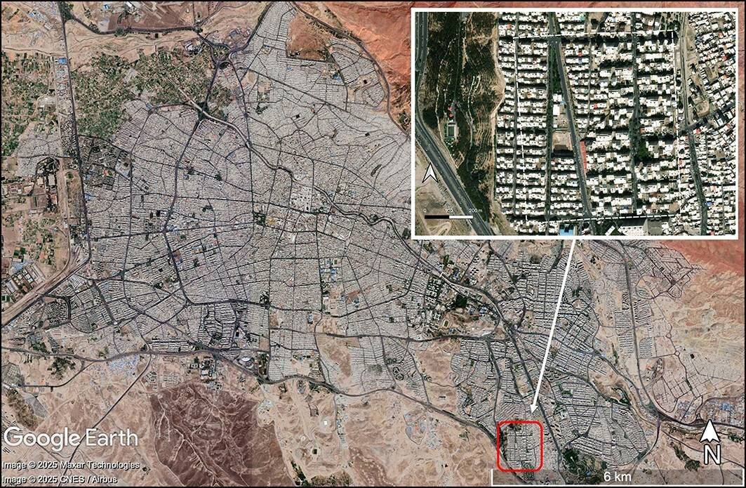
Cover Image Credit: Satellite imagery showing expanse of modern Tabriz in 2022, with inset detail of the modern development on the garden site (source: Maxar and Airbus, via Google Earth). Fradley et al., Antiquity (2026)