Recent research by a multidisciplinary team of archaeologists and geologists has revealed that the Eridu region of southern Mesopotamia, inhabited from the sixth to the first millennium BCE, boasts one of the oldest and most well-preserved irrigation networks.
Led by geoarchaeologist Jaafar Jotheri from Durham University, the research team uncovered an extensive water management system that predates the first millennium BC, offering valuable insights into the irrigation practices of ancient farmers.
The Eridu region of southern Mesopotamia, located in present-day Iraq, is one of the best-preserved ancient archaeological sites, having been occupied from the sixth until the early first millennium BC. While our understanding of the irrigation and farming methods used in this ancient city has largely relied on indirect evidence, such as cuneiform tablets, recent research has revealed a vast and well-developed network of irrigation canals that predates the early first millennium BC.
Historically, Mesopotamia depended on the Euphrates River and its tributaries for crop irrigation, with the ability to divert water through canals being crucial for the sustainability of urban settlements. However, many ancient irrigation structures have been buried under fluvial sedimentation or replaced by later networks, complicating the study of early agricultural systems.
In contrast to other regions, the Eridu area was abandoned following a shift in the Euphrates River’s course, allowing its archaeological landscape to remain relatively intact. This unique circumstance has enabled researchers to accurately identify and map a complex network of artificial canals that dates back to before the first millennium BCE, shedding new light on the region’s ancient water management practices.
📣 Our WhatsApp channel is now LIVE! Stay up-to-date with the latest news and updates, just click here to follow us on WhatsApp and never miss a thing!!
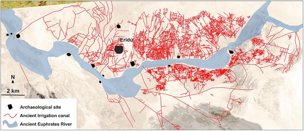
Unlike other regions, the Eridu area was abandoned following a shift in the Euphrates River’s course, which allowed its archaeological landscape to remain remarkably intact. This unique situation has provided researchers with the opportunity to accurately identify and map a complex network of artificial canals that predates the first millennium BCE.
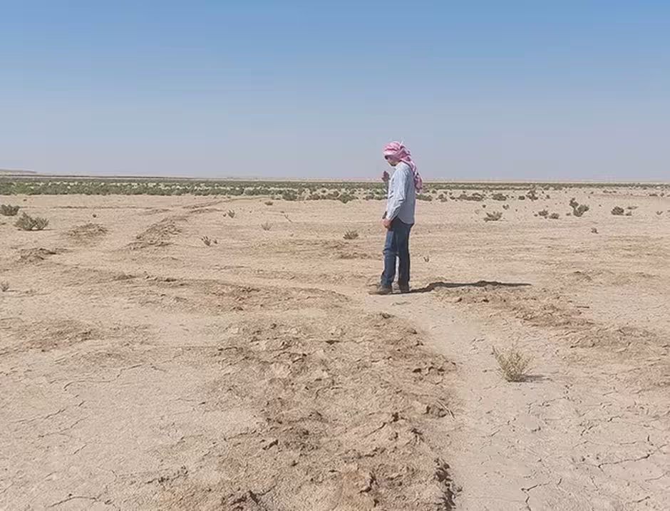
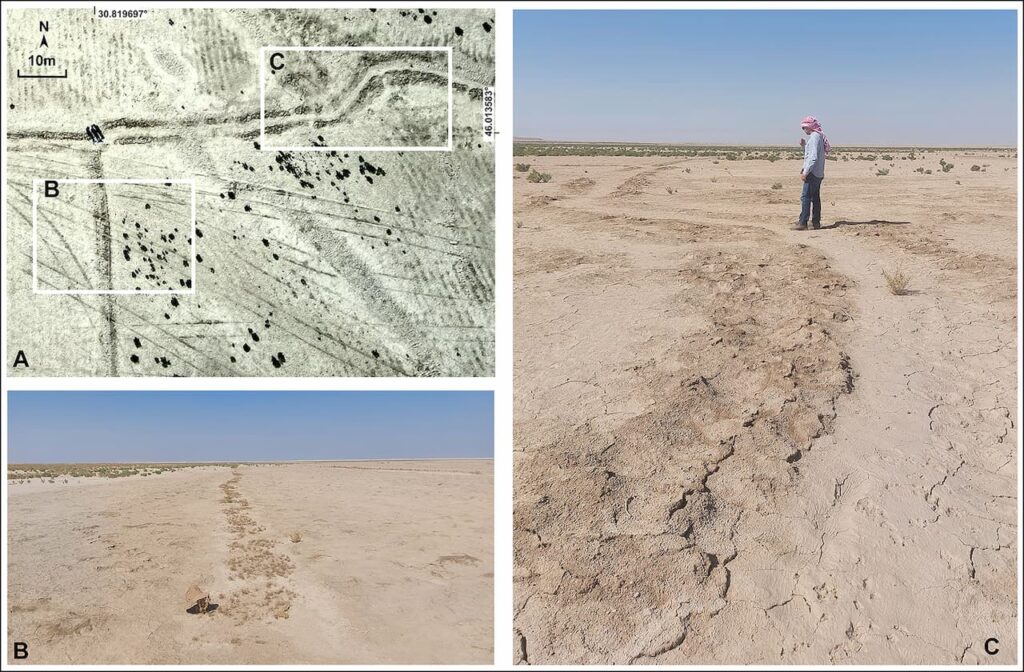
To conduct this study, archaeologists employed an interdisciplinary approach that combined geomorphological analysis, historical map reviews, and advanced remote sensing technology. They utilized high-resolution satellite imagery, including data from the 1960s CORONA program, as well as drones and ground photography, to validate their findings and enhance the understanding of this ancient irrigation system.
By combining geological maps, satellite imagery, drone photography and fieldwork, researchers identified over 200 primary canals directly connected to the ancient Euphrates. Additionally, more than 4,000 smaller branch canals were mapped, linked to over 700 farms.
This complex irrigation network showcases the advanced water management skills of ancient Mesopotamian farmers, who skillfully utilized the natural landscape to their advantage. The high river levees facilitated the flow of water by gravity to surrounding fields, while breaks in the levees, known as crevasse splays, effectively distributed water across the floodplain. These techniques enabled farmers to cultivate crops on both sides of the river, although the northern side was more heavily farmed. This observation underscores the strategic utilization of the region’s resources to enhance agricultural productivity.
The study also emphasizes the evolution of the irrigation system over centuries, indicating that the canals necessitated considerable labor and expertise for their maintenance, which suggests that different segments of the network were likely utilized at various times. To gain a deeper understanding of the changes in farming practices over time, further research aims to date each canal. Additionally, comparing the designs of these canals with descriptions found in ancient cuneiform texts could yield valuable insights into agricultural management in Mesopotamia.
The project was funded by the British Institute for the Study of Iraq in London and is a collaboration between Durham, the University of Al-Qadisiyah in Iraq and Newcastle University, UK.
Jotheri J, Rokan M, Al-Ghanim A, Rayne L, de Gruchy M, Alabdan R. Identifying the preserved network of irrigation canals in the Eridu region, southern Mesopotamia. Antiquity. Published online 2025:1-7. doi:10.15184/aqy.2025.19
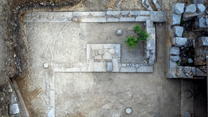
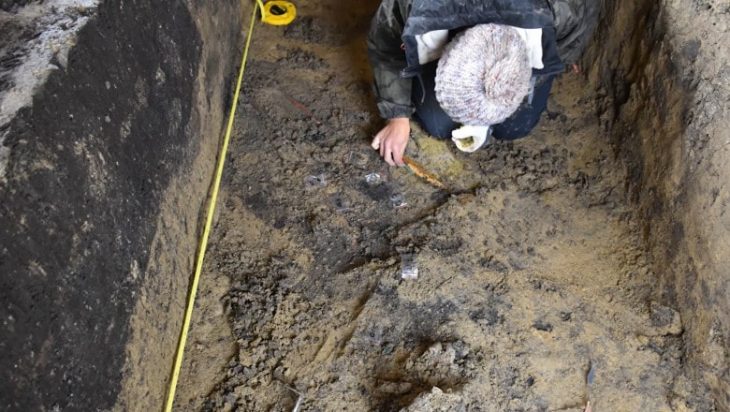
Cover Image Credit: Remnants of small canals in Eridu. Credit: Jaafar Jotheri et al, Antiquity/Durham University