9 December 2025 The Future is the Product of the Past

Roman road network spanning the South West of England identified in new research

A Roman road network spanning across Devon and Cornwall has been discovered by the University of Exeter archaeologists.

A Roman road network that spanned Devon and Cornwall and connected significant settlements with military forts across the two counties as well as wider Britannia has been discovered for the first time.

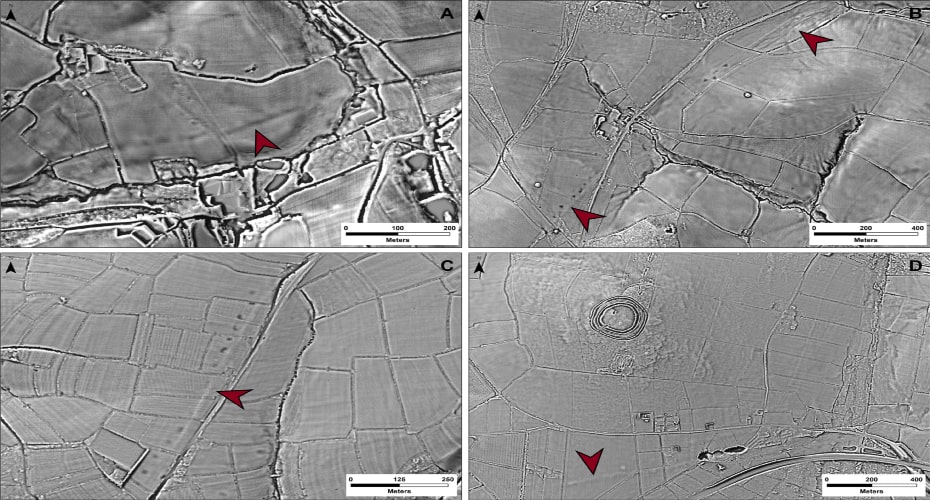
Archaeologists have used laser scans to identify new sections of road west of the previously understood boundary. Using sophisticated geographical modelling techniques, which incorporate information around gradients and flood risk, the researchers have then been able to map out the full extent of the network and begin to understand the rationale for its existence.

Among the things it reveals is that far from Exeter being the main nerve centre of the network, it was North Tawton that supported strategically vital connections with tidal estuaries north and south of Bodmin and Dartmoor.

These findings are explored in Remote Sensing and GIS Modelling of Roman Roads in South West Britain, which has been published in the Journal of Computer Applications in Archaeology.


📣 Our WhatsApp channel is now LIVE! Stay up-to-date with the latest news and updates, just click here to follow us on WhatsApp and never miss a thing!!


The research was led by Dr Christopher Smart and Dr Joao Fonte, specialists in landscape archaeology and the heritage of the Roman Empire, in Exeter’s Department of Archaeology and History.

Primary and secondary nodes in the study area. Photo: University of Exeter

“Despite more than 70 years of scholarship, published maps of the Roman road network in southern Britain have remained largely unchanged and all are consistent in showing that west of Exeter, Roman Isca, there was little solid evidence for a system of long-distance roads,” said Dr Smart.

“But the recent availability of seamless LiDAR coverage for Britain has provided the means to transform our understanding of the Roman road network that developed within the province, and nowhere more so than in the far south western counties, in the territory of the Dumnonii.”

The National LiDAR Programme was conducted between 2016 and 2022 by the Environment Agency covering the whole of England. It transformed the amount of terrain mapped of Devon and Cornwall, which had previously stood at just 11%. The Exeter team studied the scans and together they were able to map around 100km of additional roads.

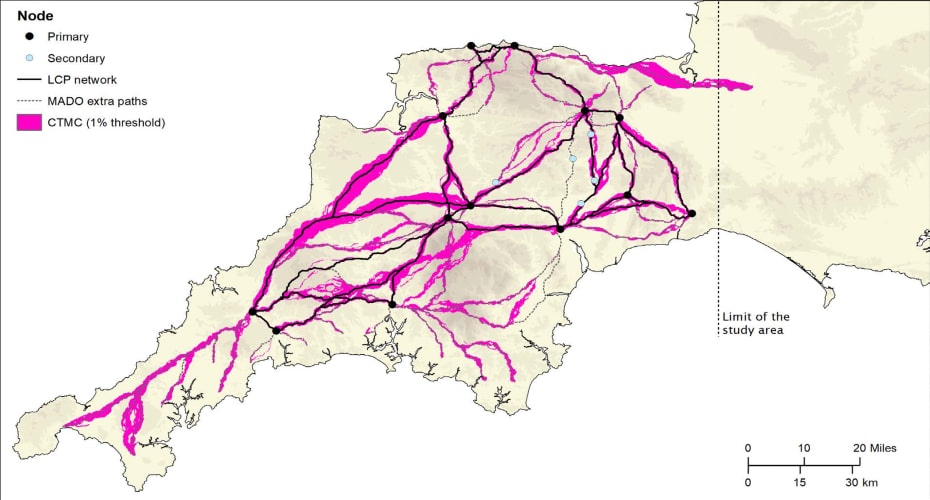
Although this represented a significant advancement, the overall picture remained fragmented and patchy, with large portions of the map showing no evidence of Roman roads. The team developed a geographic information system predictive model, which could intelligently fill in the gaps as to the likely layout of the network.

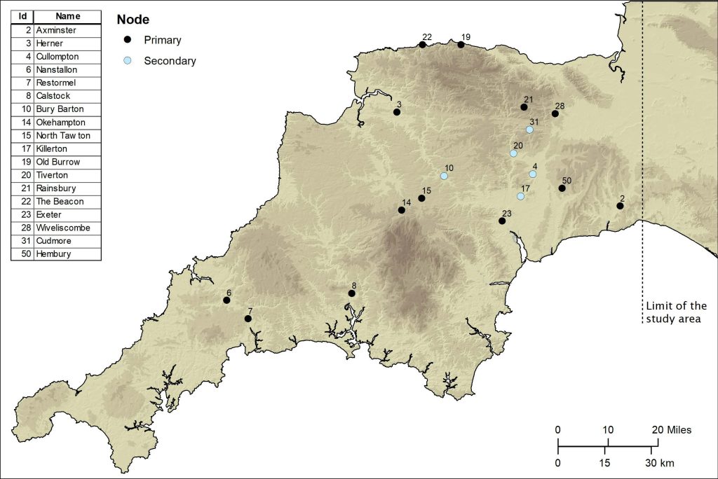
They plotted primary and secondary “nodes” across the two counties, which included permanent military fortifications, including the known forts of Old Burrow and The Beacon at Martinhoe, as well as the settlements at Exeter and North Tawton. They then calculated the easiest routes between these points.

Examples of segments of Roman roads identified from the LiDAR-derived terrain models provided by Environment Agency’s ‘National LiDAR Programme'. Photo: University of Exeter
Examples of segments of Roman roads identified from the LiDAR-derived terrain models provided by Environment Agency’s ‘National LiDAR Programme’. Photo: University of Exeter

And when the team returned to the LiDAR scans, they were able to identify a further 13km of Roman road within a short distance predicted by the model.

The final stage saw the researchers use focal mobility networks and transit corridors to extend the road network to areas that lay beyond the main Roman sites known in the region.

“In terms of chronology, it is likely that the proposed network is an amalgam of pre-existing Prehistoric routeways, Roman military campaign roads or ‘tactical roads’ formally adopted into the provincial communications system, and of those constructed during peacetime in a wholly civilian context,” said Dr Fonte.

“This evolutionary model is supported by the fact that the network does not solely connect Roman forts and their hinterlands directly, which are often connected by branch roads, but instead appears to serve a broader purpose than required by military supply.”

The research concludes that the main rationale for the network was to facilitate animal-drawn vehicles and circumvent those areas where flooding was possible. It could also influence, say the authors, future archaeological research in the region.

University of Exeter

Related Articles

1,500-year-old feast mosaic found in Turkey

2 February 2022

2 February 2022

A 50-square-meter mosaic depicting an open-air feast dating back 1,500 years ago was unearthed during excavations in the ancient city...

50 Lost War Helmets Found Near Wrocław University

16 June 2025

16 June 2025

In a remarkable archaeological discovery, over 50 military helmets from both World Wars have been unearthed just steps away from...

Traces of Pozzolan Dust from Phlegraean Fields Found in a 1st-Century Roman Hydraulic Structure Submerged in Venetian Lagoon

29 November 2024

29 November 2024

In the San Felice Canal, in the northern Venetian Lagoon, a material used as an additive in Roman concrete was...

3000 years old wooden wishing well discovered in Germany

7 January 2023

7 January 2023

In the town of Germering, in the Germany state of Bavaria, archaeologists have unearthed the remains of a well-preserved Bronze...

Famous  Roman Dictator Julius Caesar’s Perfume Recreated

2 August 2024

2 August 2024

The Romans are long regarded as heroes in the history of ancient civilizations because of the legacy they have left...

Unique Gems found in Claterna, known as the ‘Pompeii of the North’

18 November 2023

18 November 2023

Italian archaeologists have unearthed 50 unique jewels during ongoing excavations at Claterna, the ancient Roman site known as the ‘Pompeii...

The Discovery of a Bronze Age Game Board in Azerbaijan Challenges the Origin of One of the World’s Oldest Games

30 August 2024

30 August 2024

A new archaeological study revealed that an ancient board of a game, known as “Hounds and Jackals” or the “Game...

World’s Oldest Arrow Poison Discovered in South Africa, Dating Back 7,000 Years

27 January 2025

27 January 2025

In a groundbreaking discovery, archaeologists excavating Kruger Cave in South Africa have identified what may be the oldest confirmed multi-component...

Stone-arched tunnel discovered near Achaemenid dam in southern Iran

4 February 2022

4 February 2022

A cultural heritage protection team has recently discovered a stone-arched tunnel located near an Achaemenid embankment dam in southern Iran....

An 1800-year-old geometric patterned mosaic was discovered in Turkey’s ancient city of Bergama

17 June 2022

17 June 2022

During excavations surrounding the Red Basilica at Pergamon, an ancient city in western Turkey that is a UNESCO World Heritage...

A fossilized Neanderthal skeleton unearthed in France may have belonged to a previously undescribed lineage that split from other Neanderthals

12 September 2024

12 September 2024

The fossilized Neanderthal skeleton, discovered in a cave system in the Rhône Valley of France, represents a previously unidentified lineage...

Game Bone Stones from a Roman Military Strategy Game Found in Hadrianopolis Ancient City, Türkiye

10 January 2025

10 January 2025

During the excavations in Hadrianopolis Ancient City in Eskipazar district of Karabük, 2 bone game stones belonging to the military...

Neanderthal Footprints Discovered On the Beach of Matalascañas (Huelva)

4 May 2021

4 May 2021

A stroll along the beach of Matalascanas (Huelva) in June of last year unearthed a spectacular scenario that occurred in...

Aramaic four inscriptions found for the first time in eastern Turkey

17 September 2022

17 September 2022

Four inscriptions written in Aramaic were discovered in the ancient city with a grid plan, located on an area of...

Archaeologists have unearthed a flawless Roman blue glass bowl in the Dutch city of Nijmegen

23 January 2022

23 January 2022

Archaeologists excavating the site of a comprehensive housing and green space development in Nijmegen’s Winkelsteeg, one of the oldest cities...