23 July 2025 The Future is the Product of the Past

Digitally Reconstructed: Roman Roads That Shaped 1,000 Years of Travel Across Medieval Britain

Researchers digitally reconstruct medieval England and Wales’ travel routes, revealing how Roman roads shaped post-Roman mobility over a thousand years.

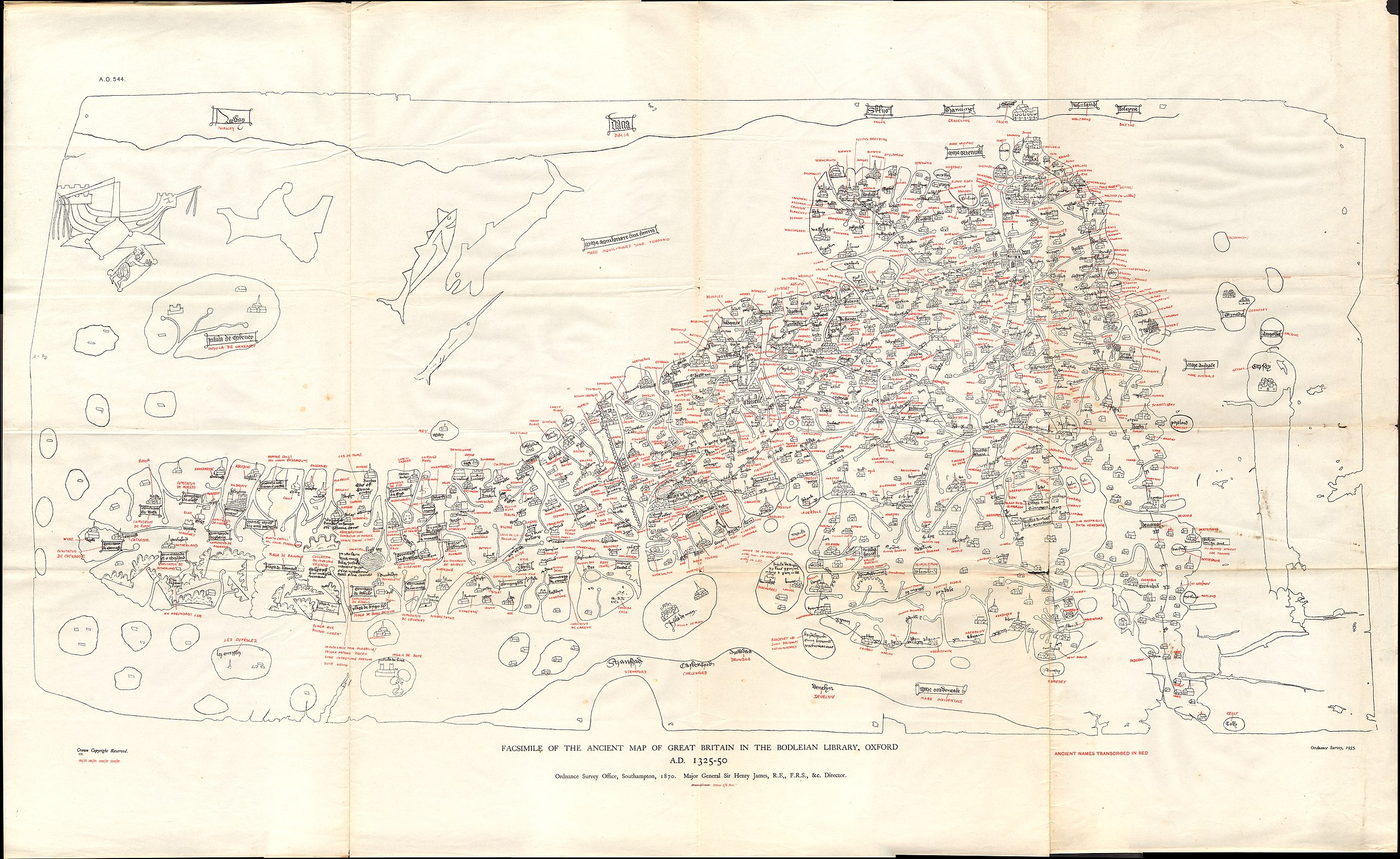
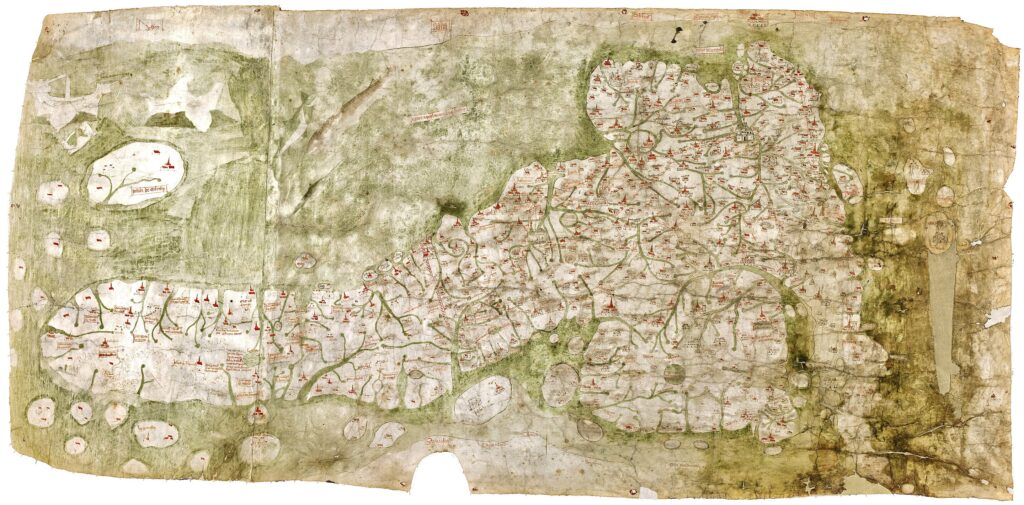
A team of historians and digital archaeologists has unveiled a pioneering Geographic Information Systems (GIS) database that reconstructs travel and communication routes in medieval England and Wales — using the enigmatic Gough Map, a 15th-century cartographic artifact long shrouded in mystery.

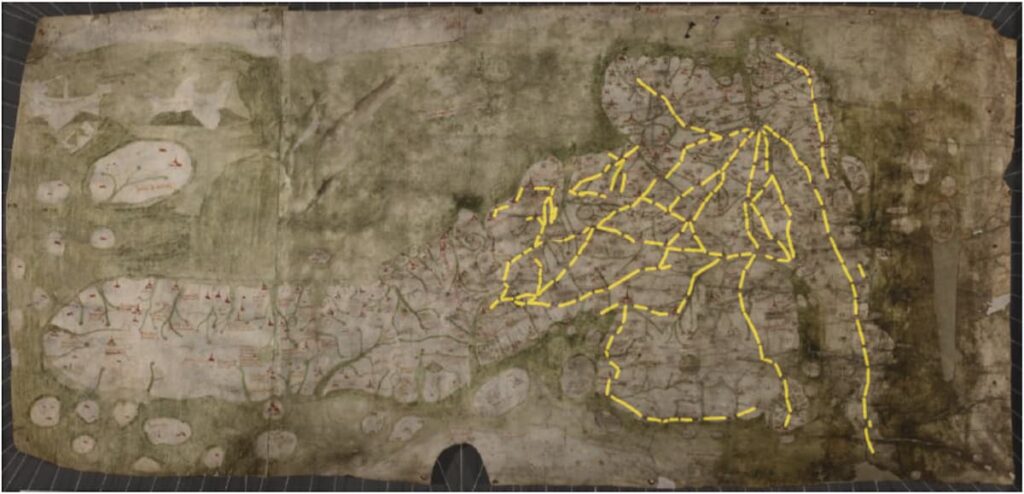
Their work centers on the red lines etched into the Gough Map, which the team argues represent actual medieval roads and travel routes connecting towns, rivers, and regions across Britain. Far from being mere artistic flourishes, these lines now appear to be the earliest surviving representation of a complex overland route network in the British Isles.

By analyzing these lines through archaeological, linguistic, documentary, and environmental evidence, and comparing them with surviving Roman roads, the researchers reveal the deep and uneven legacy of Roman infrastructure in shaping post-Roman and medieval mobility.

The Gough Map. Credit: Public Domain

Where Rome Ends and the Middle Ages Begin

The study dives into which parts of the Roman road system persisted, and why. Some regions, like the Thames Valley, saw Roman routes fade due to a shift toward river transport and geopolitical turmoil. In contrast, towns like London, Winchester, and Leicester, which retained their Roman urban cores, show a strong correlation between Gough Map routes and ancient Roman roads.

However, in places where Roman towns were abandoned or replaced, such as Old Sarum (later Salisbury) and Venta Icenorum (near modern Norwich), road continuity was weaker or vanished altogether. The researchers emphasize that no single factor explains this—road survival was a complex interplay of political, geological, economic, and highly localized human decisions.

From Red Lines to Digital Insights

This study builds on earlier digitization projects and delivers a new open-access GIS database that captures the Gough Map’s travel networks in digital form. More than a historical curiosity, the project demonstrates the potential of combining ancient maps with modern technology to uncover broad socio-economic patterns that influenced how people moved, traded, and interacted during the medieval period.

The Gough Map, with the ‘red lines’ highlighted in yellow. Credit: Linguistic Geographies and The Bodleian Libraries, University of Oxford

The approach also aligns with pan-European initiatives like Viabundus and Itiner-e, which aim to digitally reconstruct historical travel networks across borders. These collaborations promise to transform the study of mobility and infrastructure from antiquity through the early modern era.

A Thousand Years of Routes—and Decisions

Ultimately, this research reframes our understanding of medieval travel. The persistence of ancient routes wasn’t dictated solely by empire or economy but by countless micro-decisions made by people navigating their world — choosing paths based on soil, crops, politics, safety, and settlement.

In revealing how these decisions played out over centuries, the study not only recovers lost paths — it reconnects us to the lived geography of the past.

Eljas Oksanen, Stuart Brookes, The afterlife of Roman roads in England: insights from the fifteenth-century Gough map of Great Britain. Journal of Archaeological Science. Volume 179, July 2025, 106227. doi.org/10.1016/j.jas.2025.106227

Cover Image Credit: Facsimile of the Gough Map by the Ordnance Survey. First published in 1870, the red transcriptions of ancient names were added in the 1935 edition. Credit: Public Domain

Related Articles

Thousand-year-old bone skate discovered in Czech Republic

20 March 2024

20 March 2024

Archaeologists from the central Moravian city of Přerov, Czech Republic have announced a unique discovery. While carrying out excavations in...

Archaeologists have unearthed part of Hadrian’s Aqueduct, one of the Largest Hydraulic Works of the 2nd century AD, and Extremely Rare Greek Coins

11 January 2024

11 January 2024

Archaeologists have unearthed part of Hadrian’s aqueduct, one of the largest hydraulic works of the 2nd century AD, and a...

A rare 2,500-year-old shipwreck found off the Greek island of Kythera

5 November 2021

5 November 2021

A rare shipwreck from the ancient era was discovered during the maritime survey for the Crete-Peloponnese subsea link. The Independent...

Only Those on the Righteous Path May Enter Here”: New Mosaics Unearthed in Antalya’s Olympos

19 June 2025

19 June 2025

A newly discovered mosaic inscription at the entrance of a church and elaborately decorated floor mosaics have come to light...

Archaeologists unearthed fresh evidence that bedbugs came to Britain with the Romans

3 February 2024

3 February 2024

Archaeologists working the Roman garrison site of Vindolanda in Northumberland, south of Hadrian’s Wall, have discovered new proof that the...

Human Presence in Malta Earlier Than Previously Thought: Hunter-Gatherers Navigated 100 km by Sea 1,000 Years Before Farmers

14 April 2025

14 April 2025

Recent archaeological findings have dramatically reshaped our understanding of human history in the Mediterranean, revealing that hunter-gatherers were capable of...

New Discoveries Made in World’s Oldest Ancient Shipyard

11 June 2024

11 June 2024

Associate Professor Hakan Öniz, who discovered the world’s largest and oldest shipyard dating back to the Bronze Age in 2015...

Researchers believe mass immigration to Orkney during the Bronze Age was mostly led by women

8 February 2022

8 February 2022

Researchers believe mass immigration to Orkney during the Bronze Age was mostly led by women.  Mass migration to Orkney during...

Roman soldier’s 1,900-year-old payslip uncovered in Masada

16 February 2023

16 February 2023

During excavations at Masada, archaeologists from the Israel Antiquities (IAA) uncovered a papyrus payslip dated to 72 BC belonging to...

The Mountain of Shemharus, King of the Ginn: Toubkal

14 August 2022

14 August 2022

Towering over the Atlas Mountains, Mount Toubkal is the highest peak in Morocco. Toubkal, the highest mountain in all of...

1,300-year-old shipwreck found in southwest France

19 June 2022

19 June 2022

Archeologists in France have discovered the wreck of a ship that navigated the Garonne river in southwestern France in the...

Native American artifacts from 1100 AD found in North America’s First City

20 June 2024

20 June 2024

Cahokia is the largest and most significant urban settlement of the Mississippian culture, known for creating massive earthen platform mounds...

Archaeologists Discover Prehistoric Irish Monuments That May Have Been ‘Routes For The Dead’

27 April 2024

27 April 2024

Traces of hundreds of monuments, which were previously unknown, have been identified in an archaeological survey in Ireland. Five of...

11,000-Year-Old LSU Campus Mounds Are Oldest Known Human-Made Structures In North America

23 August 2022

23 August 2022

According to new research published in the American Journal of Science, two six-meter (20-foot) high mounds on the campus of...

Roman girl adorned with 1800-year-old jewelry found in a lead coffin on Mount Scopus

9 April 2023

9 April 2023

“After the destruction of the Jerusalem Temple and the exodus of the Jewish population, late Roman Jerusalem—renamed Aelia Capitolina—had a...