11 May 2025 The Future is the Product of the Past

Maya Farmers May Have Planned Population Growth Contrary to Thought

Contrary to what was thought, Maya farmers may have planned for population growth, says a new study.

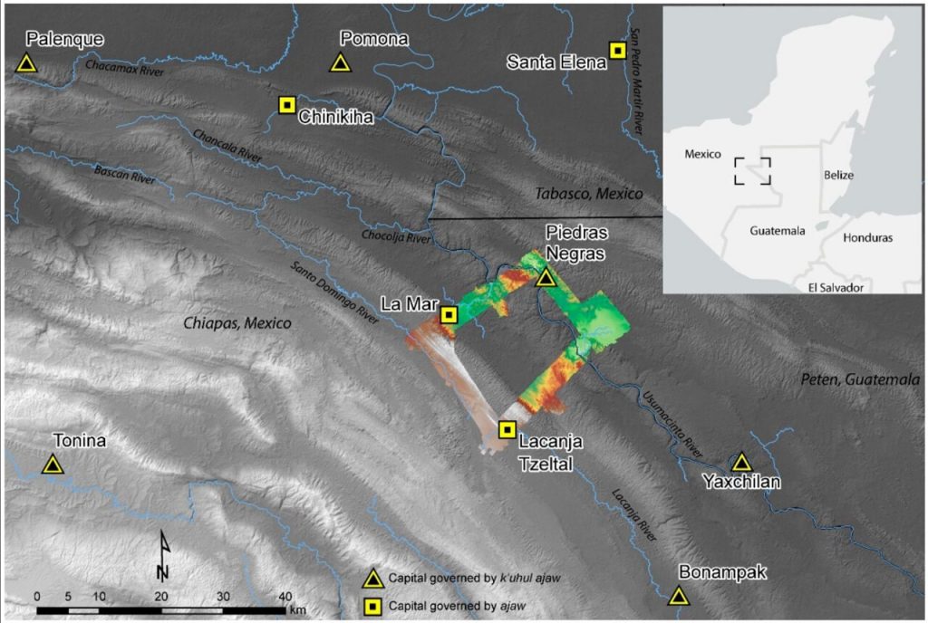
According to a Brown University press release, Andrew Scherer of Brown University and Charles Golden of Brandeis University, together with their colleagues, undertook a lidar survey of a stretch of the Western Maya Lowlands on the border between Mexico and Guatemala.

“It’s exciting to talk about the really large populations that the Maya maintained in some places; to survive for so long with such density was a testament to their technological accomplishments,” Scherer said. “But it’s important to understand that that narrative doesn’t translate across the whole of the Maya region. People weren’t always living cheek to jowl. Some areas that had the potential for agricultural development were never even occupied.”

The Maya urban centers of Piedras Negras, La Mar, and Lacanja Tzeltal, the capital of the kingdom of Sak Tz’i’, are located in this region.

Scherer explained that all three kingdoms were governed by an ajaw, or a lord — positioning them as equals, in theory. But Piedras Negras, the largest kingdom, was led by a k’uhul ajaw, a “holy lord,” a special honorific not claimed by the lords of La Mar and Sak Tz’i’. La Mar and Sak Tz’i’ weren’t exactly equal peers, either: While La Mar was much more populous than the Sak T’zi’ capital Lacanjá Tzeltal, the latter was more independent, often switching alliances and never appearing to be subordinate to other kingdoms, suggesting it had greater political autonomy.

The lidar showed evidence of expansive irrigation channels across the region. The depression with dark soil shows the remains of an ancient channel.

The lidar survey showed that, despite their differences, these three kingdoms boasted one major similarity: agriculture that yielded a food surplus.

“What we found in the lidar survey points to strategic thinking on the Maya’s part in this area,” Scherer said. “We saw evidence of long-term agricultural infrastructure in an area with relatively low population density — suggesting that they didn’t create some crop fields late in the game as a last-ditch attempt to increase yields, but rather that they thought a few steps ahead.”

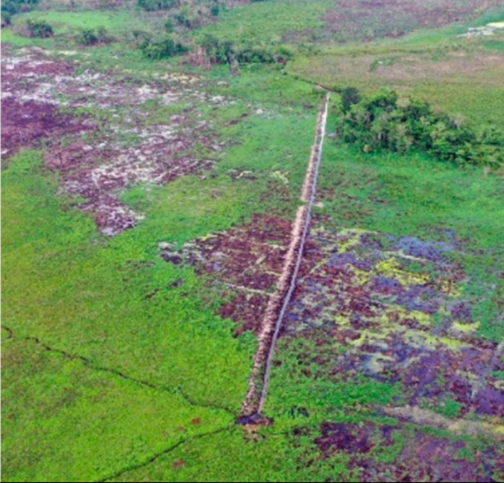
Remote sensing technology indicated that between A.D. 350 and 900, the Maya built irrigation channels and terraces in and around the region’s towns, despite no indications of comparable expansion in the population centers.

The lidar indicated signals of “agricultural intensification” — the alteration of land to boost the volume and predictability of crop production — in all three kingdoms. In ancient Maya kingdoms, where maize was the principal crop, agricultural intensification strategies included constructing terraces and developing water control systems with dams and channeled fields. The lidar, which penetrated the often-dense jungle, revealed substantial terracing and vast irrigation systems across the region, indicating that these kingdoms were not only prepared for population increase but also likely had food surpluses every year.

The research team surveyed a small area in the Western Maya Lowlands situated at today’s border between Mexico and Guatemala, shown in context here.

Maya farmers, the researchers explained, may have intended to produce surplus crops and prepare for population growth. Surplus food may have been sold in marketplaces as staples or as prepared food, Scherer added.

Today, Scherer said, significant parts of the region are being cleared for cattle ranching and palm oil plantations. But in areas where people still raise corn and other crops, they report that they have three harvests a year — and it’s likely that those high yields may be due in part to the channeling and other modifications that the ancient Maya made to the landscape.

“In conversations about contemporary climate or ecological crises, the Maya are often brought up as a cautionary tale: ‘They screwed up; we don’t want to repeat their mistakes,’” Scherer said. “But maybe the Maya were more forward-thinking than we give them credit for. Our survey shows there’s a good argument to be made that their agricultural practices were very much sustainable.”

The research group’s findings were published in the journal Remote Sensing.

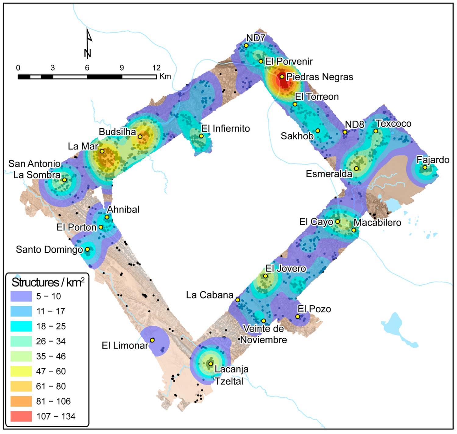
Cover Photo: Lidar scans of the research area revealed the relative density of structures in Piedras Negras, La Mar, and Lacanjá Tzeltal, providing hints at these cities’ respective populations and food needs.The Brown University

The Brown University

Related Articles

A 1,100-year-old lead amulet of Bulgarian soldiers sieges Constantinople found

31 March 2023

31 March 2023

A lead plate amulet bearing an inscription in Cyrillic dating from the times of Tsar Simeon the Great was discovered...

The 1,000-year-old surgical kit found in Sican tomb, Peru

28 March 2022

28 March 2022

A set of surgical tools indicating that the deceased was a surgeon was found in a funerary bundle found in...

The oldest meerschaum artifact found in Anatolia; of Çavlum Seal

18 July 2021

18 July 2021

The stamp seal unearthed during the rescue excavations of Çavlum Village on the Eskişehir Alpu Plain is the oldest meerschaum...

Isotopic Evidence reveals surprising dietary practices of pre-agricultural human groups in Morocco

30 April 2024

30 April 2024

It has long been accepted wisdom that hunter-gatherer societies lived primarily off of meat. But fresh data from an innovative...

An Ancient Building and Gold Artifacts Found in the Ancient Greek City of Rypes in Achaea

10 December 2024

10 December 2024

Recent excavations on the Trapezá plateau, eight kilometers southwest of the city of Aigio in the Peloponnese, have uncovered an...

A Female Elite Tomb in a Yellow Silk Cloak from the Pre-Mongolian Period Discovered in Mongolia

13 August 2024

13 August 2024

A recent archaeological excavation in Mongolia’s Dornod Province revealed an elite tomb embedded in the walls of an abandoned fortress...

First European farmers’ heights did not meet expectations

9 April 2022

9 April 2022

A combined study of genetics and skeletal remains shows that the switch from primarily hunting, gathering and foraging to farming...

3,000-year-old ‘charioteer belt’ discovered in Siberia

21 July 2023

21 July 2023

Russian archaeologists uncovered the grave of a Late Bronze Age man buried wearing a “charioteer’s belt”, a flat bronze plate...

Unique 7,700-year-old figurines were discovered in Ulucak Mound, one of the oldest settlements in Western Anatolia

6 October 2023

6 October 2023

Ulucak Mound (Ulucak Höyük), one of the oldest neolithic settlements dating back to 6800 BC, male and female figurines evaluated...

In Poland, a 45-meter-long mysterious tunnel found under the ruins of the Saxon Palace

9 September 2023

9 September 2023

A mysterious underground tunnel was found under the ruins of the Saski Palace in Pilsudski Square in Warsaw, the capital...

Archaeologists Use Song to Unveil the Legendary End of West Africa’s Kaabu Kingdom

19 March 2025

19 March 2025

As the archaeological discoveries at Kansala, located in present-day Guinea-Bissau, reveal the tangible remnants of the once-mighty Kaabu Kingdom, the...

Saudi shipwreck excavation reveals hundreds of 18th-century artifacts on sunken ship in the north Red Sea

25 February 2022

25 February 2022

Divers from Saudi Arabia’s Heritage Authority have discovered a shipwreck in the Red Sea from the 18th century filled with...

Archaeologists Found an Egyptian Temple Slotted into a Cliff Face, Probably Dedicated to a Lion-Headed Goddess Repit

15 December 2024

15 December 2024

Archaeologists have uncovered a hidden gateway leading to a 2,100-year-old temple built into a cliff face at the ancient city...

Scientists identified a unique engraving that could be the oldest three-dimensional (3D) map in the world

4 January 2025

4 January 2025

Scientists working in the Ségognole 3 cave, located in the famous sandstone massif south of Paris have identified a unique...

Remains of a 12-year-old boy wearing a bronze warrior belt found in Pontecagnano

6 July 2021

6 July 2021

The remains of a 12-year-old boy wearing a bronze warrior belt were found at Pontecagnano, an outpost of the pre-Roman...